


Modelling and inverting deep marine stratigraphy
Though the deep marine environment (below the continental shelf break) contains some of the most extensive and complete deposits on Earth, there are few process-based approaches for modelling the development of deep marine stratigraphy. Charlie Shobe's project at the GFZ, funded by an EU Marie Curie fellowship, focuses on building an efficient model for deep marine sediment transport and deposition. Coupling the new deep marine model with existing shallow marine and terrestrial model components will enable inversion of deep marine stratigraphy to extract past perturbations to passive continental margin landscapes.
Project investigators: Charlie Shobe, Jean Braun
Linking landscape evolution and life
Geomorphological processes can have a large impact on terrestrial ecosystem evolution and can therefore play an important role in macroevolutionary processes through time. We investigate how landscape evolution and climate interact to alter the connectivity and spatial distribution of habitats, influencing gene flow and range limits of communities within these habitats. Using numerical modeling paired with data of major geologic events, species distribution, and phylogenies, I aim to test if and how speciation events in the phylogenetic record can be explained by topography, drainage reorganization and climate change.
Project Investigators: Katherine Kravitz, Jean Braun
Orographically-enhanced precipitation for landscape evolution modeling

The goal of this project is to evaluate the effectiveness of coupling an existing model of orographic precipitation to a landscape evolution model. Precipitation in mountainous terrain can vary dramatically over short distances, and frequently varies an order of magnitude from the windward to leeward sides of a mountain range. Moreover, we see a distinct contrast in terrain slope on opposing sides of mountain ranges today, suggesting a correlation between orography and precipitation. Most landscape evolution studies do not account for the spatial variability in precipitation. This project evaluates whether the Linear Theory (LT) of Orographic Precipitation (Smith and Barstad, 2004) effectively simulates the asymmetric pattern of precipitation as compared to modern rainfall estimates from the Tropical Rainfall Measurement Mission (TRMM). Preliminary results suggest that the LT model can do a remarkably good job of reproducing rainfall statistics *if* the number of yearly events can be adequately estimated.
Project Investigators: Dominik Schneider and Jean Braun
Development of open-source software for interactive and exploratory modelling

Implementation of fast and extensible landscape evolution models
In geomorphology as well as in many other areas of scientific research, the growing use of computer programs, notably for running simulations, is affected by issues of reproducibility and reusability. In these areas, a lot of numerical experimentation often leads to full-featured model implementations with complex codes and interfaces that become hard to maintain. Following good software engineering practices, we try to overcome these issues by providing a common,generic framework for building computational models and running simulations. This framework encourages model creation or extension using a fine-grained modular approach, which is suited for development of scalable implementations and which leaves much room for experimentation. Highly connected to the Python scientific ecosystem,this software is also designed to increase interactivity. We use the framework to implement a set of efficient algorithms (FastScape) into versatile models of landscape evolution that will potentially include many different erosion processes (e.g., bedrock river incision, hillslope erosion, marine transport and sedimentation, glacial erosion, etc.) and their control by climate or tectonic factors.
Project investigators: Benoît Bovy and Jean Braun
Collaborators: open to external contributions (open-source software)
xarray-simlab: https://github.com/benbovy/xarray-simlab
xarray-topo: https://gitext.gfz-potsdam.de/sec55-public/xarray-topo
Understanding the interactions between climate and fluvial erosion

There is a need to improve our understanding and modeling of how surface relief and topography affect rainfall patterns and the distribution of rainfall events both spatially and temporally, and in turn how this affects discharge distributions and patterns of erosion. In particular, it is important to develop a better understanding of the link between rainfall variability and mean, and discharge variability and mean in mountainous river catchments in order to build predictable models of long-term evolution of mountain belts, but also to predict the magnitudes and frequencies of natural hazards (e.g. landslides, floods). Currently, our understanding is limited by the assumption of uniformity of rainfall mean and variability in any catchment, which cannot be taken lightly in mountainous river catchments where the control of rainfall by orography cannot be neglected, as the mean rainfall intensity and variability varies greatly with altitude. Therefore, the main focus of this project is to answer these questions i.e. to overcome these severe limitations, and to improve the current model of the relation of rainfall to discharge characteristics by taking into account the orographic effect on precipitation, and also the effect of finite storm size in large catchments. The acquired knowledge would be used to predict how these forcings affect erosional processes characterized by a threshold (e.g. river incision, landsliding).
Project Investigators: Igor Lisac, Jean Braun, Niels Hovius.
Modelling the spatial pattern of denudation under a Quaternary ice sheet

Glacial erosion of the underlying bedrock depends on the conditions at the bed: a cold-based glacier is frozen to the bedrock, while a glacier with its bottom at the pressure melting point can slide over the bedrock and cause erosion. Cosmogenic nuclide studies in landscapes such as Scandinavia that were glaciated during the Quaternary glacial cycles suggest a complex pattern of glacial erosion:while some areas have been substantially eroded around the last glacial maximum or even later, others seem untouched by a number of recent glacial cycles. Using the shallow ice approximation that holds well for large ice sheets, we are modelling the temperature regime, sliding conditions, and the resulting glacial erosion pattern under the Scandinavian ice sheet over the Quaternaryglacial cycles. By attempting to reproduce the broad patterns of denudation observed in the cosmogenic nuclide studies with a simple glacial erosion model, we hope to understand the impact of a dynamic ice sheet on the underlying landscape over a time scale of multiple glacial cycles.
Project main investigators: Erik Tamre and Jean Braun.
Velocity of escarpments and drainage divides

Rates of drainage divide migration
Bedrock river incision drives the topographic evolution of mountain ranges, orchestrating the adjustment of rivers and valleys towards a configuration with erosion rates everywhere equal to rock uplift rates. Analyses relating topography to climate and tectonics often assume landscapes approach this steady-state condition and thereby associate knickpoints, low relief plateau surfaces, and other transient topographic features with changes in external forcing. Because bedrock river incision rates depend on river discharge, migration of drainage divides and consequent changes in drainage area can also modify erosion rates and generate transient topography. The extent to which divide migration influences landscape evolution is uncertain because the rates and timescales over which drainage divides migrate are not well known. Small-scale laboratory experiments of uplifting landscapes exhibit persistent divide migration, whereas numerical landscape evolution models tend to develop static drainage networks under constant forcing. Sediment provenance studies and irregular channel network geometries indicate that drainage divides do migrate in nature, but only recently have efforts been made to systematically identify when and where divide migration occurs. We are developing analytic expressions for the velocity of drainage divides, based on equations commonly used to describe fluvial and hillslope erosion, and applying them to digital elevation datasets and topography generated by landscape evolution models. To validate our methods, we are comparing predicted divide velocities to modeled velocities, cross-divide differential erosion rates, and other recently proposed topographic indicators of divide mobility.
Project investigators: Kim Huppert and Jean Braun
How important is short-term climate variability for the efficiency of erosion?

Discharge variability and bedrock river incision on the Hawaiian Island of Kaua'i
The Hawaiian island of Kaua’i provides an ideal natural laboratory to evaluate the effects of discharge variability and thresholds on bedrock river incision because it has one of Earth’s steepest spatial gradients in mean annual rainfall and it also experiences dramatic spatial variations in rainfall and discharge variability, spanning a wide range of the conditions reported on Earth. Kaua’i otherwise has minimal variations in lithology, vertical motion, and other factors that can influence erosion. Moreover, river incision rates averaged over million year timescales can be estimated along the lengths of Kauaian channels from the depths of river canyons and lava flow ages. We are characterizing rainfall and discharge variability on Kaua’i using records from an extensive network of rain and stream gauges spanning the past century, and we are using these characterizations to model long-term bedrock river incision on Kauai with a threshold-dependent bedrock river incision law.
Project investigators: Kim Huppert (GFZ Potsdam), Jean Braun (GFZ Potsdam), Eric Deal (MIT), Taylor Perron (MIT), Ken Ferrier (Georgia Tech)
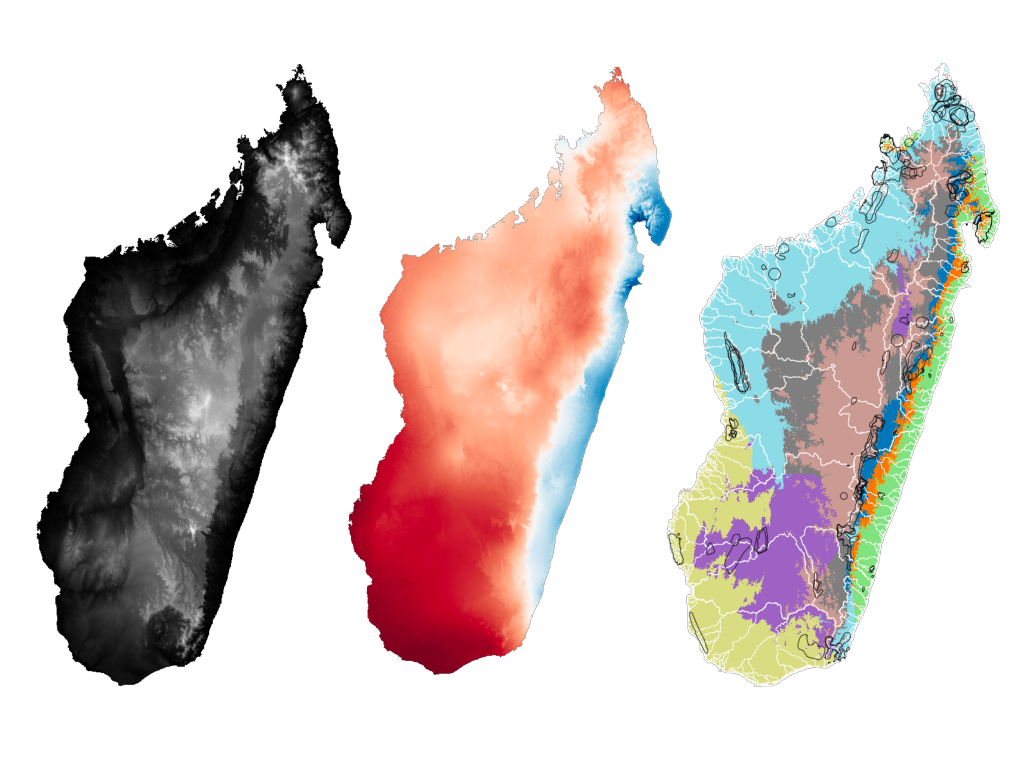
Long-term topographic history of Madagascar

Since its separation from Africa at ~150 Ma and from India at ~90 Ma, Madagascar has its own geological, geomorphic and biogeographic histories, providing an exceptional opportunity for investigating the relationship between the region’s landscape evolution and its biogeography. This project will recover the long-term topographic history of Madagascar for the past 150 million years, based on inversion of the sedimentary records, thermochronological data and the present-day topography. The modelled landscape will reproduce evolution of the island’s stream networks and drainage basin geometry, which will be used to test existing hypotheses of the Malagasy biogeographic evolution.
Project main investigators: Ruohong Jiao and Jean Braun.
Substrate controls on topography and erosion in bedrock landscapes

In bedrock landscapes, the interactions between substrate, process and form can give rise to a wide range of complex morphological behaviors. These interactions are often highly non-linear, making it a challenge to unpack the substrate dependence of topography and erosion in such landscapes.This problem can be tackled in numerous ways. One approach involves quantifying the lengthscale(s) at which substrate properties and topography are correlated. This information can then be used to learn more about the nature of the physical processes acting on bedrock landscapes, and to improve the ways in which we parameterize them. We have developed a new application of wavelet analysis that allows such correlations to be determined for 2D curvilinear landscape features. We are currently using this method to explore the substrate dependence of physical processes acting on rock coasts at a broad range of scales, from meters to kilometers, with particular focus on the role of discontinuities. However, this method is generalizable to any planar curve constructed from pairs of coordinates.
Project Investigator: Sam Wilson-Fletcher
Collaborators: Niels Hovius, Jean Braun, Benoit Bovy (GFZ), Eric Deal (MIT)
Marine transport and sedimentation in landscape evolution models

Limited attention has been given to linking continental erosion to marine transport and sedimentation in large-scale landscape evolution models. Although either of the two environments has been thoroughly investigated, the details of how climate and tectonic events are recorded in the sedimentary and stratigraphic records have not been studied in a consistent quantitative manner. Xiaoping Yuan´s project at GFZ, funded by the TOTAL COLORS project, is to develop a new numerical model for marine sediment transport and deposition that is directly coupled to FastScape, a landscape evolution model that solves the continental stream power law and hillslope diffusion equation using fully implicit and O(n) algorithms. The model of marine transport and sedimentation is simulated by a nonlinear 2D diffusion model where a source term represents mass flux arising from continental river erosion.
Project investigators : Xiaoping Yuan (GFZ, Potsdam), Jean Braun (GFZ, Potsdam), Laure Guerit (GET, Toulouse, France), Brendan Simon (Geosciences Rennes, France)
Inverting south African topography, thermochronological and sedimentary data to infer the uplift history of the craton over the past 100 Myr

The origin of the anomalous topography of the southern part of the African continent remains highly debated. Some postulate that it is long-wavelength dynamic topography, the expression of upward flow in the underlying mantle; others associate it with the onset of doming and extension in the East African Rift. We are using the FastScape landscape evolution model to invert sedimentary data from the offshore basins surrounding the south African craton, along with low-temperature thermochronological data compiled by Jessica Stanley, to derive estimates of the magnitude, distribution and timing of the uplift of the craton. The idea is to use an optimization method (the Neighbourhood Algorithm) to perform a large number of forward landscape evolution model experiments varying the model parameters to find the optimum values that represent the data. In doing so, we hope to provide quantitative and uncertainty-bound estimates of the uplift history of the continent.
Main findings so far:
- Models which match the erosion history data well suggest uplift of the eastern margin in the Cretaceous (~100 Ma) followed by uplift of the western margin ~20 Myr later. These results suggest that the scenario proposed by Braun et al. (2014) of uplift caused by the continent moving over the African superswell is viable.
-The amplitude of this uplift is on the order of 1000 m, and best fitting results suggest that there was significant topography (~800-1000 m average elevation) on the continent before it was uplifted in the Cretaceous.
- The comparison between the eroded volumes of sediment in the marine basins and the amount of erosion that needed to reset the thermochronology data suggests a significant amount of chemical denudation during the Cretaceous erosion event.
-The data cannot resolve whether there was smaller amplitude phase of uplift in the Cenozoic.
We are currently investigating the compatibility of other proposed uplift geometries to see whether they are also able to match the observed data.
Project main investigators: Jessica Stanley, Jean Braun.
Collaborators: François Guillocheau, Cécile Robin, Guillaume Baby, Université de Rennes 1, France; Becky Flowers, University of Colorado; Rod Brown, University of Glasgow.
Developing a new, fast algorithm for marine transport and sedimentation to invert the stratigraphic record
The transport of sediment in the marine environment has commonly been modelled using simple transport law that leads to a representation of the process by a diffusion equation. Many processes remain, however, poorly understood (e.g. transport and deposition in deep sea fans) and are unlikely to be properly represented by a simple diffusion equation. Furthermore, most existing models are relatively inefficient, which makes them unsuitable for use in inverting the stratigraphic record. We are currenly developing a new numerical method to develope O(n) efficiency and an implicit integration in time such that computational time is drastically reduced and is more appropriate for optimization. This work is being carried out within the framework of the COLORS project funded by Total.
Project main investigators: Xiaoping Yuan, Jean Braun.
Collaborators: Delphine Rouby, Université Paul Sabatier, Toulouse; Ritske Huismans, University of Bergen.
The weathering of continental interiors and the formation of pediments

In 2016, in collaboration with researchers from the Université Rennes 1, we published a new, simple parameterization of the rate of vertical propagation of a weathering front. We assumed that the rate of weathering is controlled by the ability of water flowing through the regolith to remove the product of the dissolution from the weathering front and, therefore, by the velocity of water along the interface. This leads to a relatively simple behaviour where the mean rate of propagation of the front beneath a topographic feature (hill) and its geometry, i.e. whether it is thicker near the top of the base of the hill, are controlled by two dimensionless numbers that only depend on a few model parameters such as the dimension of the hill, the mean erosion rate at the surface, the mean precipitation rate, the hydraulic conductivity of the regolith and a factor relating the rate of front propagation to fluid velocity. We are now in the process of implementing this simple parameterization in the FastScape landscape evolution model and using it to study the formation of pediments. Pediments are the flat, low slope, erosional surfaces that characterise many continental interiors. Through our modeling, we hope to demonstrate that pediments are exhumed weathering fronts, the shape of which is mainly controlled by the process responsible for the formation and propagation of the weathering front and not by the process responsible for its exhumation.
Project main investigators: Jessica Stanley, Jean Braun
Collaborators: François Guillocheau and Cécile Robin, Université de Rennes 1