

The EnMAP satellite has been in operation for a year now. The 1st EnMAP user workshop was another remarkable milestone for the Environmental Mapping and Analysis Program (EnMAP). Organized by the DLR Space Agency and the GFZ, this two-day virtual event, held on October 10-11, 2023, brought together over 430 registered users, from master students to senior researchers, on average, about 200 participants followed the workshop. They came from 20 countries, from research institutes, companies, and public authorities, showcasing the international interest of the user community for the mission and its data and for the excellent work that EnMAP is doing at all levels.
Background: The hyperspectral EnMAP mission
The EnMAP environmental satellite uses a hyperspectral sensor to measure the Earth in more than 250 colours (“spectral bands”) – even outside the visible spectrum. In this way, it provides information on the condition of vegetation, soil and water more precisely than ever before. The mission is under the scientific lead of the German Research Centre for Geosciences (GFZ) and is managed by the German Space Agency at the German Aerospace Center (DLR).
The workshop
Based on 46 presentations, the workshop's core focus was on providing participants with insights into the mission's progress, showcasing its potential, and fostering collaboration and exchange of information among its growing user community.
High data quality and user interest
Presentations and discussions on sensor characterization, data quality, calibration, and validation activities demonstrated and confirmed the continuous high data quality of the EnMAP sensor maintained over the 1st year of operation. It was confirmed that the mission continuously exceeds quality requirements regarding radiometric, spectral, geometric, and reflective characteristics and stability. An achieved signal-to-noise ratio (SNR) of better than 460:1 at a wavelength of 500 nm and better than 260:1 at 2200 nm provides a solid analysis basis for many applications.
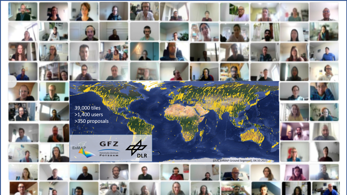
Since EnMAP is a user-driven mission, users can not only access the archived data but also place a proposal based on which they can request certain observations via https://planning.enmap.org/.
Due to its high data quality, EnMAP has received the interest from all over the world, and the intake capacity in this first year is overloaded with over 350 submitted data proposals and more than 1,400 users with EO data requests. The considerable interest in the EnMAP data led to high competition for observations over certain regions, where a long queue for EO data requests was observed, especially over Europe.
Broad spectrum of environmentally relevant utilisation topics
The data proposals already submitted by the users focused, e.g., on key research studies on ecological mapping, biodiversity, crop and soil health monitoring, mineral exploration, environmental mapping, water quality studies, snow and ice applications, plastic detection, and methane emissions mapping.
Early results for this wide range of environmentally essential applications were presented at the workshop. Besides the application references and general mission information regarding capacity utilization and product data quality, cooperating agencies (ESA, NASA, ASI) highlighted the importance of the EnMAP mission in the global and future context by presenting their current and upcoming Visible-Near Infrared / Short Wave Infrared (VNIR/SWIR) imaging spectroscopy missions.
Environmental challenges and applications ranging from soil and mineral mapping, agriculture and forestry, wetlands, inland and coastal waters, snow, and atmosphere were addressed during the workshop and showed the users’ excellent reception of the EnMAP Mission.
Summary by the scientific mission leader Sabine Chabrillat:
“As EnMAP enters its second year of operation, the workshop demonstrated the mission's achievements and potential to contribute to a better understanding of our environment. This was also demonstrated by the many key topics to which the scientific utilisation of EnMAP data is already contributing. The GFZ EnMAP Science team and the DLR Space Agency thank all participants and supporters for making the workshop a great success. Their commitment exemplifies the collaborative spirit that will continue to drive EnMAP's success,” summarises Sabine Chabrillat, scientific head of the mission, working group leader in GFZ Section 1.4 “Remote Sensing and Geoinformatics” and Professor of Digital Soil Mapping at Leibniz University Hannover.
Outlook: Next user workshop and the further development of software and training programmes
The next EnMAP User Workshop is scheduled for one to two years from now. It will again offer an opportunity to witness firsthand the mission's latest advancements and engage in face-to-face discussions with experts on the potential of multitemporal and multimission hyperspectral spaceborne datatakes for a wide range of application.
Meanwhile, GFZ goes ahead with its internal mission of providing scientific and technical mission support, continuing the high data quality monitoring program (EnVAL) and demonstration of new science capabilities from EnMAP, and developing its science program for further software tools included in EnMAP-Box and further education tools included in HYPERedu.
About the EnMAP mission
The EnMAP environmental mission is under the scientific management of the German Research Centre for Geosciences (GFZ) in Potsdam. The mission's scientific programme is being developed together with the international EnMAP Science Advisory Group. It is supported by the EnMAP Project PI (DLR Space Agency/BMWK) lead by GFZ with the German partners Alfred Wegener Institute in Bremerhaven, Ludwig-Maximilians University Munich, Humboldt-Universität zu Berlin and University of Greifswald.
The EnMAP mission is led by the German Space Agency at the German Aerospace Center (DLR) on behalf of the Federal Ministry of Economic Affairs and Climate Action (BMWK). The development and construction of the satellite and the hyperspectral instrument were in the hands of OHB-System AG. The total cost is around 300 million euros.
Further information about the EnMAP Satellite and the mission are available here:


![[Translate to English:] Hörsaal](/fileadmin/_processed_/e/6/csm_H%C3%B6rsal_f1d7c412b9.webp "[Translate to English:]")


