

EnMAP product validation (EnVAL)
One part of the science preparation and EnMAP mission support project led by the German Research Centre (GFZ) Potsdam, is the validation of the official EnMAP product regarding their quality. This validation has to be performed independently from the data quality control activities performed by the Ground Segment at DLR EOC. The validation tasks, sites and goals are defined in the Product Validation Plan (PVP) which has been prepared by GFZ and collaborators of the EnMAP Cal/Val Team. To comply with the PVP, the radiometric, spectral, geometric, reflective, and general quality of the three official EnMAP products (L1B, L1C and L2A) must be validated periodically and on-demand during the commissioning and nominal phase. The three official data products which have to be validated are:
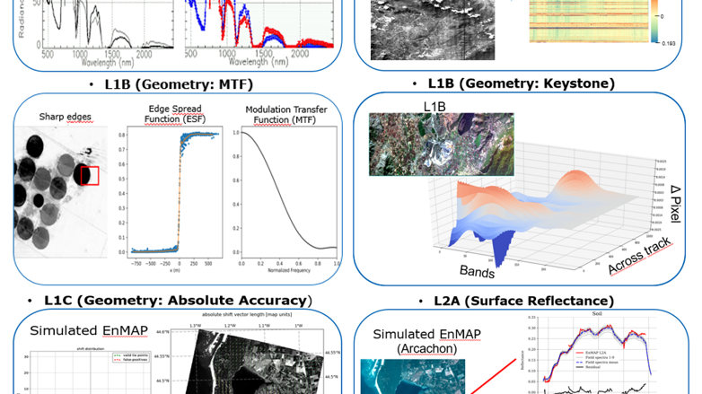
- L1B Product: radiometrically-corrected & spectrally-characterized radiance data
- L1C Product: geometrically-corrected L1B data
- L2A Product: atmospherically-corrected L1C data
Each of the three products is validated based on a set of parameters that define and represent the quality of the data. Some validation procedures are ground-based and therefore compare in-situ data provided by dedicated validation core sites, well-established validation/calibration networks and international collaborators. Other validation procedures are scene-based and thus can be performed on a set or a single EnMAP scene without the use of reference data.
The validation parameters are derived using a semi-automatic processing workflow that provides validation reports based on quantitative error figures. These figures support the identification of potential sources of errors and allow a trace-back to instrument and processing chain levels. The quantitative and qualitative results of the validation are compared with the official mission requirements and non-compliances have to be reported to the Ground Segment at DLR EOC.
publication & presentation:
Brell, M., Guanter, L., Segl, K., Scheffler, D., Bohn, N., Bracher, A., Soppa, M.A., Foerster, S., Storch, T., Bachmann, M., Chabrillat, S., 2021. The EnMAP Satellite –Data Product Validation Activities, in: 2021 11th Workshop on Hyperspectral Imaging and Signal Processing: Evolution in Remote Sensing (WHISPERS). Presented at the 2021 11th Workshop on Hyperspectral Imaging and Signal Processing: Evolution in Remote Sensing (WHISPERS), pp. 1–5. doi.org/10.1109/WHISPERS52202.2021.9484000
Chabrillat, S., Brell, M., Segl, K., Foerster, S., Guanter, L., Schickling, A., Storch, T., Honold, H.-P., Fischer, S., 2021. The EnMAP Satellite - Mission Status and Science Preparatory Activities, in: 2021 IEEE International Geoscience and Remote Sensing Symposium IGARSS. Presented at the 2021 IEEE International Geoscience and Remote Sensing Symposium IGARSS, pp. 123–125. https://doi.org/10.1109/IGARSS47720.2021.9553627
