


After a successful commissioning phase, the hyperspectral mission is now providing excellent data for applications in science and beyond.
Following its launch on April 1, the German environmental satellite EnMAP has successfully passed all tests and is now entering regular operation. All equipment and functional units on the satellite and in the ground stations have been brought into their nominal, i.e. productive, mode. Further, this also included the calibration and validation of the measured data, and the independent science product validation at more than 20 test measurement sites worldwide. Imagery was acquired for the different application areas of the hyperspectral satellite: from the monitoring of arid regions, soils, agricultural areas and environmental pollution to water and snow areas. Here, the satellite data were compared with reference values measured on the ground. After successful evaluation at the end of October, the EnMAP data will be made available to the user community via a data portal as of today, 2 November. Proposals for data acquisition can be submitted following the EnMAP Announcement of Opportunity. Detailed information about the mission is available on the mission website. Users can already learn how to use the new data in the HYPERedu online training programme. The EnMAP-Box provides software tools for analysing the data.
Background to the EnMAP mission: scientific lead by the GFZ
EnMAP stands for “Environmental Mapping and Analysis Program”. Over the next few years, the hyperspectral mission will acquire images of the Earth's surface in around 250 colours (“spectral bands”) and thus provide information on the condition of vegetation, soils and waters more precisely than ever before. Even short-term changes can be recorded with the help of the satellite, which is about the size of a wardrobe.
The mission is under the scientific management of the German Research Centre for Geosciences (GFZ) in Potsdam. The mission's scientific programme is being developed together with the international EnMAP Science Advisory Group. It is supported by the EnMAP Project PI (DLR Space Agency/BMWK) lead by GFZ with the German partners Alfred Wegener Institute in Bremerhaven, Ludwig-Maximilians University Munich, Humboldt-Universität zu Berlin and University of Greifswald.
The EnMAP environmental mission is led by the German Space Agency at the German Aerospace Center (DLR) on behalf of the Federal Ministry of Economic Affairs and Climate Action (BMWK). The development and construction of the satellite and the hyperspectral instrument were in the hands of OHB-System AG. The total cost is around 300 million euros.
Sabine Chabrillat, Scientific Principal Investigator of the Mission: “Excellent data quality”
“Our experiences with EnMAP data in the past two months are extremely promising and showed the excellent quality of the data. We are looking forward to the scientific exploitation of EnMAP data in several key geo and bio fields”, says Sabine Chabrillat, Scientific Principal Investigator of the Mission, Group Leader in GFZ-section 1.4 Remote Sensing and Geoinformatics and Professor for Digital Soil Mapping at Leibniz Universität Hannover. “EnMAP data with its higher capability for surface material identification and quantification can be used to support global and rapid land monitoring and tracking of several critical Earth System processes. For example, we can look at soil composition and organic carbon content, crops health, water quality, sustainable raw materials extraction, environmental pollution, super-emitters emissions, and many more.”
Susanne Buiter, Scientific Director of the GFZ: “Milestone in Earth imaging and open data policy”
“The EnMAP mission can be seen as a pioneering system for future global mapping missions that are currently in preparation by ESA and NASA. It represents a milestone in imaging spectroscopy”, says Susanne Buiter, Scientific Director of the GFZ. The unprecedentedly high data quality is ensured by onboard calibrations, which allows an accuracy in the quantification of surface properties unprecedented from space. Susanne Buiter emphasizes another point: “EnMAP is unique compared to other missions in the intensive scientific preparation and its open data policy, with the development of processing and analysis algorithms available online as free and open source, airborne flight campaigns, graduate student programs and an online teaching and training program, all aimed at enabling the user community to make the best possible use of the data.”
GFZ activities in the commissioning phase
Validation
GFZ is responsible for evaluating the overall quality of the official EnMAP products. During the seven-month commissioning phase, verification of sensor performance and calibration, and adjustment of Mission planning system took place. Intensive ground- and image-based validation activities started on 1 July. With the support of the EnMAP science advisory group and the support of international on-ground validation teams, we performed on-ground field spectroradiometer measurements simultaneous to EnMAP overpasses and compared them with the satellite signal. More than 20 validation sites globally cover different surface types (soil, vegetation, snow, and water), brightness levels, elevation, and atmosphere conditions.
First demonstration of applications with EnMAP data
The following two examples demonstrate how the international user community will benefit from working with the high-quality EnMAP data:
Example 1: Mineral mapping at Makhtesh Ramon
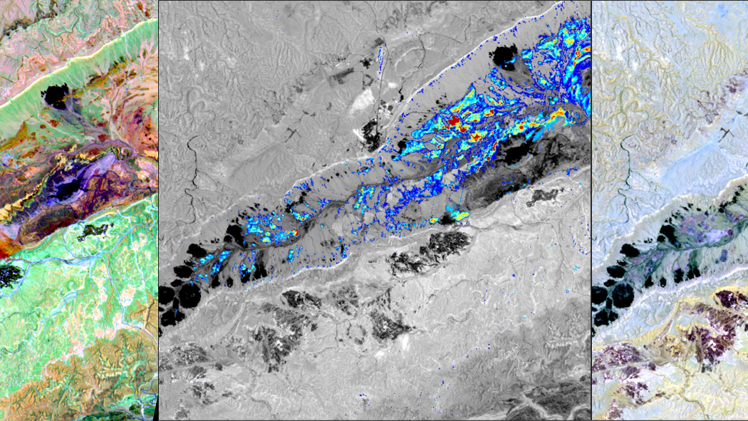
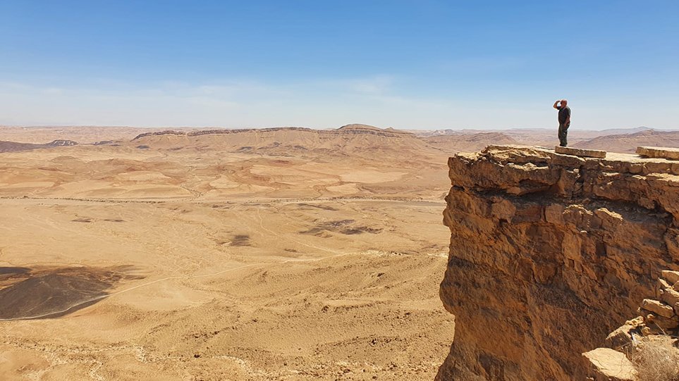
Makhtesh Ramon (Israel) is one of the largest eroded craters in the world and one of the test sites of the EnMAP validation campaign. The huge basin is located in the Negev desert, exposing fossils, volcanic cones, dykes, petrified coral reefs and a tremendous variety of minerals and rock outcrops. Today, Makhtesh Ramon is a national park that contains a variety of geological units including sandstone, iron oxide-rich rocks, gypsum, limestone, dolomite, clay minerals and plutonic crystalline rock units that, for the human eye, appears in fantastic red and yellow colours (see Fig. 1).
On July 8, 2022, EnMAP's hyperspectral sensor took an image over the Makhtesh Ramon Basin, complemented by field measurements from scientists at Tel-Aviv University's Remote Sensing Laboratory. EnMAP's eyesight goes far beyond what the human eye can see, and enables it to distinguish between different minerals such as kaolinite, montmorillonite, gypsum, calcite and iron oxides. The two exemplary visualizations give a first insight into the rich information content that can be retrieved with EnMAP.
EnMAP data are processed by the German Aerospace Center (DLR) so that geometric distortions and atmospheric effects are removed (Fig. 2). This processing level will thus be one of the main products distributed amongst users and will be the basis for advanced information products by providing high-quality data throughout the mission lifetime. An example of the excellent data quality is given by the map of kaolinite abundances (Fig. 3) as an important component of geological mappings, which was processed by the German Research Centre for Geosciences (GFZ).
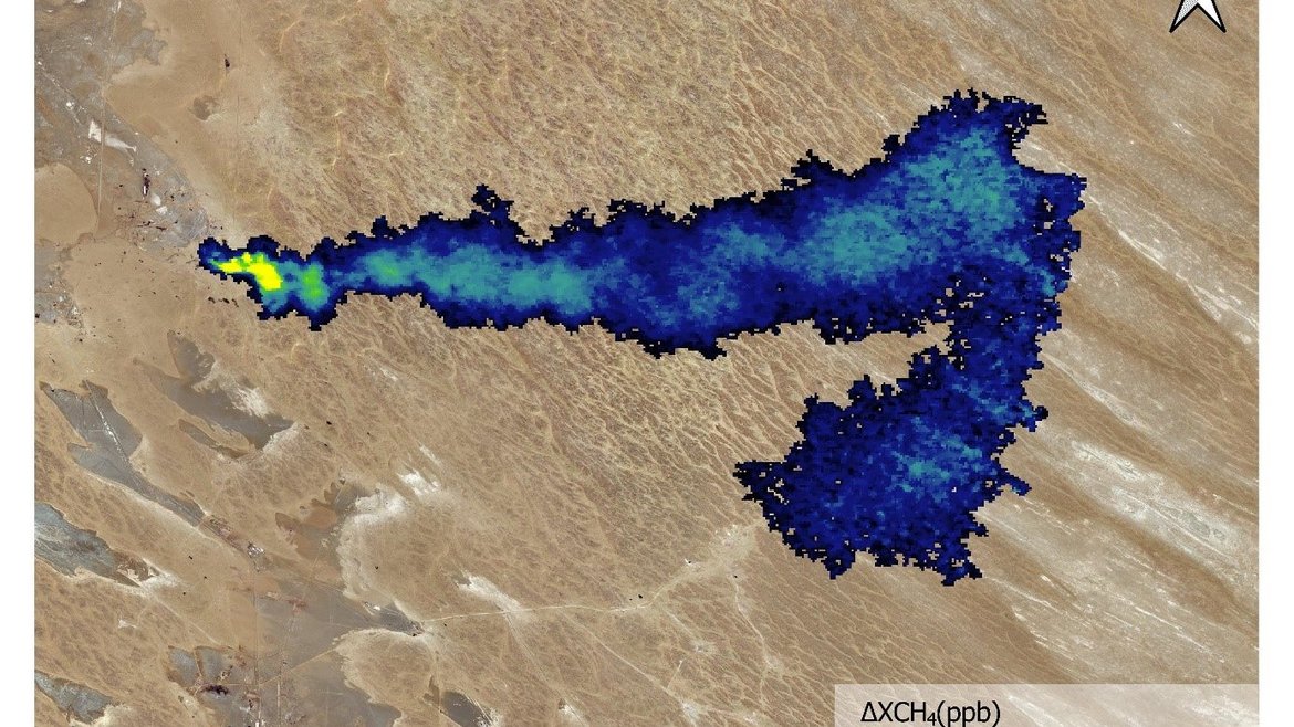
Example 2: Detection of methane sources in Turmenistan
(Text by Luis Guanter (Universitat Politècnica de València))
Fossil fuel production activities like oil and gas extraction and coal mining are responsible for a large fraction of anthropogenic methane emissions. These often happen as methane plumes containing relatively large volumes of gas emitted from so called “point sources”. The detection of such methane point sources around the world is critical for climate change mitigation efforts.
Based on first EnMAP data, researchers at the Universitat Politècnica de València have already confirmed the enormous potential of that hyperspectral satellite mission for this task.
Two data stripes of 30 x 90 km2 were acquired on 2 and 6 October over an oil and gas extraction basin in the southern part of Turkmenistan. At least seven so-called methane “super-emitters” have been found in the sampled area. An emission rate of about 17,000 kg/h has been estimated for the strongest plume as shown in Fig. 4. This large plume spans more than 10 km in length, and is affected by varying wind directions throughout this distance as evidenced by the turn in the plume orientation at its eastern end. This emission has been found to be caused by a malfunctioning flare which are used to burn excess natural gas, resulting into the less climate-impactful carbon dioxide.
Training program HYPERedu and software toolbox EnMAP-Box help with the scientific exploitation of the data
With EnMAP and other future hyperspectral satellite missions, an increasing interest in the analysis of hyperspectral data is expected in the coming years. To prepare users from all fields of applications, the online training program HYPERedu and a software toolbox EnMAP-Box were developed under the coordination of the GFZ in cooperation with a number of partner institutions in Germany and abroad. They offer a wide range of teaching materials on the fundamentals, methods and applications of hyperspectral remote sensing and software for the data analysis and retrieval of thematic products related to geological applications, soil mapping applications, forest and agriculture.
So far, more than 1500 people have enrolled to the course, 300 have already successfully completed it. In December, a new second course focusing on agricultural applications will be opened.
Outlook to the routine phase
Three DLR institutes and facilities have been commissioned with the operation of the ground segment: The German Space Operations Centre in Oberpfaffenhofen is responsible for carrying out and monitoring satellite operations. The German Remote Sensing Data Center and the DLR Remote Sensing Technology Institute archive the received satellite data, process and validate them and make them available to the scientific community. Companies and public authorities will also use the data and thus preparing future services. The use of EnMAP hyperspectral data by universities and scientific institutions and the development of special applications are supported by BMWK funding programmes.
During the operational phase of the mission, the GFZ will be responsible for the scientific mission support along with the EnMAP Science Advisory Group, such as for the support of the DLR Agency and the ground segment with fulfilling the mission goals, definition of EnMAP announcement of opportunities and evaluation of data proposals, the definition of core observation areas and of the background mission. Additionally, the GFZ will be further responsible for the external validation of the product quality, the development of analysis algorithms, the demonstration of the data potential in core application fields such as mineral mapping and agriculture, but also the exploration of new application fields, and the information, training and networking of the user community.
Further information about the EnMAP Satellite and the mission are available here:


![[Translate to English:] Hörsaal](/fileadmin/_processed_/e/6/csm_H%C3%B6rsal_f1d7c412b9.webp "[Translate to English:]")


