


Update: 9. February 2023
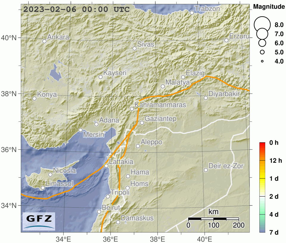
On February 6th at 01:17:34 UTC (4:17 am local time) a strong earthquake of magnitude 7.7 occurred in southeastern Türiye. About nine hours later, at 10:24;49 UTC, a second large earthquake with magnitude 7.6 occurred. Those events were followed by a large number of aftershocks. The earthquakes took place in the Gaziantep region with a population of more than 2 million.
Türkiye is crossed by two large active seismic zones. The tremors of 6 February occurred along the East Anatolian Fault Zone (EAFZ). Here, the Anatolian and Arabian plates meet and move sideways (left-lateral) past each other at about 1,4 cm/year (Bulut et al, 2012). This friction causes earthquakes, some of them strong, to occur at irregular intervals. During the last 100 years the seismic activity along the EAFZ has been unusually quiescent (in contrast to the North Anatolian Fault Zone - NAFZ). Thus, the entire zone has built up stress over this long period and it was only a matter of time before earthquakes, such as hit now, actually happened. The SW part of the EAFZ was activated over a length of 180 kilometres and from the surface to a depth of about 20 kilometres (over the entire seismogenic / brittle crust). It is indeed likely that the remaining areas of the EAFZ continue to be critically stressed through accumulated energy or have even been advanced in their seismic activity by the quakes of February 6.
The area hit by the earthquakes from February 6 forms a so-called triple junction of three tectonic plate boundaries between the East Anatolian Fault Zone, the Dead Sea Transform Fault (DST), also a continental plate margin fault that stretches to the Gulf of Aqaba, and the Cyprus Arc, which is a subduction zone similar to the Hellenic Arc.
It is unlikely that this earthquake will affect the seismic hazard in the in the Istanbul region due to the large distance. Nevertheless, the seismic hazard along the North Anatolian Fault Zone and thus for Istanbul remains high, as it was before the earthquakes in eastern Türkiye.
Facts:
- Not preceeded by any foreshock with M > 4
- Closest station from GEOFON in Cyprus: 400 km.
- Early warning system: only implemented for the Marmara region, at the moment only oriented to shut down power and gas.
- Epicentre: 37.23° N 37.05° E, Depth 10km
Largest known earthquakes along the East Anatolian Fault Zone
The largest known earthquakes along the EAFZ occurred on November 29, 1114 (M > 7.8), March 28, 1513 (M > 7.4) and March 2, 1893 (M > 7.1) [Ambraseys and Jackson, 1998], respectively. These large devastating historical earthquakes contrast with only one large earthquake during the last century (on December 4, 1905; M = 6.8) [Nalbant et al., 2002]. Çetin et al. [2003] interpreted the apparent seismic quiescence along the entire EAFZ to indicate that the fault is currently locked.
Earthquake Information:
- EARTHQUAKE EXPLORER
The Earthquake Explorer application was developed at GFZ to provide rapid information on recent earthquakes worldwide as well as earlier earthquakes back to August 2007.


![[Translate to English:] Gruppenbild mit 4 Personen](/fileadmin/_processed_/8/d/csm_20241017_GFZ-Emmerman-Medal-005_web_reinhardtundsommer_db407e5dc8.webp)


