


The outermost solid shell of the Earth, the Earth’s crust, is regarded by human beings as their foundation. To understand and survey this anthroposphere, as well as to make predictions about its evolution and use is the task of near-surface and applied geophysics. In doing so, it is equally important to understand the global processes of plate tectonics and what drives geodynamics, as well as it is to study small-scale phenomena that, for instance, may influence the decision how to utilize the subsurface (e.g., exploration, water, infrastructure). Equally, imaging, quantification, and assessment of geohazards at an early stage (e.g., mass movements, sinkholes, environmental changes) are challenging, the more if they occur in urban areas.
In order to explore the subsurface we apply various geophysical methods which are sensitive for different physical properties. In four working groups we concentrate on seismic and electromagnetic methods. In field experiments and on the computer - and supported by innovative developments of measuring instruments - these methods are further developed. With the help of simulations these methods are used for predictions of the subsurface structure of the subsurface and the involved processes.
Our aims and tasks
- Carry out basic and applied research as entity.
- Foster prediction capabilities with non-invasive measurements. Enhance exploration and monitoring for and during subsurface use.
- Aid assessment of natural hazards and georesources.
- Develop quantitative methods especially for urban areas and related to hazards.
- Provision of large infrastructure for the geo-community
Applied Seismics
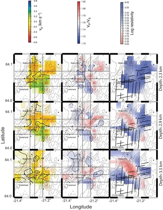
Active and passive seismic methods are used in our group to study unconventional reservoirs (gas hydrates, gas shales, geothermal). The exploration of such resources requires knowledge of the seismic properties. We carried out crosshole tomography in gas hydrates and found unusual seismic characteristics. Gas shales are studied using core analysis, near-surface tomography, and seismic reflection processing. Geothermal exploration projects were carried out in the Central European basin and in Island. A new project started now to develop geothermal energy in Indonesia.
Geophysical Instrument Pool Potsdam (GIPP)

The "Geophysical Instrument Pool Potsdam (GIPP)" provides seismic and magnetotelluric instruments and sensors for joint projects with universities and other research facilities. It is hosted by our section. We develop hardware and take care of data archiving. more information
Geo- Electromagnetics
Development and application of electromagnetic methods for exploration and monitoring of the underground, e.g. for georesources, geodynamic processes and natural hazards. Operation and development of Controlled Source EM, e.g. with respect to numerical approaches (3-D and time-lapse inversion).
Magnetotellurics

Development of passive electromagnetic methods, e.g. for fossil and recent fault zones, georesources or fluid systems. Rock physical characterisation of the underground, e.g. with 2-D/3-D and anisotropic inversion aproaches. Expansion of MT to near-surface RMT, e.g. for near-surface leakage systems.
Sub-/seismic Deformation Modelling
Further development of qualitative and quantitative prediction tools for fault and deformation modelling, e.g. for fractures and pathways in subsurface or areas of potential concern in hazard maps.


