

Summary
Between November 2022 and March 2023, an unusual series of earthquakes struck the region around Peace River in the north of the Canadian province of Alberta. As there is also industrial activity in the geological subsurface in the region, the question arose as to whether the quakes were induced or of natural origin. A study by researchers led by Hannes Vasyura-Bathke and Torsten Dahm from the German Research Centre for Geosciences in Potsdam, together with colleagues from Canada, confirms the suspicion that the quakes were triggered by industrial wastewater disposal that had started 10 years earlier. The findings are based on a detailed analysis of the quakes using seismic measurements and satellite-based radar (InSAR), which were analysed using modern statistical methods. The study has been published in the journal Nature Communications Earth & Environment.
Series of earthquakes near Peace River: natural or man-made?
In November 2022, a series of earthquakes hit a previously seismically relatively quiet location near the town of Peace River in northern Alberta, Canada. The main earthquake with a magnitude of MW 5.2 on 30 November was preceded by four foreshocks with magnitudes above 4.0. This was followed by a longer series of aftershocks, including two with magnitudes MW 4.5 and 4.6 on 16 March 2023.
There is extensive industrial activity in the region, including the extraction of heavy oil by steam injection and the massive disposal of wastewater at various depths in the rock. This has led to a discussion about whether the unusually strong earthquakes are of natural origin or caused by human activity.
Earthquakes triggered by human activity usually occur in weak zones in the rock. They are similar to natural earthquakes, but start at shallower depths. Although the area is seismically rather quiet, there have been both natural earthquakes and earthquakes triggered by industrial activity within 500 kilometres of Peace River in the past.
In 2023, the local authorities initially assumed that the earthquakes were natural, as there had been no hydraulic fracturing in the vicinity during the period in question, the injection rates for saltwater disposal had not changed in the previous year, and an initial estimate of the focal depth of six kilometres was below expectations for induced earthquakes at this location.
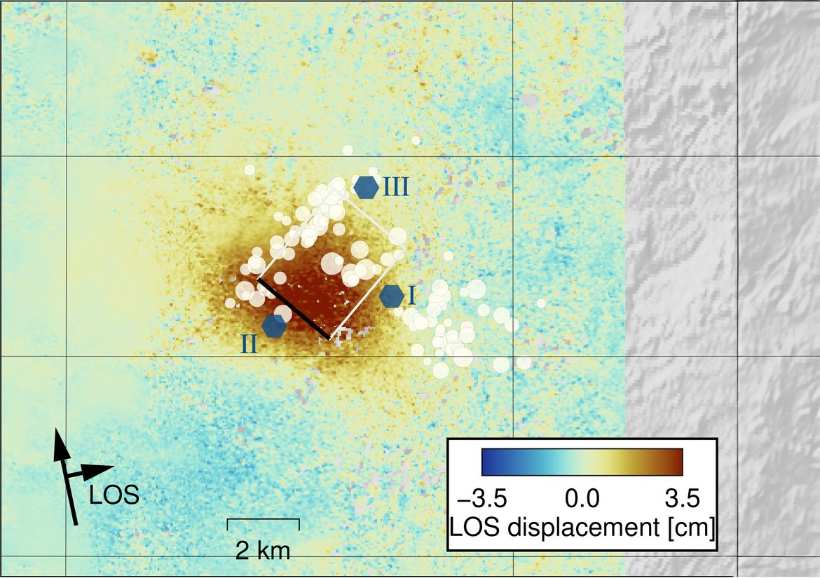
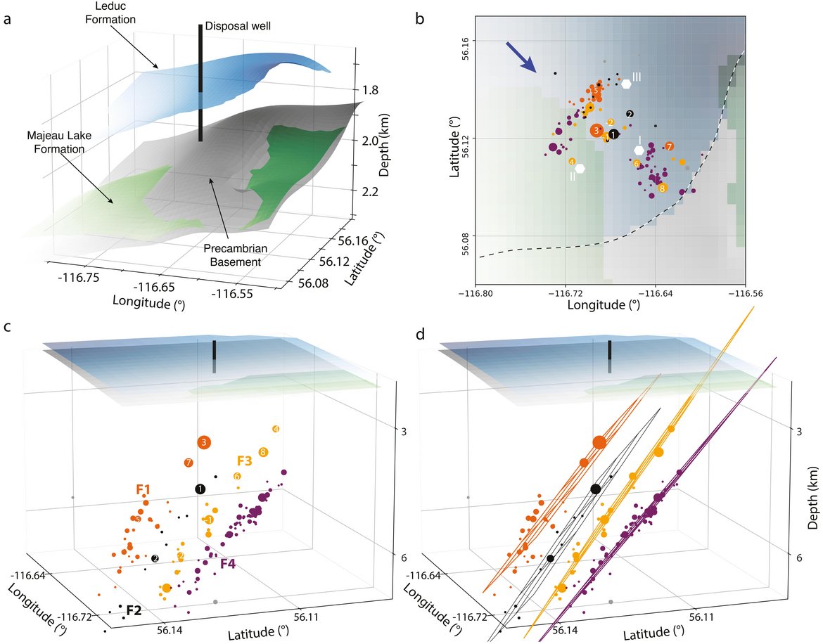
However, initial scientific investigations led to a different assessment: Schulz et al.1 interpreted the earthquakes primarily as a result of wastewater injection into a deep disposal well about 3.5 kilometres east of the epicentre of the mainshock. It extends into the aquifer system within the so-called Leduc formation.
Research project on the origin of the earthquakes
A team led by Hannes Vasyura-Bathke, scientist in the GFZ Section 2.1 ”Physics of Earthquakes and Volcanoes”, and Torsten Dahm, head of the same section and professor at the University of Potsdam, has now been able to contribute to the further clarification of the earthquake processes. Together with scientists from Canada – from the University of Calgary, the Canadian Hazards Information Service and the Canada Centre for Mapping and Earth Observation – they have investigated the earthquake series in Peace River in detail. Their study, which was published in the journal Nature Communications Earth and Environment, confirms the colleagues' assumption that the earthquakes were influenced by the wastewater injections.
“We wanted to analyse exactly how, where and when the quakes occurred in order to be able to draw conclusions about their origin,” says Hannes Vasyura-Bathke, explaining the aim of the study. The researchers therefore analysed the main earthquake and over 130 aftershocks that occurred between November 2022 and March 2023. They used various methods to understand the characteristics of the main shock, the existing weak zones and the possibility of future earthquakes.
In particular, they relied on both seismic data and a special type of remote sensing data called interferometric radar (InSAR), which can measure deformations of the Earth's surface. To analyse the data, they used a statistical method known as Bayesian inference. This is a concept that allows hypotheses generated by modelling to be tested using successively integrated data. “The combination of InSAR and seismology helps to significantly reduce the uncertainty of our analyses,” says Vasyura-Bathke.
The anatomy of the fault system
The researchers were able to reconstruct the source of 132 earthquakes and the exact location and rupture characteristics of eight major events. The distribution of the earthquakes shows an anatomy of the rupture system with four almost parallel zones of weakness extending to the north-west, whose reactivation is favoured in the current stress regime. However, these are intersected by a transverse fault zone that is difficult to reactivate. Some areas of the weak zones appear not to have ruptured, indicating a continuing seismic hazard.
The main shock originated at a depth of about five kilometres, propagated upwards along the weak zone towards the injection source and terminated at a depth of about two kilometres.
Earthquake caused by industrial salt water disposal
“Our results support the conclusion that the discharge of wastewater into the Leduc Formation probably played a key role in triggering this sequence,” summarises Hannes Vasyura-Bathke. “If the assessment is correct, the main earthquake of this series is the strongest triggered earthquake in western Canada to date.”
In general, proximity to crystalline bedrock is an important geological risk factor for earthquakes caused by human activity. The Leduc Formation, into which the wastewater was injected, lies directly above the Precambrian basement. This direct contact increases the likelihood that a hydrological connection exists between the Leduc Formation and the deep-seated weak zones. And such a connection supports the argument that the earthquakes were influenced by the ongoing injections.
A diagnosis with consequences: Even ten years after injection began, earthquakes can occur for the first time
“The extraordinary time span of eleven years between the start of wastewater injection and the activation of the fault is particularly remarkable. This reflects the long time it apparently took for the rock to reach a critical state,” says Hannes Vasyura-Bathke.
“Our observations show that weak zones in the rock can be activated by continued wastewater injection, even ten years after the start of disposal activities. It is therefore possible that further disposal will lead to more earthquakes,” says co-author Torsten Dahm. “The results from Canada show how long it can take to trigger earthquakes and how important it is to monitor regions with underground industrial activities over the long term.”
Original publication
Vasyura-Bathke, H., Dettmer, J., Biegel, K. et al. Bayesian inference elucidates fault-system anatomy and resurgent earthquakes induced by continuing saltwater disposal. Commun Earth Environ 4, 407 (2023). DOI: 10.1038/s43247-023-01064-1
https://doi.org/10.1038/s43247-023-01064-1
1Schultz, R. et al. Disposal from in situ bitumen recovery induced the ML 5.6 Peace River earthquake. Geophys. Res. Lett. 50, e2023GL102940 (2023).


![[Translate to English:] Hörsaal](/fileadmin/_processed_/e/6/csm_H%C3%B6rsal_f1d7c412b9.webp "[Translate to English:]")


