

08.05.2017: Embankment dams are built to form water reservoirs, to supply hydro power stations or for flood control. Depending on the volume of water stored the dams are exposed to enormous hydraulic pressure. Due to this, about ten severe damages occur globally within a decade. An international team of three scientists from Iran and Germany with the participation of Mahdi Motagh, GFZ section Remote Sensing, now demonstrated how the monitoring of embankment dams can be improved by satellite data, at the example of the Masjed-Soleyman dam in Iran.
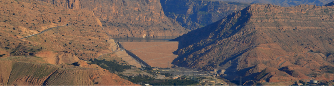
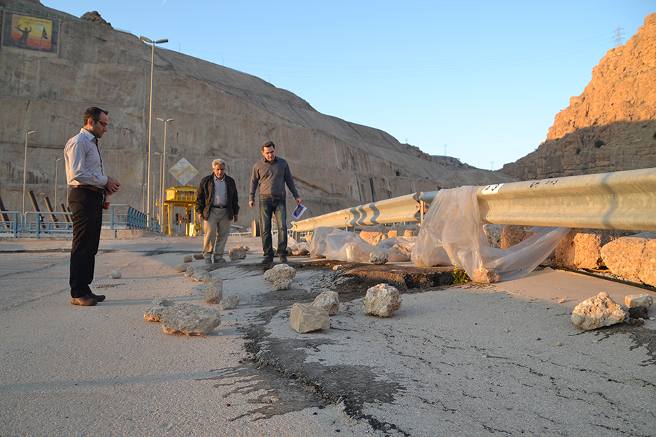
The Masjed-Soleyman embankment dam has a height of 177 metres and a width of about 500 meters and was built between 1995 and 2000 at the Karoun River in Southwest Iran. Like most embankment dams and unlike concrete dams it consists of earth and rockfill. The dam mainly serves as a hydroelectric power station. With the completion of the dam a ground-based monitoring system was installed. Its particular importance became clear after the first impoundment of the dam, when cracks started to develop on the street in the dam crest that are a sign of deformation movements within the dam.
This monitoring system includes 25 target points on the dam body. Their motion can be measured from stable reference points around the dam. The measurements are conducted regularly and thereby allow for a monitoring of the vertical and horizontal offset within the dam through time. The measurements, however, only provide information on these exact target points. Information on the interspace needs to be interpolated.
Satellite data complement the ground-based measurements
Continuous monitoring of the deformations of a dam is important to ensure the safety of the downstream area and an interference-free power supply for integrated water power stations. The rapid development of space technology and data processing over the last twenty years today allows for an application of microwave remote sensing techniques and Synthetic Aperture Radar Interferometry (InSAR) as a precise geodetic tool to monitor movements of the Earth’s surface. New possibilities offered by modern high-resolution radar remote sensing images extend the applicability of InSAR to more detailed mapping and monitoring of structural stability of infrastructure at risk.
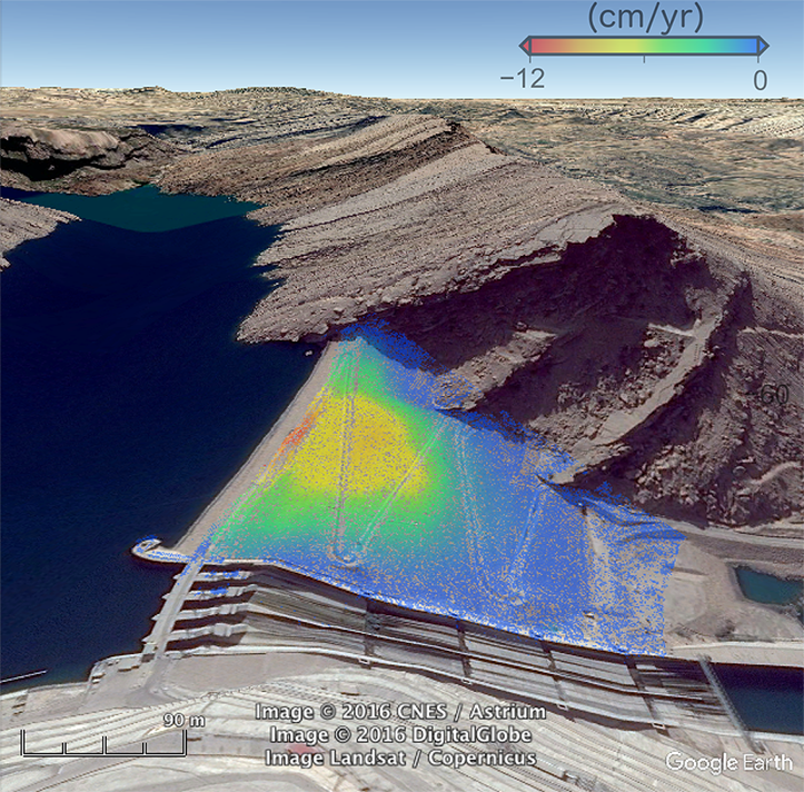
Within the feasibility study, published in Engineering Structures, the team analyses remote sensing data recorded by the German Earth observation satellite TerraSAR-X. Every eleven days the satellite crosses the Masjed-Soleyman dam and takes measurements of the Earth’s surface with a resolution of one metre. Based on these data the scientists were able to detect deformation pattern of the dam with high precision and in much more spatial detail than is currently possible with any other ground-based geodetic and geophysical instruments. The combined effect of the rock mass of the dam and the hydraulic pressure causes a subsidence of approximately thirteen centimetres on the crest and downstream movement of about seven centimetres per year. This strain stress leads to cracks threatening the long-term stability of the dam.
Developing models for an increased dam safety
The scientists show that the new class of high-resolution space-born systems, like TerraSAR-X, allows for a very detailed survey of an ongoing destabilization of the dam in the future. Mahdi Motagh: “We believe that our results can be generally applied to dams with the same construction. The high-resolution satellite systems that deliver a new class of radar images with a resolution of up to 25 centimetres, compared to typically 10 to 20 metres available so far, have revolutionized the ability to asses infrastructure stability from space.” The scientists assume that an integration of such data with ground-based measurements and other parameters like the volume of water stored, the construction of a dam or the geological features of the subsurface are particularly helpful in developing reliable models for stability analysis in the future. (ak)
Original study: Emadalli, L., Motagh, M., Haghshenas Haghighi, M., 2017. Characterizing post-construction settlement of the Masjed-Soleyman embankment dam, Southwest Iran, using TerraSAR-X SpotLight radar imagery. Engineering Structures 143, 261 – 273. DOI: 10.1016/j.engstruct.2017.04.009


![[Translate to English:] Hörsaal](/fileadmin/_processed_/e/6/csm_H%C3%B6rsal_f1d7c412b9.webp "[Translate to English:]")


