

Segmentation of Oceanic Spreading Ridges
Segmentation of spreading ridges is a common feature in nature. The length of ridge segments varies between a few kilometers to hundreds of kilometers. Previous observational studies have shown that segmentation is controlled by factors such as rate of spreading, tectonic inheritance, mantle flow, and plume impingement. In this project we use 3D numerical modeling software (I3ELVIS) to simulate ridge segmentation under oblique extensional tectonic settings in order to investigate the relative impact of these factors. We expect that our results elucidate observation in oceans worldwide (e.g., North Atlantic, East Pacific, South West Indian Ocean).
![[Translate to English:] Diese Karte zeigt den Golf von Aden.](/fileadmin/_processed_/4/4/csm_Jiarong_Project_2c05dd3a19.png)
Project duration: 01/2024 - 12/2024
Funding agency: China Scholarship Council
PhD candidate: Jiarong Qing
Supervisors: Sascha Brune, Jie Liao
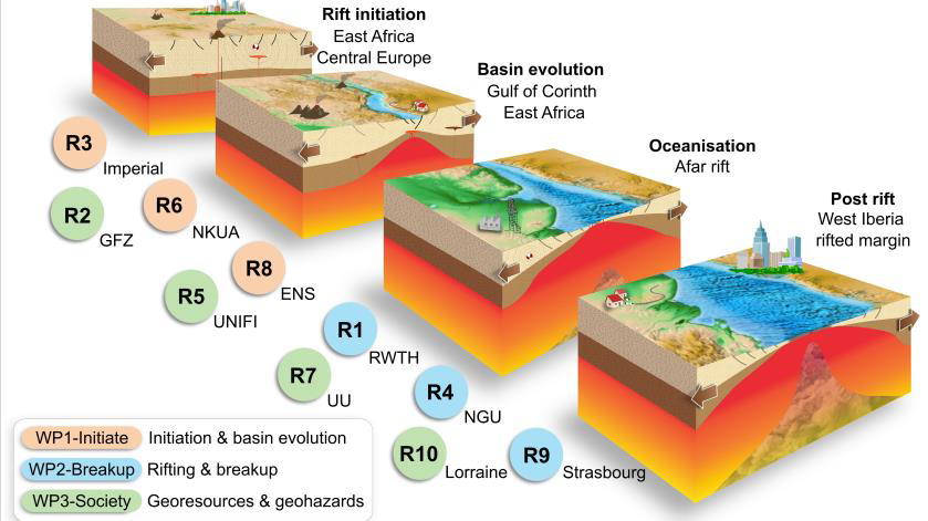
TALENTS - The doctoral rift science network for the energy transition
Climate-CO2 emission models point to the urgency for European society to transition from high to low carbon energy sources. This is why we investigate continental rifts, forefront areas for carbon capture, geothermal energy, and new resources such as native hydrogen. The objectives of the EU-funded Marie Skłodowska-Curie Doctoral Network TALENTS are to (1) increase our understanding of rift initiation, continental break-up and how rifts link to societal benefits and geohazards, (2) train 12 Doctoral Researchers in scientific, networking, communication and entrepreneurial skills related to the energy transition, and (3) build a collaborative network ensuring results and knowledge are shared with academia, industry, and society. The TALENTS network comprises 7 Beneficiaries, 10 academic partners, 11 industry partners, 11 media contacts and altogether more than 70 individuals with highly with complementary expertise. For more info see: https://www.talents-dn.eu/
Project duration: 2024-2027
Funding Agency:Marie Skłodowska-Curie Actions - Doctoral Network
Grant Agreement: 101119486
Project Coordinator: Sascha Brune
Collaborators: Gabriela da Poian, Susanne Buiter, Judith Bott, Anne Glerum, Mauro Cacace, Ameha Muluneh
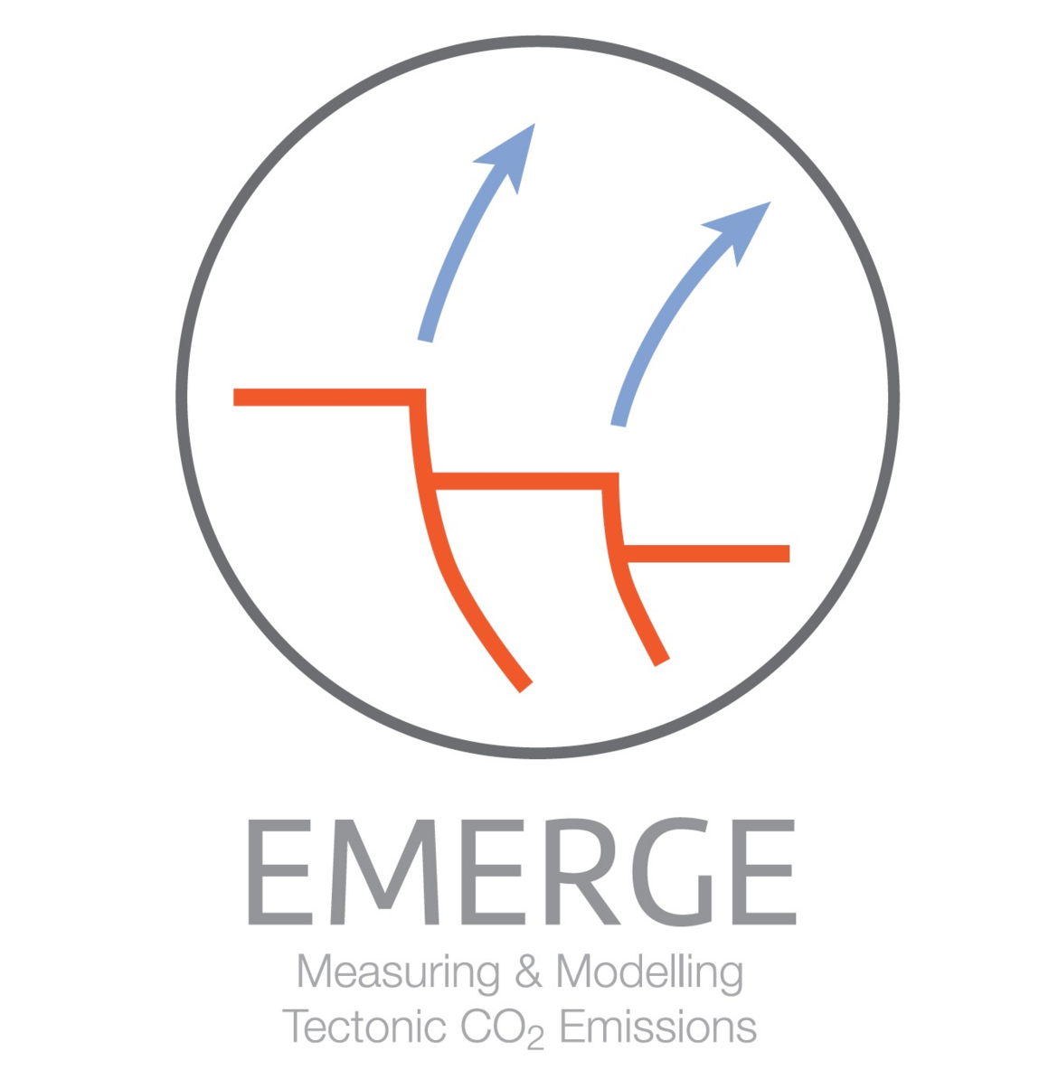
EMERGE - Measuring and Modelling Tectonic CO₂ Emissions Through Time
Geological processes have caused large CO₂ fluctuations in the past and influenced the climate. In recent studies, massive CO₂ emissions have been detected at continental rifts. The EMERGE project links three innovative approaches to measure and model such CO₂ outgassing. First, will use innovative techniques to measure CO₂ fluxes at European and East African rifts. In addition, novel modeling techniques are being developed to investigate the controls of geodynamic processes on CO₂ transports in the lithosphere. A third approach is to integrate data from the last 540 million years of all known rifts worldwide. This will allow to understand the role of tectonic degassing at continental rifts in shaping Earth’s climate through time.
Project duration: 2023-2028
Funding agency: ERC (European Research Council) Consolidator Grant
Grant Agreement: 101087245
Project Coordinator: Sascha Brune
Collaborators: Anna Jentsch , Mathias Zöllner , Anne Glerum
Geo-Inquire
Funded since October 2022 by the European Commission, Geo-INQUIRE provides to the scientific community virtual and transnational access (VA and TA) to about 150 installations hosted by 51 consortium partners – major national research institutes, universities, national geological surveys, and European Research Infrastructure Consortia including EPOS, EMSO, and ECCSEL and the ChEESE Centre of Excellence. The 4-year project aims to further enhance and harmonize data and service provision, strengthen the multi-disciplinarity and interoperability to overcome cross-domain barriers, especially in the land-sea-atmosphere environments. Integration of different data, including new observables, products, and services will be optimized and demonstrated through TA activities at 7 multi-disciplinary test beds, besides open training workshops and summer schools. Ultimately, Geo-INQUIRE strives to enable the next generation of geo-scientists to carry out leading-edge research addressing societal challenges from a multi-disciplinary perspective, and making intelligent use of the available geo-research infrastructures.
Section 2.5 is contributing to the coordination of the Geo-INQUIRE Work Package WP5: “Access to the next- generation software and workflow as a service” as well as to the development and provision of the new Virtual Access (VA) to the instant tsunami modelling tool “Gaussian Toolbox”. This service is a joint product with INGV (Italy) colleagues; it implements the concept of surface tsunami Green’s functions to instantly quantify coastal tsunami wave heights for arbitrary seismic sources in the Mediterranean region.
Project duration: 2022 - 2026
Funding agency: European Commission through the "Horizon Europe Programme"
Grant Agreement: 101058518
Project Coordinators: Fabrice Cotton (2.6) and Angelo Strollo (2.4)
PI in section 2.5: Andrey Babeyko
Involved GFZ-sections: 2.1, 2.4, 2.5, 2.6 (plus 2.2, 4.2, 5.1 )
The ascent of Eifel plume and its interaction with European lithosphere and asthenosphere
The Eifel hotspot, situated in western Germany, has been volcanically active for several tens of millions of years. Previous studies have indicated that the source of these long-term volcanic activities is a plume visible in the upper mantle and in some models of the lower mantle. However, the deep origin of the plume is still under debate, since the tomography images do not consistently show a continuous plume conduit between the surface and the core-mantle boundary and the Eifel hotspot is not related to any flood basalt province or a clearly age-progressive hotspot track. It has also been proposed that there is a stagnant slab in the mantle transition zone created by the Alpine-Mediterranean subduction zone. This stagnant slab might be interacting with the Eifel plume, but so far this mechanism has not been studied in detail using a geodynamic approach. In addition, the ascent of the Eifel plume and the other sub-lithospheric drivers of vertical motion (such as edge-driven convection or cooling and accretion of sub-lithospheric mantle) as well as lithosphere deformation might cause dynamic topography at the earth surface in central Europe. However, so far the relative contributions of these processes during the Cenozoic are still controversial.
In this project, I intend to employ the geodynamic research software ASPECT to model the lithospheric-scale surface response of Central Europe to plume impingement, small-scale convection and plate tectonic forcing, and try to decompose the present-day topography into individual components. Also, I will conduct 3D models with high resolution and complex rheologies to explain the possible origins of the Eifel hotspot and to address how the plume and the stagnant slab interact with each other
![[Translate to English:] Prototype model (Steinberger et al., 2019) for a study focusing on the role of the Iceland plume for the distribution of volcanics during North Atlantic and Labrador Sea rifting](/fileadmin/_processed_/c/9/csm_Project_Yingying_3973edc25c.png)
Project duration: 2022-2026
Funding agency: China Scholarship Council
Phd candidate: Yingying Li
Supervisors: Bernhard Steinberger, Sascha Brune, Eline Le Breton
Monitoring Earth Evolution through Time (MEET)
Alexander Sobolev (IsTerre, Grenoble), Stephan Sobolev (GFZ Potsdam, Germany) and John Valley (University of Wisconsin, Madison, USA) have been awarded an ERC (European Research Council) Synergy Grant of 12.8 million euros over six years (2020-2026) to study the evolution of Earth's chemical composition and underlying physical processes from 4.4 billion years ago to the present day in a project called Monitoring Earth Evolution through Time (MEET).
![[Translate to English:] The image presenting the idea of the ERC Synergy Grant Project MEET that combines chemical and physical methods to study evolution of Earth since the very early stage of its life.](/fileadmin/_processed_/4/1/csm_ERC_Grant_Sobolev_01b01c7153.jpg "[Translate to English:] The image presenting the idea of the ERC Synergy Grant Project MEET that combines chemical and physical methods to study evolution of Earth since the very early stage of its life")
Project duration: 2020-2026
Funding agency: ERC Synergy Grant
Primary Investigator: Stephan Sobolev
Postdocs: Charitra Jain, Michael Pons
Cooperations:Alexander Sobolev (ISTerre, Grenoble), John Valley (University of Wisconsin, Madison,USA), Jean Braun (GFZ), Georg Feulner (PIK), Sascha Brune (GFZ)
DT-Geo
A Digital Twin for GEOphysical extremes (DT-GEO) is a European project that aims to analyse and forecast the impact of tsunamis, earthquakes, volcanoes, and anthropogenic seismicity. Main objective of DT-GEO is to deploy a pre-operational prototype of Digital Twin, implemented through 12 self-contained Digital Twin Components (DTCs) addressing specific hazardous phenomena, for its future integration into the Destination Earth initiative. DTCs will combine real-time data streams and high-fidelity models to conduct precise data-informed early warning systems, forecasts, and hazard assessments across multiple time scales. Also foreseen is integration of project assets and outcomes into the European Plate Observing System (EPOS) and HPC/virtual cloud computing (EuroHPC) Research Infrastructures.
Section 2.5 is involved into the development of the Digital Twin Component DTC-T1 implementing the workflow of the novel tsunami forecasting methodology coined Probabilistic Tsunami Forecasting (PTF). The workflow is planned for employment in the Tsunami Early Warning Centres. It provides probabilities of exceedance of given tsunami intensities at given coastal locations. PTF performs data assimilation of (near-) real time earthquake and tsunami observations into the tsunami simulation workflow operating ensembles of precomputed or on-the-fly simulated tsunami propagation scenarios.
![[Translate to English:] This illustration represents the DT-Geo project.](/fileadmin/_processed_/5/2/csm_DT-Geo_1411cc9e1c.png)
Project duration: 2022 - 2025
Funding agency: Horizon Europe under the grant agreement No 101058129.
Primary Investigator: Sascha Brune
Modelling mantle exhumation during rifting and basin inversion: Implications for natural hydrogen exploration
In the on-going push for developing new, eco-friendly resources and energy production, the potential of naturally occurring hydrogen, generated through the alteration (serpentinization) of tectonically exhumed mantle rocks, remains largely overlooked. The exhumation of mantle rocks can occur during rifting and continental break-up, but as well as during mountain building phases. In order to better assess the opportunities for natural hydrogen extraction from exhumed mantle material, we must improve our understanding of the tectonic processes leading to (and active during) their exhumation.
This project envisions the use of numerical tectonic modelling techniques to unravel these mantle exhumation processes, with a special focus on the influence of structural inheritance, pressure and temperature evolution of exhumed mantle materials over time, and the importance of surface processes and the presence of reservoirs. The subsequent aim is to apply these modelling results to interpret the tectonic history of various natural cases (e.g. Pyrenees, offshore Iberia, European Alps), and to assess the feasibility of natural hydrogen extraction in these areas of interest.
![[Translate to English:] This is a figure for the project.](/fileadmin/_processed_/2/8/csm_Fig2_v5_copy_f9734c2df4.jpg)
Project duration: 2022 - 2025
Funding agency: GFZ Discovery Fund Fellowhsip
Primary Investigator: Frank Zwaan
Collaborators: Sascha Brune, Claudio Facenna, Ingo Sass, Cornelia Schmidt-Hattenberger, Peter Pilz
Modeling geoid anomalies from mantle convection
The Ross Sea geoid low (RSGL) is a very prominent feature in the global geoid pattern. Despite some previous studies on the origin of RSGL (Spasojevic et al., Nature Geoscience, 3, 435-438, 2010; Sutherland et al., Geology, 38, 155-158, 2010) and strong indications that there is an upwelling of hot materials in the upper mantle under West Antarctica, it remains unclear what it is caused by.
I will use numerical simulations to model the geoid anomalies induced by mantle convection, with specific focus on the Ross Sea area, directed by Dr. Bernhard Steinberger. Also, we will try to construct a present-day density structure that is suitable to explain geoid and dynamic topography caused by mantle convection in this area, and consistent with both geodynamic forward models and seismic tomography. By comparing modelled geoid anomalies with observations, we will evaluate the reliability of our results ad give an explanation for the origin of RSGL.
![[Translate to English:] Das ist eine Projekt Illustration.](/fileadmin/_processed_/6/e/csm_Geoid_hydrostatic-6__2__10d1e181bc.jpg)
Project duration: 2023-2024
Funding agency: China Scholarship Council
Project coordinator: Ronghua Cui
Deep structure and geodynamic evolution of the South China Sea
Similar to numerous passive margins worldwide, the development of the rifted continental margins of the South China Sea (SCS) comprises a complicated tectonic past advancing from rift localisation and lithospheric reduction to continental break-up and seafloor extension. The tectonic history of the SCS has been evidently affected by several important regional factors, including Mesozoic inherited structures and the initial thermal regime of a back-arc setting. Furthermore, recent findings from an IODP cruise have provided convincing evidence that the typical end-member models of magma-rich or magma-poor rifted margins do not apply to the South China Sea. With this in mind, the aim of this project is to explore the reasons behind and the mechanisms driving the unique tectonic history and ultimate architecture of the rifted margins in the South China Sea back-arc region. Using advanced numerical modelling tools, this programme will concentrate on the cross-scale geodynamic evolution and thermal development of the South China Sea.
![[Translate to English:] This image illustrates the project](/fileadmin/_processed_/0/e/csm_Figure_Kai_6fe84e9329.png)
Project duration : 2021-2024
Funding agency : China Scholarship Council (CSC)
PhD candidate: Kai Li
Supervisors: Sascha Brune, Frederik Tilmann
Insight into the dynamics of the large low shear velocity provinces from shear wave anisotropy of the lowermost mantle
This project aims at constraining the dynamics of large low shear velocity provinces (LLSVPs), their deformation pattern and composition using the shear wave anisotropy of the lowermost mantle. The lowermost mantle, specifically the D” layer, is very difficult to explore due to the scarcity of seismic observations in that great depth. The two LLSVPs in the D” layer exhibit characteristic physico-chemical properties unlike the surrounding mantle. Although the plumes are being generated from these structures, the composition of plumes and LLSVPs are not the same. Using 3D numerical modelling of mantle convection, I will model the seismic anisotropy generated from different deformation mechanisms in the lower mantle and compare them with the observations. The deformation mechanisms and the flow pattern will tell us about the rheological properties as well as the density structure of the LLSVPs. Adding to that, I will also try to address the geochemical composition of the D” layer with special focus on LLSVPs.
![[Translate to English:] Illustration of the project](/fileadmin/_processed_/0/6/csm_pdfresizer.com-pdf-Poulami_cd4ff3db08.jpg)
Project duration : 2021-2024
Funding agency :DAAD
PhD candidate: Poulami Roy
Supervisors: Bernhard Steinberger, Sascha Brune
Rift propagation and linkage in the central Afar, East Africa
The East African Rift System encompasses a wide variety of rifts including the immature Malawi rift in the south to the highly extended, seismically and volcanically active Afar rift to the north. The Afar rift offers an excellent opportunity to investigate continental break up and the formation of seafloor spreading centers on land. The opening of the Afar rift started at ∼30 million years ago (Myr), facilitated by the Afar plume and separation of Arabia from Africa and later by the rotation of the Danakil and Ali-Sabeh blocks at ∼7 Myr. Significant rift formation and propagation in central Afar occurred at around 4 Myr.
The Quaternary to Recent opening of the Afar rift is mainly accommodated at the Dabbahu-Manda Harraro and Asal-Ghobbet segments, at the tip of the Red Sea and Gulf of Aden rifts, respectively. However, how the two rift segments propagate towards each other is still enigmatic. Several contrasting models have been put forward to explain the rift propagation and linkage in the Afar rift. The discrepancy among these models could be due to the difference in timescale of observations. Here we aim to combine GPS and numerical geodynamic modeling observations coupled with paleomagnetic and earthquake data to fully understand rift propagation and linkage in the central Afar across a range of timescales.
![[Translate to English:] Afar rift forming an active plate boundary between Nubia(Africa) and Arabia plates.](/fileadmin/_processed_/7/3/csm_GFZ_project-3_eafa500f1b.png)
Project duration: 2021 − 2024
Funding agency: Alexander von Humboldt Foundation
Primary Investigator: Ameha A.Muluneh
Collaborators: Sascha Brune, Derek Keir (University of Southampton, UK), Giacomo Corti (National Research Council of Italy, Italy), Carolina Pagli (University of Pisa, Italy), Tesfaye Kidane (University of Kwazulu Natal, South Africa)