

A year ago, the Earth shook in the Turkish-Syrian border region. The high number of victims was not expected. Q&A and relevant studies.
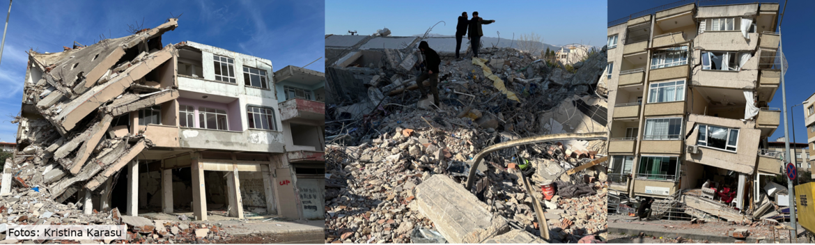
It is one of the most devastating natural events of the 21st century: around 60,000 people died and more than twice as many were injured when the earth shook a year ago. In the early hours of February 6, 2023, a very strong earthquake with a magnitude of 7.8 hit eastern Türkiye and northern Syria. This was followed nine hours later by a magnitude 7.5 quake and numerous aftershocks.
There were some special features to this series of earthquakes, some of which were expected from a research perspective. For example, the region was known as a risk area for a severe earthquake and was shown accordingly on hazard maps (Danciu et al., 2021). What was surprising, however, was that two such severe earthquakes occurred in quick succession.
What surprised the researchers most, however, was the extent of the casualties. There were current models from 2020 that assumed an earthquake with a magnitude very close to the actual magnitude of February 2023. Models used to derive the 2020 European risk map (Crowley et al., 2021) predicted a total of 15,000 fatalities for Türkiye for both events - in reality, there were more than three times as many: 51,000 fatalities in Türkiye alone (Weatherill et al., 2023). In the months that followed, intensive research was carried out into the mechanisms and characteristics of the earthquake series.
We have compiled some questions and answers for you here, together with the relevant studies.
Why did it shake so badly there?
Türkiye is crossed by two large active seismic zones. The quakes on February 6 occurred along the East Anatolian Fault Zone (EAFZ). This is where the Anatolian and Arabian plates meet and move sideways past each other at a speed of around 1.4 cm/year (Bulut et al, 2012). This friction causes earthquakes, some of them strong, to occur at irregular intervals.
Patricia Martínez-Garzón, working group leader in the Geomechanics and Scientific Drilling Section, says: “The last M 7.0 earthquake along this portion of EAFZ occurred about 200 years ago. The entire zone has therefore built up tension over this long period and it was a matter of time until another large M > 7 earthquake would occur. Therefore, the area was well monitored with many measuring instruments there.”
Contact: Dr Patricia Martínez-Garzón
Working group leader in GFZ Section 4.2 “Geomechanics and Scientific Drilling”
patricia.martinez.garzon@gfz-potsdam.de
What was so special about the second quake?
The first quake occurred on a fault zone that was known to be active. The southwestern part of this eastern Anatolian fault zone was activated over a length of about 370 kilometers and from the surface to a depth of about 20 kilometers.
Patricia Martínez-Garzón, working group leader in the Geomechanics and Scientific Drilling Section, says: “Northwest of the first earthquake focus on the East Anatolian Fault Zone, there is a kind of side branch of the fault that was considered tectonically inactive at present. The second quake with a magnitude of 7.5 occurred there. There were fewer measuring instruments in this region, which was considered to be less active. The second quake was so strong that the tremors destroyed many of the buildings that had already been damaged by the first quake.”
Contact: Dr Patricia Martínez-Garzón
Working group leader in GFZ Section 4.2 “Geomechanics and Scientific Drilling”
patricia.martinez.garzon@gfz-potsdam.de
Why did so many people die?
Researchers working on earthquake preparedness had simulated a magnitude 7.6 quake on the East Anatolian fault zone in models. They had reckoned with a third of the actual victims.
Fabrice Cotton, Head of the Seismic Hazards and Dynamic Risks Section, quotes a guiding principle of earthquake research: “Earthquakes do not kill people, buildings do.” He adds: “That's why there were building standards in regions at risk. However, these are not applied equally well everywhere, and there are also buildings that were erected before the stricter standards came into force. The second earthquake, which permanently destroyed previously damaged houses, was an additional harmful factor. Nevertheless, future model calculations will have to be adapted to the actual building stock even more precisely than before. Future models will also to take into account the effects of cumulated damages due to a series of earthquakes.”
Contact: Prof. DrFabrice Cotton
Head of GFZ section 2.6 “Seismic Hazard and Risk Dynamics”
fabrice.cotton@gfz-potsdam.de
What has research learned from the series of earthquakes?
There are several important lessons to be learned from the disaster:
Firstly, it is not yet possible to reliably identify precursor phenomena that would allow the population to be warned exactly before a large quake occurs. However, there are indications of a “preparation process”.
Grzegorz Kwiatek, working group leader in the Geomechanics and Scientific Drilling Section, says: “The analysis of the spatio-temporal distribution of regional seismicity led to the observation of an eight-month preparation process of the crust in the region around the epicenter. This indicates a high and, more importantly, increasing seismic hazard in this region. Such spatio-temporal focusing of seismicity is known from controlled rock deformation experiments in the laboratory and this is what we observed there before the rupture of the rock sample. A similar phenomenon has occurred in several, but by no means all, large earthquakes along continental fault zones in recent decades.”
Marco Bohnhoff, Head of the Geomechanics and Scientific Drilling Section, says: “Our studies show that, based on suitable measurements and regionally dense instrumentation, it is possible in principle to identify the locations of some potential future earthquakes months before they occur. This provides local authorities with important information to improve the resilience of population centers near active faults."
Read more:https://www.gfz-potsdam.de/en/press/news/details/tuerkei-beben-2023-die-analyse
Secondly, smartphones may help to issue early warnings and assess the consequences of an earthquake earlier than conventional measurements when seismological networks are sparse or not designed to provide early warnings.
At the Berlin Falling Walls conference in November 2023, Fabrice Cotton presented a study by his colleague Francesco Finazzi from the University of Bologna, in which he himself was involved. According to the study (paper currently in revision), the app “EQN” developed by the University of Bologna can measure and report vibrations and thus provide an early warning. The first quake in Türkiye was detected after ten seconds. Therefore, for more distant cities that were hit hard, there was an advance warning time of up to one minute because earthquake waves propagate slower than warning signals: One minute to maybe seek shelter under door frames, run outside or turn traffic lights to red in front of bridges etc. Tests are actually performed to evaluate the potential and limits of such new, smartphone-based, early warning technologies.
Another app (“lastquake” from EMSC) and its more than 1,000 users near the epicenter were able to evaluate the level of shaking of the earthquake within ten minutes. Methods have been developed at the GFZ to explore the use of this new type of data and evaluate in a fast way (10 minutes) the impact of earthquakes (Lilienkamp et al., 2023).
A third lesson is that models which simulate the effects (i.e. the impact) must reflect the actual conditions of local regulations, compliance with them and people's behavior even more than before in order to arrive at more reliable statements about the expected extent. Only in this way can disaster services prepare for the inevitable.
Fourthly, the dense instrumentation of the region at risk and the provision of data by the Turkish authorities even covering the previous year have provided very valuable insights for research.
Contacts:
Prof. Dr Marco Bohnhoff
Head of GFZ Section 4.2 “Geomechanics and Scientific Drilling”
marco.bohnhoff@gfz-potsdam.de
Prof. Dr Fabrice Cotton,
Head of GFZ Section 2.6 “Seismic Hazard and Risk Dynamics”
fabrice.cotton@gfz-potsdam.de
Will it be possible to predict such events in the future?
The variability of the various processes observed before earthquakes and the difficulty of distinguishing precursor phenomena that lead to earthquakes from other, irrelevant signals continue to pose major challenges. A medium-term earthquake warning months in advance – if possible at all – still lies in the future of seismology.
However, in order to get closer to this goal step by step, researchers at the GFZ are currently developing refined methods, using artificial intelligence and attempting to close the gap between laboratory experiments and large quakes through field tests. A basic prerequisite for this is to reduce the so-called observation gap, i.e. to set up very dense local measuring networks in earthquake-prone areas in order to be able to record the processes underground more precisely.
Original publications:
Bindi, D., Zaccarelli, R., Cotton, F., Weatherill, G., Reddy Kotha, S. (2023): Source Scaling and Ground-Motion Variability along the East Anatolian Fault. - The Seismic Record, 3, 4, 311-321.
doi.org/10.1785/0320230034
Crowley H., Dabbeek J., Despotaki V., Rodrigues D., Martins L., Silva V., Romão, X., Pereira N., Weatherill G. and Danciu L. (2021) European Seismic Risk Model (ESRM20), EFEHR Technical Report 002, V1.0.0, 84 pp
https://doi.org/10.7414/EUC-EFEHR-TR002-ESRM20
Danciu, L., Nandan, S., Reyes, C. G., Basili, R., Weatherill, G., Beauval, C., ..., Cotton F., Wiemer, S. & Giardini, D. (2021). The 2020 update of the European Seismic Hazard Model-ESHM20: Model Overview. EFEHR Technical Report, 1.
https://doi.org/10.3929/ethz-b-000590386
Karasözen, E., Buyukakpinar, P., Ertuncay, D., Havazlı, E., Oral, E. (2023): A call from early‑career Turkish scientists: seismic resilience is only feasible with “earthquake culture”. - Seismica, 2, 3.
doi.org/10.26443/seismica.v2i3.1012
Kwiatek, G., Martínez-Garzón, P., Becker, D., Dresen, G., Cotton, F., Beroza, G. C., et al. (2023). Months-long seismicity transients preceding the 2023 MW 7.8 Kahramanmaraş earthquake, Türkiye. Nature Communications, 14(1), 7534.
https://doi.org/10.1038/s41467-023-42419-8
Lilienkamp, H., Bossu, R., Cotton, F., Finazzi, F., Landès, M., Weatherill, G., & von Specht, S. (2023). Utilization of Crowdsourced Felt Reports to Distinguish High‐Impact from Low‐Impact Earthquakes Globally within Minutes of an Event. The Seismic Record, 3(1), 29-36.
https://doi.org/10.1785/0320220039
Petersen, G., Buyukakpinar, P., Orlando, F., Sanhueza, V., Metz, M., Cesca, S., Akbayram, K., Saul, J., Dahm, T. (2023): The 2023 SE Türkiye seismic sequence: Rupture of a complex fault network. - The Seismic Record, 3, 2, 134-143.
doi.org/10.1785/0320230008
Weatherill, G., Cotton, F., Crowley, H., Danciu, L., Sesetyan, K., Cakti, E., ... & Türker, E. (2023). The 6 February 2023 Türkiye Earthquakes: Insights for the European Seismic Hazard and Risk Models (No. EGU23-17610). Copernicus Meetings.
https://doi.org/10.5194/egusphere-egu23-17610


![[Translate to English:] Totes Meer gesehen von einem Hügel am Ufer](/fileadmin/_processed_/0/f/csm_20240612-web_AdobeStock_151245578_51e52eaca1.webp "[Translate to English:]")


![[Translate to English:] Gruppenfoto im Hörsaal](/fileadmin/_processed_/8/a/csm_240528-GfZ-ERC-Grantees-Gruppe_3708838bf1.webp)

![[Translate to English:] Drohne](/fileadmin/_processed_/b/a/csm_20240515_155801_04bcccd740.webp "[Translate to English:]")


