

Summary
Since 20 March, a newly completed, unique network of particularly sensitive borehole seismometers has been recording an unusual earthquake swarm in the Vogtland region near Klingenthal, on the border between the Czech Republic and Germany, for the first time since 1962. In the first 14 days, the new measuring stations have already registered thousands of earthquakes with magnitudes between 0 and 2.6 at a depth of eight to ten kilometres. This provides unique data for analysing the causes of earthquake swarms in the Vogtland region. The new type of swarm earthquake monitoring network consists of five boreholes up to 400 metres deep, which have been equipped with particularly sensitive seismometers. It was set up as part of an International Continental Drilling Programme (ICDP) project by an international scientific consortium led by the GFZ German Research Centre for Geosciences.
Earthquake swarm in the Vogtland
“The current earthquake swarm is unusual in several respects, not only because it has already lasted more than 14 days, but also because it is the first swarm in the most active region around Novy Kostel to occur so far north and partly affect German territory,” says Torsten Dahm, Head of the GFZ Section “Earthquake and Volcano Physics” and Professor of Geophysics at the University of Potsdam, who is leading the project on behalf of the GFZ. “The shape of the earthquake swarm at a depth of around 10 kilometres is also unusual, as the quakes activate a horizontal, circular structure for the first time. We have never seen a pattern like this in the Vogtland before,” says Dahm, who is now working with colleagues to further analyse these quakes.
Swarm earthquakes are a sequence of a large number of earthquakes of similar magnitude that occur in certain regions over periods of several days, weeks or months. They occur worldwide, especially in volcanically active regions. It is therefore assumed that they are triggered by fluid movements underground.
The Saxon region between Bad Brambach, Plauen and Oelsnitz is regularly affected by earthquake swarms, which are associated with magmatic processes in the earth's mantle and crust. The current swarm near Klingenthal lies to the north of the most active swarm earthquake zone in the region near Novy Kostel in the Czech Republic, which has expanded both to the south and to the north in recent years. The extent of this zone is therefore already more than 15 kilometres long.
“The phenomena in this region are of scientific interest worldwide, as the Vogtland is a rare example of studying the formation of magmatic-volcanic processes and earthquake swarms in the Earth's crust far from tectonic plate boundaries,” explains Dahm. However, the phenomena and processes only generate weak signals and are difficult to measure, which is why there are special requirements for a monitoring network.
New “ICDP-Eger” infrastructure for permanent monitoring in the Vogtland and Bohemia
For this reason, an international scientific consortium was founded in 2015 under the leadership of the GFZ to improve the sensitivity of the seismic monitoring networks and establish a permanent monitoring programme for the region. In addition to other institutions from Germany, such as the Universities of Potsdam and Leipzig, the University of Prague and the Academy of Sciences from the Czech Republic are also represented, as are partners from the University of Aarhus (Denmark) and the US Geological Survey (USA). The ICDP project “Drilling the Eger Rift: Magmatic fluids driving the earthquake swarms and the deep biosphere” was approved in 2016.
The planning, approval and implementation took many years, with 25 per cent of the operational costs being provided by the ICDP, which is coordinated by a team of GFZ scientists, technicians and engineers. The remaining 75% was co-financed by other donors (including the DFG's ICDP Priority Programme).
The installation of the monitoring network: drilling and equipping with measuring devices and special seismometers
Various boreholes were planned in the project application, both for fluid analyses and for seismic monitoring.
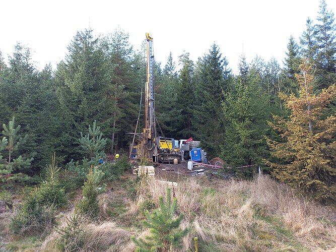
The so-called mofette drilling (F3) began in August 2019 and reached a depth of 239 metres. It is located in the Nord HartoušovCO2 mofette in the Eger Basin in the Czech Republic, around 10 kilometres east of Bad Brambach. Mofettes are natural escape channels forCO2 from the earth's interior. “The drilling was difficult because it was the first time that such a deep hole had been drilled into an activeCO2 mofette under overpressure,” explains Heiko Woith, a scientist in the GFZ's “Physics of Earthquakes and Volcanoes” section, who coordinated the fluid drilling. The drilling and casing were successfully completed in September 2019.
The well, together with two previous monitoring sites, forms a unique fluid observatory of three neighbouring shallow wells within an activeCO2 mofette to continuously record fluid composition, isotopic signature (δ13CCO2, δ18OCO2) and fluid fluxes at a depth of 30 to 229 metres. After COVID-related delays, most of the required sensor/acquisition systems are now installed and continuous monitoring is underway. The data streams have been available to the consortium since autumn 2020. In addition, drill cores have been collected over the entire drilling depth and are currently being analysed by the GFZ microbiology teams.
Unique seismological antenna
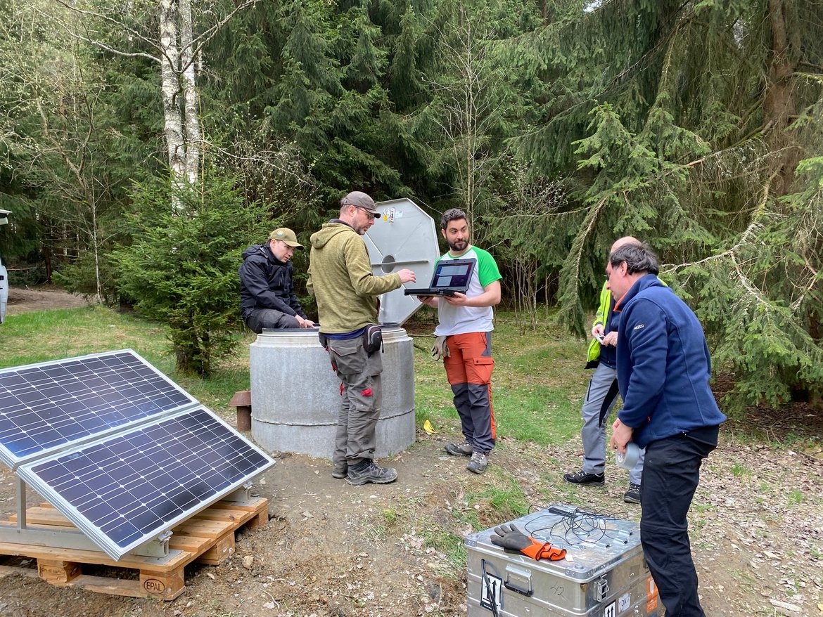
Boreholes S1 to S4 house the seismological instrumentation at a depth of up to 400 metres. The instrumentation comprises 8 or 10-element high-frequency geophone chains and broadband sensors at the bottom of the boreholes.
The borehole at Landwüst (S1) was also supplemented by a network of 15 high-sensitivity surface stations with a diameter of around 400 metres. “This is a globally unique configuration of a three-dimensional, seismological antenna in the middle of a swarm earthquake area,” says Matthias Ohrnberger, a scientist at the University of Potsdam, who designed the geometry of the 3D array. “With this configuration, we can now try out new methods for investigating very small earthquakes.”
The boreholes at Studenec (S3), Tisova/Klingenthal (S2) and Liba (S4) could be equipped with the seismic sensors in autumn 2023 and April 2024.
The data is available to the scientific community via the GEOFON data portal, among others
The continuous, high-frequency data (400 or 1000 Hertz sampling rate) from the four seismological boreholes are all brought together in the GEOFON data portal at the GFZ and are also sent to the University of Potsdam and the seismological services in Saxony, which are involved in the research project. They are freely available to the scientific community together with the data from the surrounding seismic networks (virtual EGER network, doi:10.14470/SN852091). “This is the first time that the data from the Eger ICDP borehole network has been made fully available,” says Torsten Dahm.
New scientific opportunities thanks to the ICDP-Eger borehole network
In 2024, two third-party funded projects funded by the German Research Foundation (DFG) at the GFZ and the University of Potsdam will be launched to improve the evaluation of earthquake activity in the entire region, which will also incorporate earlier measurement data. “We are applying a specially developed detection algorithm to the new digital data that works with concepts of machine learning and artificial intelligence,” says junior scientist Pinar Büyükakpinar from the GFZ's “Physics of Earthquakes and Volcanoes” section, who acquired one of the projects herself. “This allows us to identify more earthquakes than with previous methods and, above all, we can also see small swarm earthquakes in places where only a few earthquakes were previously measured.”
Scientific publications related to the project:
Dahm, T., Hrubcová, P., Fischer, T., Horálek, J., Korn, M., Buske, S., Wagner, D. (2013): Eger Rift ICDP: an observatory for study of non-volcanic, mid-crustal earthquake swarms and accompanying phenomena. - Scientific drilling: reports on deep earth sampling and monitoring, 16, 93-99
https://doi.org/10.5194/sd-16-93-2013
Fischer, T., Hrubcová, P., Dahm, T., Woith, H., Vylita, T., Ohrnberger, M., Vlček, J., Horálek, J., Dědeček, P., Zimmer, M., Lipus, M.P., Pierdominici, S., Kallmeyer, J., Krüger, F., Hannemann, K., Korn, M., Kämpf, H., Reinsch, T., Klicpera, J., Vollmer, D. & Daskalopoulou, K., 2022. ICDP drilling of the Eger Rift observatory: magmatic fluids driving the earthquake swarms and deep biosphere, Sci. Dril., 31, 31-49, doi: 10.5194/sd-31-31-2022
https://doi.org/10.5194/sd-31-31-2022
Woith, H., Daskalopoulou, K., Zimmer, M., Fischer, T., Vlček, J., Trubač, J., Rosberg, J.-E., Vylita, T. & Dahm, T., 2020. Multi-Level Gas Monitoring: A New Approach in Earthquake Research, Frontiers in Earth Science, 8, 585733, doi: 10.3389/feart.2020.585733
https://doi.org/10.3389/feart.2020.585733
Woith, H., Vlček, J., Vylita, T., Dahm, T., Fischer, T., Daskalopoulou, K., Zimmer, M., Niedermann, S., Stammeier, J.A., Turjaková, V. & Lanzendörfer, M., 2022. Effect of Pressure Perturbations on CO2 Degassing in a Mofette System: The Case of Hartoušov, Czech Republic, Geosciences, 13, doi: 10.3390/geosciences13010002
https://doi.org/10.3390/geosciences13010002


![[Translate to English:] Totes Meer gesehen von einem Hügel am Ufer](/fileadmin/_processed_/0/f/csm_20240612-web_AdobeStock_151245578_51e52eaca1.webp "[Translate to English:]")


![[Translate to English:] Gruppenfoto im Hörsaal](/fileadmin/_processed_/8/a/csm_240528-GfZ-ERC-Grantees-Gruppe_3708838bf1.webp)

![[Translate to English:] Drohne](/fileadmin/_processed_/b/a/csm_20240515_155801_04bcccd740.webp "[Translate to English:]")


