Join in the research: Citizen Science
Citizen Science is research that is actively supported by people who do not work professionally as scientists. Often, committed participants support research activities organized by scientists from research centres and universities, but citizens sometimes even organise their own scientific work. Citizen science is distinct from science communication or education in that citizen science always aims to answer a currently open scientific question. Citizen scientists can also be involved in setting the scientific agenda and designing research projects, especially in cases where the science question has a strong social relevance.
Citizen science projects are often initiated when it is necessary to collect or evaluate large or spatially distributed amounts of data, to verify data measured by other means (e.g. satellites), or to collect data that have to be collected immediately or over a long period of time.
Why is the data collected by citizens interesting for science?
For scientific surveys, we often have highly specialised and precise sensors. However, human perceptions - despite their natural limitations - have some advantages: they can provide data that complement, or in some cases cannot be captured by sensors. For example, sensor networks are sometimes spread too far apart, and cannot observe events that occur between them. Satellite measurements are another example. Satellites only provide data of the part of Earth that they overfly. This means, for example, that they often only observe at a specific time of day. Humans can therefore provide valuable supplementary data, both because they can observe at different times and places, but also because they can examine the environment from their different perspective at the Earth’s surface.
It also happens that measuring stations can be destroyed, for example when river discharge gauges are swept away by a flood. In such cases, observations by people are particularly valuable. Sensors usually only record certain predefined features and perspectives; people with their perception, on the other hand, are able to fill in missing features and react flexibly. In some cases, it is also a matter of speed: as eyewitnesses to an event, people can provide up-to-date data more quickly than is possible for researchers.
There are therefore many opportunities for human volunteers to provide valuable data that cannot be obtained in other ways.
.
Humans collect "better" data in some cases
There are some cases, particularly when human senses such as smell and vision are concerned, where human observations are easier to interpret than measurements by sensors. An example of such a situation where the GFZ has been active is in outdoor lighting transitions. Because human vision shifts between a daytime mode and nighttime mode (with peak sensitivity moving from the green towards the blue), observations of streets or the night sky taken by cameras or satellites do not match the experience of humans on the ground.
Current satellite observations are strongly affected by a problem that when cities switch from orange sodium lamps to white LEDs, the change in brightness reported by satellite strongly disagrees with that reported by human observers. A related problem is that satellites view light directed upwards, but not light directed towards the side (such as from a billboard with a video display). Data from human observers in a range of citizen science experiments therefore complement the satellite data, and help us to better understand it.
News: Nachtlicht-BüHNE in the Year of Science 2023
Citizen Science activities receive project funding from Helmholtz Innovation Pool
Nachtlicht-BüHNE
In 2019, the Helmholtz Think Tank initiated funding for new exciting projects with a citizen science approach. For three years, these projects were funded from the President's Initiative and Networking Fund. One of the winners was the Citizen Helmholtz Network for research on nocturnal light phenomena, in which the German Research Centre for Geosciences Potsdam (GFZ), the German Aerospace Center (DLR) and the Helmholtz Centre for Environmental Research (UFZ) are involved. Now a new phase of the project with revised research questions has begun as part of the Year of Science 2023.
In two pilot studies on the topics of light pollution and meteor research, a co-design approach for app-based citizen science projects is being developed together with citizens in the project Nachtlicht-BüHNE. The aim is to record all lights in a predefined space of a city. Co-design means that Helmholtz scientists worked together with citizen scientists to jointly develop and implement the project, as well as publish its results.
Loss of the Night | App for Recording the Brightness of the Sky
This citizen science project investigates which stars can still be seen in the sky in urban areas, and thus how much light pollution there is. It works by guiding participants to certain stars, and asking if the stars can be seen by the naked eye. The brightness of the faintest star that is still visible provides information about how bright the sky is. In regions without artificial light sources, up to 6000 stars can still be discovered at night. In Berlin, only a few hundred stars can be seen.
The aim of the project is to find out how sky brightness changes over the years due to light pollution.
To the app: Loss of the Night | Status: finished
“My Sky at Night” | Map Light Pollution
"My Sky at Night" visualises satellite measurements of light pollution all over the world on a map. With help from the star counters (citizen scientists), the scientists at the GFZ also want to find out in which direction light pollution is changing - for example, due to the worldwide change in illuminants in street lamps from sodium vapour lamps to LEDs.
About the project: My Sky at Night
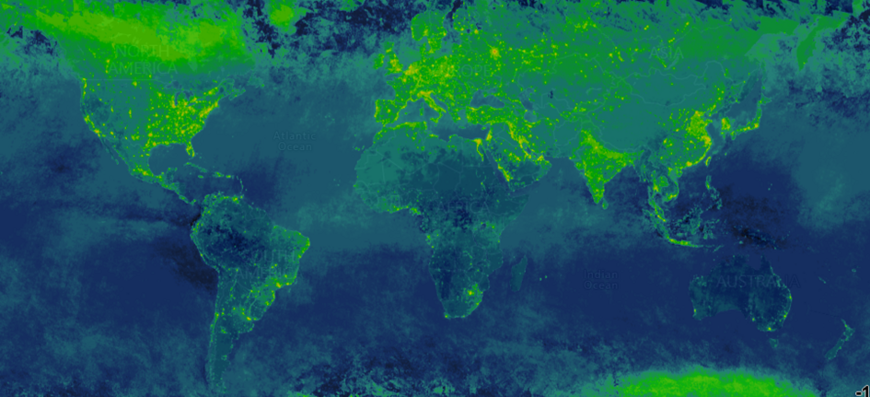
Radiance Light Trends
Satellite data are often available free of charge on the internet and can be downloaded by anyone. In most cases, however, people don’t know where to find it, or how to deal with the extremely large files. As part of the Horizon 2020 project "GEO-Essential", the GFZ led the development of a web application that allows citizen scientists to access satellite data and conduct their own analyses. In the web application "Radiance Light Trends", regions of interest can be drawn in, a satellite can be selected and within a few moments a diagram of the monthly or annual changes in artificial light emissions can be viewed. The region that was created for the analysis can also be downloaded to enable repeated analysis in the future. The code underlying this app has been released under the Open Source Licence for the European Union (EUPL) and could be adapted in the future to any other satellite time series, such as sea and land ice cover or plant phenology.
About the project: Radiance Light Trends | Status: ongoing
AgriSens - Demmin 4.0: Use of remote sensing technologies for digitalisation in crop production
AgriSens - Demmin 4.0 serves the use of geoinformation in crop production. The project coordinator is the GFZ. In the project, the GFZ leads work package 2 of the data innovation pool and focuses on the fusion of satellite data from different sensors for agricultural issues. The project also has a citizen science component. Scientists from DLR and the University of Jena are developing citizen science strategies that involve farmers in the data collection. In this way, for example, local knowledge can be collected for the mapping of low-yield areas.
To the project: AgriSens - Demmin 4.0 | Status: ongoing
PostDistiller: Rapid information in the event of flooding
One problem in recording the extent of flooding so far is that traditional data sources such as remote sensing data from satellites are not immediately available. Especially in urban areas, however, it is of particular importance that information on the flooding situation is available quickly. Rescuers need to get an overview in order to be able to initiate rescue operations and limit possible further damage.
However, many users of social media are active, especially in residential areas. Photos from affected areas are usually taken by eyewitnesses as soon as a catastrophic event begins and shared via social networks such as Twitter or Flickr. A team of scientists led by Prof. Doris Dransch, GFZ Geoinformatics Section, and Dr. Kai Schröter, formerly of the Hydrology Section, developed the software PostDistiller, which uses posts from social networks to help record the extent of a flood.
About the project PostDistiller | Status: completed
Record local water quality: PALESCA
Citizen science approaches are increasingly being used in Kyrgyzstan as part of paleoclimate studies at the GFZ Global Change Observatory in Central Asia. Through the project PALESCA, which was completed in 2019, smartphones with corresponding sensors and water chemistry test kits as well as weather stations were handed over to local schools in the Jalalabad region. These are used to collect data on local water quality in addition to meteorological parameters. Recently, the smartphone app "CrowdWater" developed by the University of Zurich has also been used for hydrological measurement series.
About the project PALESCA | Status: completed
To the app CrowdWater | Status: ongoing
Overview | Citizen Science Projects in Germany, Austria and Switzerland
At the Helmholtz Research Centres
In Germany, Austria and Switzerland
- «Bürger schaffen Wissen» is the central platform for Citizen Science in Germany and presents, networks and supports Citizen Science projects. Bürger schaffen Wissen sees it as its task to further develop citizen science in Germany, to make it better known and to provide information about projects to participate in.
- Austrian Citizen Science Platform
- Swiss Citizen Science Platform


