

The GFZ spectroscopy laboratory supports advances in optical and thermal remote sensing for the definition of new sensors for spaceborne missions, for the development of methodologies toward improved surface properties characterization, and for the development of standards and protocols. We are focusing on the geosphere applications (minerals and soils), agricultural areas, and arid regions of the world (deserts, arctic) that are subject to erosion and degradation under climate change.
For punctual high-spectral resolution measurements we have two Perkin-Elmer laboratory spectroradiometers, a Lambda 950 for the VNIR-SWIR and a Spextrum GX FTIR for the thermal range. With these instruments we are able to spectrally investigate a wide range of materials (liquids, powders, pressed tablets, loose soil material, solid objects). We are also equipped with multiple VNIR-SWIR and FTIR field spectroradiometers (e.g. ASD FieldSpec, Spectral evolution PSR+, Agilent 4300 Handheld FTIR) that can be used in the laboratory for standard measurements. Additionally, we use a Goniometer for BRDF-Analyses and a Dark Box for standardized soil spectral library measurements. For further developments toward soil data harmonization, we lead the IEEE-SA P4005 Working group on Standards and protocols for soil spectroscopy . Also, the GFZ spectroscopy laboratory is a member of the Global Soil Laboratory Network GLOSOLAN of the FAO.
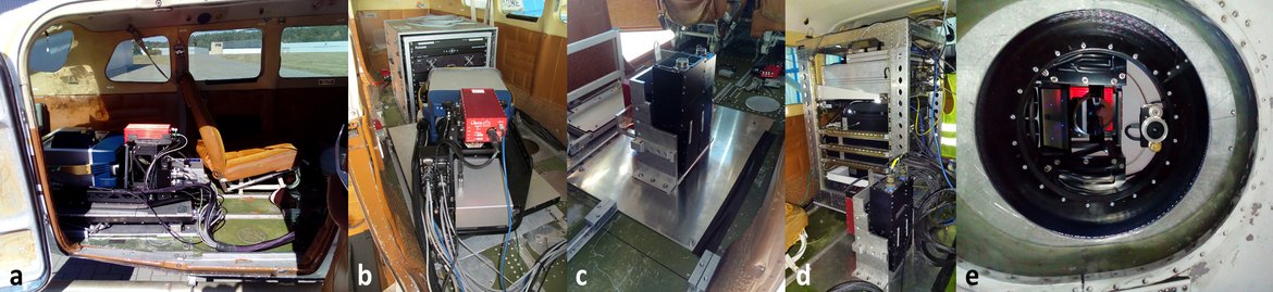
For planar measurements in the laboratory, in the field or by plane, we have two hyperspectral line scan cameras from HySpex, the VNIR-1600 and the SWIR-320m-e, and a Telops HyperCam LW. In the laboratory, the HySpex sensors are mounted in a modular adjustable rack. Image acquisition is achieved by moving the samples on a translation stage. Different lenses can be used to achieve different spatial resolutions in the laboratory, including a microscope lens which allows a spatial resolution of only 1 µm. The Telops HyperCam is an imaging FTIR spectrometer operating in the LWIR (7.7 - 11.8 µm), that was recently acquired for the MOSES event chain Heatwave.

For in-situ measurements in the field, we use portable field spectroradiometers (ASD FieldSpec Pro, Spectral Evolution PSR+) for the VNIR and SWIR spectral region, and 1 GER instrument in the VNIR region (for water bodies and arctic regions). For the long-wave infrared region, we use an Agilent 4300 Handheld FTIR. In the field the HySpex and the HyperCam hyperspectral cameras are mounted on a tripod. For the HySpex sensors, the horizontally recorded image is created by the rotating movement of the tripod.

For UAV and airborne measurements, we mount our devices on adapted platforms. For airborne measurements, we mount our vis/NIR and thermal hyperspectral cameras (HySpex VNIR and SWIR, HyperCam LW) on airborne carrier. For UAV measurements, several Vis/NIR multispectral (Tetracam Mini MCA, MicaSense RedEdge M) and hyperspectral cameras (HySpex Mjolnir SWIR-620, Cubert VNIR) are provided, along with thermal cameras (Optris PI450, InfraTec Vario Cam).
In addition, we have various instruments for in-situ characterization of surface properties (minerals, soils, vegetation) for calibration and validation of flight data:
- SunScan LAImeter
- Chlorophyll sensor (DUALEX Scientific, SPAD 502 Plus)
- Pyrometer, soil moisture sensors
- Surface and air temperature sensors
- Niton XL3t XRF, LIBS
- Handheld GPS
- terrestrial 3D laserscanner
Publications
Based on measurements in the lab
Chabrillat, S., Gholizadeh, A., Neumann, C., Berger, D., Milewski, R., Ogen, Y., Ben-Dor, E. (2019): Preparing a soil spectral library using the Internal Soil Standard (ISS) method: Influence of extreme different humidity laboratory conditions. - Geoderma, 355. doi.org/10.1016/j.geoderma.2019.07.013
Milewski, R., Chabrillat, S., Brell, M., Schleicher, A. M., Guanter, L. (2019): Assessment of the 1.75 μm absorption feature for gypsum estimation using laboratory, air- and spaceborne hyperspectral sensors. - International Journal of Applied Earth Observation and Geoinformation, 77, 69-83. doi.org/10.1016/j.jag.2018.12.012
Ogen, Y., Neumann, C., Chabrillat, S., Goldshleger, N., Ben Dor, E. (2018): Evaluating the detection limit of organic matter using point and imaging spectroscopy. - Geoderma, 321, 100-109. doi.org/10.1016/j.geoderma.2018.02.011
Rogass, C., Koerting, F.M., Mielke, C., Brell, M., Boesche, N.K., Bade, M., Hohmann, C., 2017. Translational Imaging Spectroscopy for Proximal Sensing. Sensors 17. doi.org/10.3390/s17081857
Körting, F., Rogaß, C., Kämpf, H., Lubitz, C., Harms, U., Schudack, M., Kokaly, R., Mielke, C., Bösche, N., Altenberger, U. (2015): Drill core mineral analysis by means of the hyperspectral imaging spectrometer HySpex, XRD and ASD in proximity of the Mytina MaarR, Czech Republic. - ISPRS - The International Archives of Photogrammetry, Remote Sensing and Spatial Information Sciences, XL-1-W5, 417-424. doi.org/10.5194/isprsarchives-XL-1-W5-417-2015
Eisele, A., Chabrillat, S., Hecker, C., Hewson, R., Lau, I. C., Rogaß, C., Segl, K., Cudahy, T. J., Udelhoven, T., Hostert, P., Kaufmann, H. (2015): Advantages using the thermal infrared (TIR) to detect and quantify semi-arid soil properties. - Remote Sensing of Environment, 163, 296-311. doi.org/10.1016/j.rse.2015.04.001
Brosinsky, A., Förster, S., Segl, K., Kaufmann, H. (2014): Spectral fingerprinting: sediment source discrimination and contribution modelling of artificial mixtures based on VNIR-SWIR spectral properties. - Journal of Soils and Sediments, 14, 12, 1949-1964. doi.org/10.1007/s11368-014-0925-1
Brosinsky, A., Förster, S., Segl, K., López-Tarazón, J. A., Pique, G., Bronstert, A. (2014): Spectral fingerprinting: characterizing suspended sediment sources by the use of VNIR-SWIR spectral information. - Journal of Soils and Sediments, 14, 12, 1965-1981. doi.org/10.1007/s11368-014-0927-z
Based on measurements in the field (ground, UAV, airborne)
Milewski, R., Chabrillat, S., Bookhagen, B. (2020): Analyses of Namibian Seasonal Salt Pan Crust Dynamics and Climatic Drivers Using Landsat 8 Time-Series and Ground Data. - Remote Sensing, 12, 3. doi.org/10.3390/rs12030474
Castaldi, F., Chabrillat, S., van Wesemael, B. (2019): Sampling Strategies for Soil Property Mapping Using Multispectral Sentinel-2 and Hyperspectral EnMAP Satellite Data. - Remote Sensing, 11, 3. doi.org/10.3390/rs11030309
Castaldi, F., Hueni, A., Chabrillat, S., Ward, K., Buttafuoco, G., Bomans, B., Vreys, K., Brell, M., van Wesemael, B. (2019): Evaluating the capability of the Sentinel 2 data for soil organic carbon prediction in croplands. - ISPRS Journal of Photogrammetry and Remote Sensing, 147, 267-282. doi.org/10.1016/j.isprsjprs.2018.11.026
Milewski, R., Chabrillat, S., Brell, M., Schleicher, A. M., Guanter, L. (2019): Assessment of the 1.75 μm absorption feature for gypsum estimation using laboratory, air- and spaceborne hyperspectral sensors. - International Journal of Applied Earth Observation and Geoinformation, 77, 69-83. doi.org/10.1016/j.jag.2018.12.012
Neumann, C., Behling, R., Schindhelm, A., Itzerott, S., Weiss, G., Wichmann, M., Müller, J. (2019): The colors of heath flowering – quantifying spatial patterns of phenology in Calluna life‐cycle phases using high‐resolution drone imagery. - Remote Sensing in Ecology and Conservation, [early online release]. doi.org/10.1002/rse2.121
Brell, M., Segl, K., Guanter, L., Bookhagen, B., 2019. 3D hyperspectral point cloud generation: Fusing airborne laser scanning and hyperspectral imaging sensors for improved object-based information extraction. ISPRS J. Photogramm. Remote Sens. 149, 200–214. doi.org/10.1016/j.isprsjprs.2019.01.022
Elizabeth C. Atwood, Francesco M. Falcieri, Sarah Piehl, Mathias Bochow, Michael Matthies, Jonas Franke, Sandro Carniel, Mauro Sclavo, Christian Laforsch, Florian Siegert, Coastal accumulation of microplastic particles emitted from the Po River, Northern Italy: Comparing remote sensing and hydrodynamic modelling with in situ sample collections, Marine Pollution Bulletin, Volume 138, 2019, Pages 561-574, ISSN 0025-326X, doi.org/10.1016/j.marpolbul.2018.11.045
Kuester, T., Spengler, D. (2018): Structural and Spectral Analysis of Cereal Canopy Reflectance and Reflectance Anisotropy. - Remote Sensing, 10, 11. doi.org/10.3390/rs10111767
Beamish, A., Coops, N. C., Hermosilla, T., Chabrillat, S., Heim, B. (2018): Monitoring pigment-driven vegetation changes in a low-Arctic tundra ecosystem using digital cameras. - Ecosphere, 9, 2. doi.org/10.1002/ecs2.2123
L. Katharina Schmidt, Mathias Bochow, Hannes K. Imhof, Sascha E. Oswald, Multi-temporal surveys for microplastic particles enabled by a novel and fast application of SWIR imaging spectroscopy – Study of an urban watercourse traversing the city of Berlin, Germany, Environmental Pollution, Volume 239, 2018, Pages 579-589, ISSN 0269-7491, doi.org/10.1016/j.envpol.2018.03.097.
Beamish, A., Coops, N., Chabrillat, S., Heim, B. (2017): A Phenological Approach to Spectral Differentiation of Low-Arctic Tundra Vegetation Communities, North Slope, Alaska. - Remote Sensing, 9, 11. doi.org/10.3390/rs9111200
Brell, M., Segl, K., Guanter, L., Bookhagen, B., 2017. Hyperspectral and Lidar Intensity Data Fusion: A Framework for the Rigorous Correction of Illumination, Anisotropic Effects, and Cross Calibration. IEEE Trans. Geosci. Remote Sens. 55, 2799–2810. doi.org/10.1109/TGRS.2017.2654516
Coelho, C., Heim, B., Förster, S., Brosinsky, A., de Araújo, J. (2017): In Situ and Satellite Observation of CDOM and Chlorophyll-a Dynamics in Small Water Surface Reservoirs in the Brazilian Semiarid Region. - Water, 9, 12. doi.org/10.3390/w9120913
Milewski, R., Chabrillat, S., Behling, R. (2017): Analyses of Recent Sediment Surface Dynamic of a Namibian Kalahari Salt Pan Based on Multitemporal Landsat and Hyperspectral Hyperion Data. - Remote Sensing, 9, 2. doi.org/10.3390/rs9020170
Spengler, D., Behling, R., Chabrillat, S., Diedrich, H., Dransch, D., Förster, S., Haghshenas Haghighi, M., Hollstein, A., Itzerott, S., Kuester, T., Mielke, C., Milewski, R., Motagh, M., Roessner, S., Scheffler, D., Sips, M., Segl, K., Wolanin, A., Guanter, L. (2017): Satellitenfernerkundung von Landoberflächen – Beginn einer neuen Ära. - System Erde, 7, 2, 38-49. doi.org/10.2312/GFZ.syserde.07.02.6
Brell, M., Rogass, C., Segl, K., Bookhagen, B., Guanter, L., 2016. Improving Sensor Fusion: A Parametric Method for the Geometric Coalignment of Airborne Hyperspectral and Lidar Data. IEEE Trans. Geosci. Remote Sens. 54, 3460–3474. doi.org/10.1109/TGRS.2016.2518930
Neumann, C., Förster, M., Kleinschmit, B., Itzerott, S. (2016): Utilizing a PLSR-Based Band-Selection Procedure for Spectral Feature Characterization of Floristic Gradients. - IEEE Journal of Selected Topics in Applied Earth Observations and Remote Sensing, 9, 9, 3982-3996. doi.org/10.1109/JSTARS.2016.2536199
Neumann, C., Itzerott, S., Weiss, G., Kleinschmit, B., Schmidtlein, S. (2016): Mapping multiple plant species abundance patterns - A multiobjective optimization procedure for combining reflectance spectroscopy and species ordination. - Ecological Informatics, 36, 61-76. doi.org/10.1016/j.ecoinf.2016.10.002
Schmid, T., Rodrίguez-Rastrero, M., Escribano, P., Palacios-Orueta, A., Ben-Dor, E., Plaza, A., Milewski, R., Huesca, M., Bracken, A., Cicuéndez, V., Pelayo, M., Chabrillat, S. (2016): Characterization of soil erosion indicators using hyperspectral data from a Mediterranean rainfed cultivated region. - IEEE Journal of Selected Topics in Applied Earth Observations and Remote Sensing, 9, 2, 845-860. doi.org/10.1109/JSTARS.2015.2462125
Mielke, C., Rogaß, C., Bösche, N., Segl, K., Altenberger, U. (2016): EnGeoMAP 2.0—Automated Hyperspectral Mineral Identification for the German EnMAP Space Mission. - Remote Sensing, 8, 2, 127. doi.org/10.3390/rs8020127
Boesche, N.K., Rogass, C., Lubitz, C., Brell, M., Herrmann, S., Mielke, C., Tonn, S., Appelt, O., Altenberger, U., Kaufmann, H., 2015. Hyperspectral REE (Rare Earth Element) Mapping of Outcrops—Applications for Neodymium Detection. Remote Sens. 7, 5160–5186. doi.org/10.3390/rs70505160
Clasen, A., Somers, B., Pipkins, K., Tits, L., Segl, K., Brell, M., Kleinschmit, B., Spengler, D., Lausch, A., Förster, M. (2015): Spectral Unmixing of Forest Crown Components at Close Range, Airborne and Simulated Sentinel-2 and EnMAP Spectral Imaging Scale. - Remote Sensing, 7, 11, 15361-15387. doi.org/10.3390/rs71115361
Bösche, N., Rogaß, C., Mielke, C., Herrmann, S., Körting, F., Papenfuß, A., Lubitz, C., Brell, M., Tonn, S., Altenberger, U. (2015): Hyperspectral Rare Earth Element Mapping of Three Outcrops at the Fen Complex, Norway: Calcitic, Dolomitic, and Ankeritic Carbonatites. - In: De Lima, I. B., Leal Filho, W. (Eds.), Rare Earths Industry: Technological, Economic, and Environmental Implications, Elsevier Science Publishing, 235-263. doi.org/10.1016/B978-0-12-802328-0.00016-4
Bösche, N., Rogaß, C., Lubitz, C., Brell, M., Herrmann, S., Mielke, C., Tonn, S., Appelt, O., Altenberger, U., Kaufmann, H. (2015): Hyperspectral REE (Rare Earth Element) Mapping of Outcrops - Applications for Neodymium Detection. - Remote Sensing, 7, 5, 5160-5186. doi.org/10.3390/rs70505160
Neumann, C., Weiss, G., Itzerott, S. (2015): Döberitzer Heide 2008/2009 - An EnMAP Preparatory Flight Campaign (Datasets). doi.org/10.5880/enmap.2015.001
Küster, T., Spengler, D., Barczi, J.-F., Segl, K., Hostert, P., Kaufmann, H. (2014): Simulation of Multitemporal and Hyperspectral Vegetation Canopy Bidirectional Reflectance Using Detailed Virtual 3-D Canopy Models. - IEEE Transactions on Geoscience and Remote Sensing, 52, 4, 2096-2108. doi.org/10.1109/TGRS.2013.2258162
Siegmann, B., Glässer, C., Itzerott, S., Neumann, C. (2014): An Enhanced Classification Approach using Hyperspectral Image Data in Combination with in situ Spectral Measurements for the Mapping of Vegetation Communities. - Photogrammetrie - Fernerkundung - Geoinformation (PFG), 2014, 6, 523-533. doi.org/10.1127/pfg/2014/0243


