Precise orbit determination for radar altimetry satellites
Satellite radar altimetry is one of the primary techniques to study sea level changes. It allows measuring absolute sea level heights and variations globally at various time scales. Precise orbits of altimetry satellites are also a prerequisite for the analysis of altimetry measurements, altimetry mission cross-calibration and generation of a mean sea surface model. The list of the major altimetry missions includes past missions GEOSAT (1985-1990), ERS-1 (1991-2000), TOPEX/Poseidon (1992-2005), ERS-2 (1995-2011), GFO (1998-2008), and Envisat (2002-2012), missions Jason-1 (-2013), and current Jason-2 (since 2008), CryoSat-2 (since 2010), HY-2A (since 2011), and Saral (since 2013), JASON-3 (since 2016) and Sentinel-3A (since 2016).
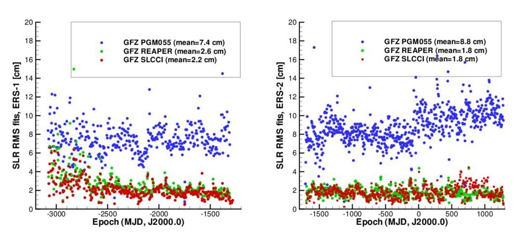
Orbits of altimetry satellites were computed at various institutes using different models in different reference frames in the past. To achieve consistency over longer time periods and reduce systematic effects caused by using different, for different satellites, models and reference frames, the unification of orbit quality is very important. Altimetry satellite precise orbit reprocessing has been performed at GFZ a few times in the past decades using our “Earth Parameter and Orbit System – Orbit Computation” (EPOS-OC) software for various missions within f.i. the following projects: ERS-1 and ERS-2 routine orbit calculation for the European Space Agency (ESA), SEAVAR (2005-2008), REAPER (2009-2010) and SLCCI (2010-2013). Notable progress in precise orbit determination for radar altimetry satellites has been achieved at GFZ in the recent decades. Thus, the root mean square (RMS) fits of Satellite Laser Ranging (SLR) measurements for ERS-1 orbits covering the time span from 1991 till 1996 show an improvement (see Figure, left) from 7.4 cm to 2.2 cm. The improvements of SLR data fits for ERS-2 orbits for the time interval from 1995 till 2003 are even larger (see Figure, right): from 8.8 cm to 1.8 cm.
However, further improvements of the altimetry satellites orbit quality are still desirable and possible. One still open question are about 0.1-0.2 mm/yr differences in the global mean sea level derived from the analysis of ascending and descending tracks of ERS-1, ERS-2 and Envisat orbits computed in the SLCCI project. Additionally, computation of precise orbits of new altimetry missions, such as Cryosat-2, HY-2A, Saral, Sentinel-3 and JASON-3 is expected to contribute significantly to the cross-calibration of altimetry missions and thus to improved altimetry products. Future altimetry missions such as Sentinel-3B planned for 2018, Jason-CS planned for 2020 and Swot to be launched in 2021, together with the current missions will allow long-term study of sea surface heights, global and regional sea level changes and other altimetry investigations. Precise orbits of these missions are an important prerequisite for this research.