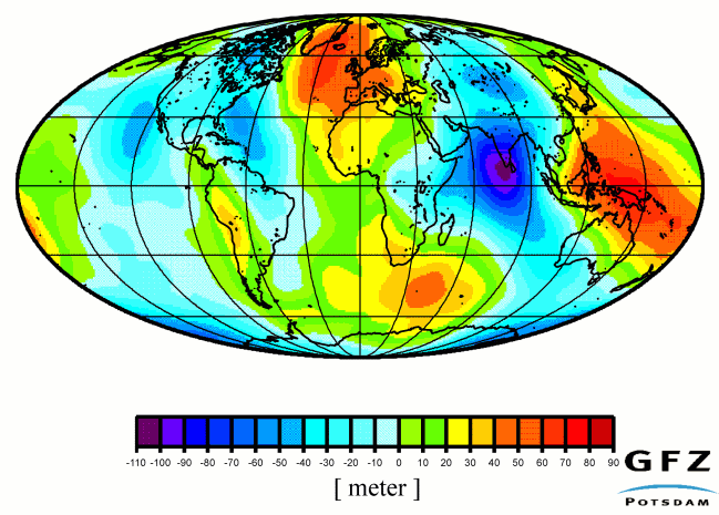
Global models of the gravity field at the surface of the Earth are derived from observed gravitational satellite orbit perturbations. Due to insufficient data coverage and non-optimised orbit configurations, tracking data from three dozens of satellites up to now have to be merged together to get a state-of-the-art global gravity field model from satellite tracking only. Satellite-only models represent, due to the attenuation of the signal at orbit altitude, the broad structure of the global field. Adding terrestrial gravity measurements and altimetry data over the oceans allows to resolve within this given frame the smaller signatures of the Earth's gravity field. Thanks to its dedicated orbit design, an unpreceded low altitude in a (near-) polar orbit, and its continuous GPS satellite-to-satellite tracking capability together with a direct on-board measurement of the non-gravitational orbit perturbations, an improvement of up to two orders of magnitude in accuracy is achieved with CHAMP in the recovery of the broad to mesoscale structures of the Earth gravity field. This tremendous breakthrough opens new insights and application areas in geodesy, solid Earth physics and oceanography.
In geodesy, the geoid, the special surface of equal gravitational potential close to sea level, would become available with nearly cm-accuracy up to a spatial resolution of about 650km half-wavelength. The geoid reflects the irregularities in the Earth's gravity field at the Earth's surface due to the inhomogeneous mass and density distribution in the Earth's interior. The long-wave geoid obtained with CHAMP then serves as a perfect reference for higher resolution global or regional gravity field modelling.
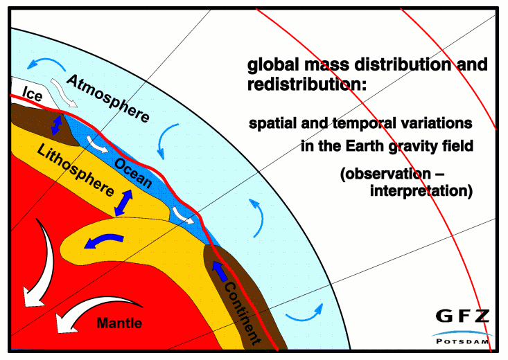
With CHAMP also temporal changes in the gravitational field due to global mass redistributions, which are in general small, slow and large-scaled, can be recovered with a higher signal/noise ratio and an increased spectral resolution. By this, a discrimination between various signal sources becomes possible, provided that the mission duration of CHAMP will last several years. The most interesting temporal gravity variations causing a global signature result from atmospheric mass redistributions, ocean circulation, sea level changes due to polar ice melting or aggregation, and the visco-elastic response of the Earth's lithosphere to past and present loads. To give an example for the gain in information by monitoring temporal gravity changes: gravity always senses the net mass effect of water volume changes opposite to tide gauge or altimetry which measure a combined mass and density (due to temperature changes) effect. A combination of the various monitoring techniques will allow the separation of the global temperature effect in water volume change and the mass exchange between water and ice.
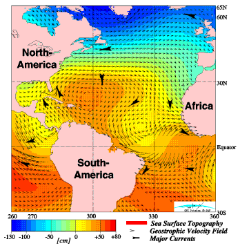
In geophysics, the observed irregularities in the gravity field constrain Earth models obtained from observed seismic velocities. Seismic tomography models of the Earth interior now approach resolutions corresponding to wavelengths of about 2000km. To verify and to discriminate among seismic models, gravity at long-wavelength should be known to a homogeneous accuracy of 1% of its signal which is one order of magnitude more than what presently can be achieved. Such an improvement will strongly enhance studies concerning the structure and static/dynamic mass compensation at the core-mantle boundary and the upper mantle discontinuities, and the conversion of seismic velocities into density values to model lateral density variations in the Earth's interior. This is to address the still unsolved question whether mantle convection takes place in a single, double layered or a mixed system. This will have a large impact on recent models of the driving forces of plate tectonics and on the recycling of oceanic lithosphere to the interior. Besides seismic velocities and gravity, the magnetic field outside the Earth is a direct observable originating from the Earth interior. The evaluation of all three kinds of signals will allow a complete and integrated modelling of the structure and dynamics of the Earth core and mantle generating the gravitational and magnetic long wavelength signals to be observed by CHAMP. The most stringent requirement concerning accuracy and resolution of global Earth gravity field models comes from oceanography. Whereas altimetry monitors the ocean surface with cm-accuracy, the geoid presently is known only to an accuracy of 1m. The geometric difference between ocean surface and geoid, the sea surface topography, is however the essential information to derive directly the absolute mean ocean circulation pattern and the hydrostatic pressure field, respectively. The absolute ocean circulation reflects the currents down to large depths. The knowledge of the absolute ocean circulation with its heat and CO2 transportation is a prerequisite for global climate models and the interpretation of long-term sea level changes. With CHAMP the resolution of the quasi-stationary ocean circulation pattern will be increased from presently 4000km to about 1000km full wavelength.
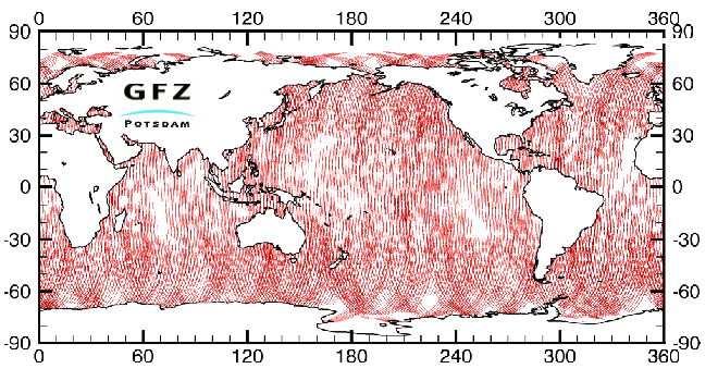
In a very first experiment the feasibility of spaceborne GPS altimetry has been investigated using the nadir-looking GPS antenna aboard CHAMP. Air-borne tests have shown that GPS signals can be received after reflexion over a quiet water surface. With CHAMP and further aircraft tests this principle shall be applied over water in an arbitrary state, ice and snow. Monitoring the surface heights of ocean and polar ice by GPS altimetry gives a valuable tool to collect supplementary data for combination with CHAMP observed temporal gravitational variations. The figure below depicts the coverage with GPS altimetry (reflection points) for a two weeks time period with CHAMP. For the GPS satellites and CHAMP's orbit configuration reflexions up to latitudes of 79°N and S could be evaluated, as simulation studies have shown.
Applications
The geoid constitutes the surface which is most commonly known as 'sea level' in land surveying. Topographic heights are related to the geoid: heights above 'sea level'. Modern satellite positioning systems, like the American GPS, measure point heights which are related to a geometric surface the ellipsoid. In order to transform ellipsoidal heights to topographic heights, the geoid undulations have to be subtracted. To compete with the high GPS measurement accuracy, which is at cm-level, the geoid has to be known with the same accuracy. Then, effective GPS-levelling could replace the man-power intensive geometric levelling in surveying.
With CHAMP, the broad signatures of the geoid will be recoverable with an unpreceded accuracy, i.e. the CHAMP derived global geoid will serve as an ideal basis for a further refinement in regional and local areas evaluating existing or dedicated high resolution gravity information for a detailed geoid computation. The long-wavelength geoid will also give a reference for a unified global height system, being important when employing modern satellite surveying methods and constructing digital terrain models covering large land and ice areas for remote sensing applications and for cartography.
Any progress in the accuracy and completeness of long-wavelength gravity field models will also directly improve the reliability and accuracy of precise satellite orbit restitution as required in satellite altimetry and SAR-interferometry.
For the gravity field, CHAMP commences the international decade of geopotentials. The follow-up missions GRACE (2001) and GOCE (2005) are consequent extensions on the way towards a detailed gravity field modelling for research of the Earth as a system.


