

I-GET/MT
The project I-GET is aimed at developing an innovative strategy of geophysical exploration. This strategy integrates all the available knowledge, from rock physics to seismic and magnetotelluric (MT) data processing and modelling, and exploits the full potential of seismic and electromagnetic exploration methods to detect permeable zones and fluid bearing fractures.
The proposed geothermal exploration approach will be applied in European geothermal systems with different geological and thermodynamic reservoir characteristics: in Italy (high enthalpy reservoir in metamorphic rocks), in Iceland (high enthalpy reservoir in volcanic rocks) and in Germany and Poland (low to middle enthalpy reservoir in sedimentary rocks).
The Groß Schönebeck (Germany) deep sedimentary reservoir is respresentative for large sedimentary basins all over Europe with a borehole currently used as an in situ geothermal laboratory. The main objectives of the geophysical site characterization experiments is to develop high resolution combined electrical conductivity with P- and S-velocity tomographic models for a joint interpretation.
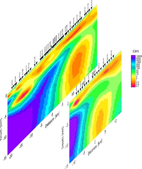
The MT experiment consists of three phases. In the first phase, carried out in summer 2006, MT data was recorded at 55 stations along a 40-km long profile with site spacing between 400 and 800 m (see map below). In order to reduce the effect of the cultural noise, 4 remote reference stations located at distances of about 100 km from the profile were used. This profile is spatially coincident with a seismic tomography profile.
The second phase of the experiment, carried out in winter 2007, consists of a second 20-km long MT profile located about 5 km east of the previous one with 20 stations and a site spacing of 1 km. In order to improve the data quality a station located in the island of Rügen (ca. 300 km away) was used as a remote reference. Together, these profiles provide an electrical conductivity model of the background area.
The third phase of the experiment, also carried out in winter 2007, consists of a dense grid of 158 stations covering the whole area in order to provide a 3D conductivity model (see map below). For this experiment a new data acquisition technique was employed, deploying 5 standard MT sites as base stations (in blue in the figure) and recording only the electric and vertical magnetic fields at the grid stations.