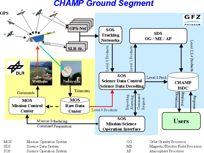
The CHAMP satellite and its on-board instruments continuously produced science data with an overall rate of 10.8kbit/s, and the satellite added 2.2kbit/s of spacecraft house-keeping data, in total 141MByte/d, which could to be downloaded to the 7.3m ground antenna of DLR's receiving station in Neustrelitz (53.5°N, 13°E).
With its telemetry bitrate of 1000kbit/s and a contact time of 28min/d at 450km and 20min/d at 300km S/C altitude during the three to five passes per day, Neustrelitz was capable to receive 210MByte/d (at 450km) and 150MByte/d (at 300km), respectively, of dump data. A second ground station ground station in Weilheim (48°N, 11°E), belonging to DLR's Mission Control Center, was operating as the commanding and satellite control station. It received 'real-time' science and H/K data at a bitrate of 32kbit/s and sent commands at 4kbit/s. Weilheim also served as a back-up station to Neustrelitz, then was being capable to switch to a 1000kbit/s down-link telemetry bitrate.
CHAMP's on-board mass memory unit was organized as a ring buffer and consisted of a science data segment of 100MByte and a H/K data segment of 25Mbyte storage capacity. The on-board data were written and dumped sequentially controlled by a write and dump pointer. The maximum buffer time (maximum time between two overflights over Neustrelitz) was 13 hours. If, by failure, the buffer run full, then the oldest data would have been overwritten.
CHAMP's Raw Data Centre was established at the receiving station Neustrelitz with the following functions: telemetry data reception (Transfer Frames) and long-term storage in the Raw Data Archive, demultiplexing and extraction of science and H/K application packets (level-0 data), immediate transfer of H/K packets to DLR/GSOC, and temporary storage of all level-0 data in the level-0 rolling archive for access by the instrument manufacturers and the processing centre at GFZ Potsdam, where the level-0 long-term archive is located.
Product Generation
The products of levels 1 through 4 were generated at the Science Data System GFZ Potsdam within the
- Orbit and Gravity Field Product Generation System,
- Magnetic and Electric Field Product Generation System and
- Neutral Atmosphere Product Generation System,
and at DLR-DFD Neustrelitz within the
- Ionosphere Product Generation System.
Product archiving, administration and retrieval were organized by the CHAMP Information System and Data Centre (ISDC), located at GFZ Potsdam, which also was the users' www- and ftp-based interface for access to all scientific products of levels 1 through 4.
CHAMP's standard science products were labeled from level-0 to level-4 according to the number of processing steps applied to the original data. Decommutation and Decoding of level-0 data resulted in level-1 products. These were dump-related files, associated with each individual instrument and source aboard CHAMP, and the data content was transformed from the telemetry format and units into an application software readable format and physical units. Level-1 products also include the ground station GPS and laser data. Level-2 products are preprocessed, edited and calibrated experiment data supplemented with necessary spacecraft housekeeping data and arranged in daily files. Level-3 products comprise the operational rapid products and fine processed, edited and definitely calibrated experiment data. Finally, level-4 leads to the geoscientific models derived from the analysis of CHAMP experiment data, supported and value-added by external models and observations.
Within the three fields of research and application persued with CHAMP, the following higher level products were generated:
- Orbit and Gravity Field Products Generation System (GFZ Potsdam)
- level-2: screened accelerometer observations (1 Hz) annotated with calibration parameters, attitude information and thruster firing time events
- level-3: rapid science orbits of CHAMP and the GPS satellites augmented by attitude information and reliability flags and processed within a few hours after data download; CHAMP orbit predictions to serve the laser stations
- level-4: postprocessed precise orbits of CHAMP and the GPS satellites; global Earth gravity field models, represented by the adjusted coefficients of a spherical harmonic expansion of the static and time varying part of the gravitational geopotential: monthly solutions and progressively accumulated solution
- Magnetic and Electric Field Product Generation System (GFZ Potsdam)
- level-2: full rate vector data (10 or 50 Hz) of external magnetic field; calibration matrices derived from the combination of Overhauser and Fluxgate Magnetometer readings; precise attitude from Advanced Stellar Compass both for the spacecraft and the boom; electric field vector, ion density and temperature (all selectable between 1 an 16 Hz); preliminary magnetic activity index determined along the orbit
- level-3: fully calibrated magnetic vectors (5 Hz)
- level-4: main magnetic field models represented as a spherical harmonic expansion to degree and order 14 derived from the combination of spacecraft and ground-based data, updated once per month; lithospheric magnetic field model derived from the coefficients of the spherical expansion for degree and order 15 to 60, separation into a constant and a time varying part by comparison of consecutive models; magnetic activity indices indicating the ring current activity, the polar electrojet activity and the global magnetic activity
- Atmosphere/Ionosphere Product Generation System (GFZ Potsdam/DLR Neustrelitz)
- level-2: list of occultation events (occultation tables);geo-located and time tagged excess path delays through atmosphere annotated with SNR for each occultation event
- level-3: calculated vertical profiles of bending angles; Abel-inverted profiles of refractivity: dry-air temperature, air-density, air-pressure and, adopting temperature from global analyses, water vapour in troposphere and partial water pressure; link-related differential TEC (horizontal/upwards) from differential phases; ionospheric profiles of electron density from GPS occultation measurements


