Snapshots taken by the CHAMP ASC-Startracker (Jan 31, 2002)
The two Advanced Star Compass instruments onboard of CHAMP were used to determine the attitude of the satellite body and the satellite boom. The highly precise determinations were based on pictures, taken by special designed electronic cameras. Each ASC unit operated two of these so called Camera Head Units. The Camera Head Units looked into space while a connected data processing unit compared all luminous objects on the digital pictures with stored star-patterns. This enabled the instrument to determine the attitudes in relation to the identified (fixed) star positions.
Some pictures were routinely inspected by GFZ and DTU in order to check the CHU sensor chips for a possible degradation from e.g. radiation. The picture above is one of these snapshots, taken on the 31st of January 2002. The Field Of View is 18.4° x 13.8°, showing parts of the Lion star constellation. Please notice that the moon is only as small as about 0.5°, appearing much bigger due to ring-shaped reflections from the CHU lens system. Although these bright reflections cover some areas, the CHU was able to detect a couple of stars and sun reflections from a satellite passing through the FOV. You will have to zoom in to pinpoint particular objects.
First humidity profil of the CHAMP GPS Occultation Experiment (Feb 22, 2001)


The profiles of temperature and specific humidity shown in the figures above were observed by CHAMP over the Southern Atlantic (53°S,0.3°W) on February 11, 2001, 19:44 UTC, during the first test of the onboard occultation software of the BlackJack GPS receiver (JPL). Operational meteorological analysis data from the European Centre for Medium-Range Weather Forecasts (ECMWF) and the US National Centers for Environmental Prediction (NCEP), interpolated onto the occultations location, are shown for comparison.
Similar to the first CHAMP profile taken over Antarctica 11 minutes earlier, the CHAMP sounding reached close to the ground and provided high quality data on altitudes above 1 - 1.5 km, i.e. (in this case) above the maritime boundary layer. Also noteworthy was the well resolved temperature structure of the tropopause, similar to the one obtained from the first CHAMP temperature profile.
Note that the temperature profile shown has been calculated under the assumption of a dry atmosphere; it is indeed the deviation from ECMWF meteorological analyses that has been used to calculate humidity. Also note that the raw GPS data has been slightly smoothed in the vertical in order to take account for the limited vertical resolution of the meteorological analyses.
Temperature and humidity profile were calculated by the GFZ radio occultation group at GFZ Potsdam using the CHAMP GPS high rate occultation data, GFZ precise orbit data for CHAMP and GPS satellites, and data from the CHAMP high rate and low latency GPS ground station network operated jointly by GFZ and JPL. ECMWF data was provided by the German Weather Service DWD via the Stratospheric Research Group at the Freie Universität, Berlin. NCEP data was provided by the Climate Prediction Center CPC, Camp Springs.
Star Camera In-Flight Aberration Correction
With the CHAMP star camera software the instrument was able to perform in-flight the astronomical aberration correction. The relativistic effect stems from the movement of the observer (star camera on spacecraft) to the apparent position of a star on the firmament. The velocity of the Earth is ~29.8km/sec, which needs to be considered to correct for the annual aberration, and by knowing the satellite velocity (CHAMP: ~7.6km/sec) from GPS information it was possible to correct for the orbital aberration.
The first two plots depict the inter-boresight angle, IBA, between the two boom-mounted camera heads versus the satellite latitude (declination) on the left and the IBA as time series on the right. The missing aberration correction causes an apparent deflection of the camera heads of up to ±40arcsec. As a consequence the IBA varies elliptically over an orbit.
The plot three and four are same kind of plots, but for a time period where the in-flight aberration correction algorithm was enabled. Now the IBA is constant over an orbit. The flatness of the IBA versus declination demonstrates that there is no deformation of star tracker assembly due to thermal stresses from sun light and eclipses. Figure four shows superpositions of 4 consecutive orbits. The reproducibility is remarkable. Features re-appear at the same position along the orbit. The raw data scatter within a band of only 15arcsec peak-peak. Postprocessing merging the readings of both heads will further reduce the noise to a few arcsec.
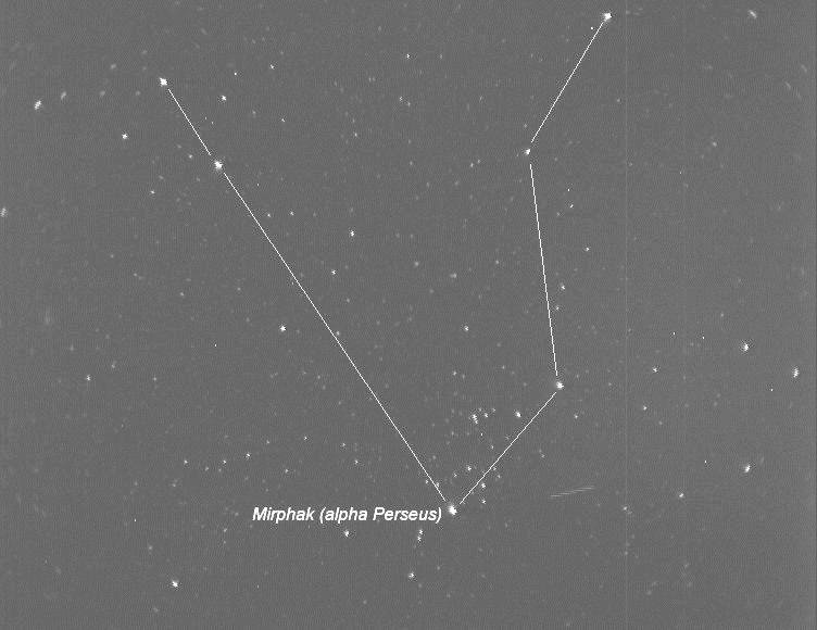
First image of the CHAMP Advanced Stellar Compass
First image of the CHAMP Advanced Stellar Compass (ASC) downloaded to ground. It shows the stars of the Perseus constellation with the bright Mirphak star below the center. On the image you also find another satellite passing by at a very high relative speed - see the faint trace to the right of Mirphak.
The second image shows the result of the analysis as performed by the ASC. Lower left the image is shown with stars correctly identified (green circles) and luminous non-stellar objects (red circles). Protons passing through the camera chip caused the many non-stellar objects. Nominally only a few protons are expected but due to an extreme geomagnetic storm during the CHAMP launch the number is vastly increased.
FGAN Radar Techniques for Space Reconnaissance during CHAMP early Orbit Phase
View/download mpeg-animation (221kB).
- Date of observation: 00y 198d 14h 29m 17s (16.7.2000 14:29:17)
- Time step between images: 40.91s
- Pulse repetition frequency: 110.0Hz
All pictures in courtesy of FGAN FHR/RWA Radar Techniques for Space Reconnaissance.


