


Human and climate controls on Holocene vegetation dynamics, Crete, Greece
Crete has a long history of human land-use with olive grove agriculture starting more than 6500 years ago. In stark contrast to the modern barren landscape of Crete, the island was covered by thick forest in the early Holocene. This projects studies how humans and climate affected the vegetation of Crete during the Holocene. The project is part of a larger study investigating how the change in land-use triggered wide-spread soil erosion, and potentially led to the demise of ancient civilizations such as the Minoans. The project will be performed in collaboration with the Geomorphology section at GFZ. Changes in vegetation will be analyzed by investigating biomarkers in river sediments. The project involves a substantial laboratory work in our clean labs, and analysis of samples on high-precision machines such as Gas-Chromatographs (lab-link). Prior experience, in laboratory work is beneficial but not necessary.
Supervisors: Dr. Richard Ott and Dr. Dirk Sachse.
Drainage Reorganization of SW Germany and its relation to differential uplift and cuesta landscape evolution (suitable as a MSc project)
In areas of mid- to low relief, small perturbations can drive rapid and large scale drainage reorganization (Wickert et al., 2013). The European main water divide that runs through SW German and separates the Rhine from the Danube catchment, has moved significantly since the Miocene induced by large scale drainage reorganization (Ziegler and Dèzes, 2007). Drainage reorganization is driven by differential uplift in SW Germany, and the interactions of river networks with the layered sedimentary stratigraphy of varying erosional resistance. The mountainous regions of the Black forest and Swabian Alb are a result of differential uplift combined with drainage reorganization. However, despite good constraints on total uplift and major river captures, we still lack detailed knowledge of rates and patterns of Neogene uplift and the effects of drainage reorganization on the development of the prominent cuesta landscape of SW Germany. SW Germany exhibits a prominent cuesta landscape, with at least two major escarpments. In the west, this cuesta landscape is bounded by the Black forest mountains. Despite the knowledge of major river reorganization events, it remains unclear if the cuesta landscape is related to drainage reorganization or just a product of tilted stratigraphy. Moreover, the timing of uplift and tiling in the region and especially the Black forest is not constrained well.
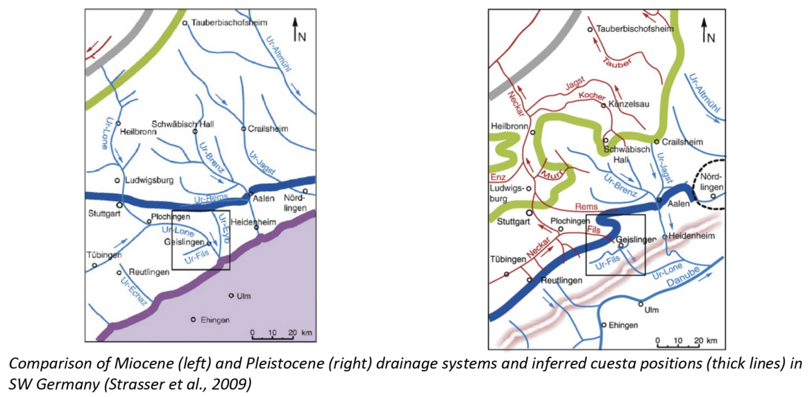
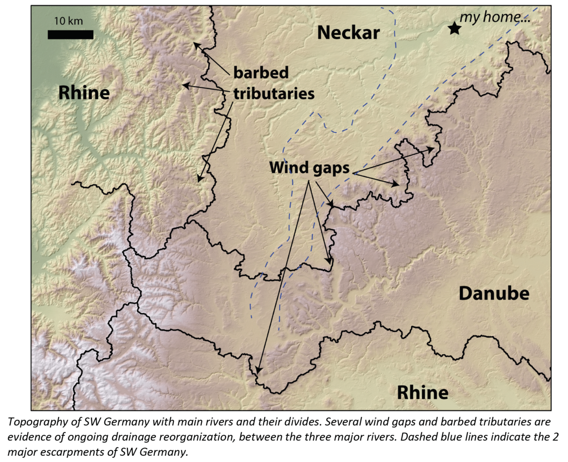
I am searching for a motivated student interested in the development of fluvial topography and its relation to tectonics. You should perform an analysis of the modern Rhine, Danube and Neckar drainage system. You will map signs of river captures in the present landscape (wind gaps, barbed tributaries) and analyze modern river profiles, including mapping of knickpoints and differentiating between lithological and regional kickpoints. These results can be compared to mapping of old river terraces and incision rates, as well as constraints on regional uplift. With observations from this analysis we should be able to make arguments about how and when the cuesta landscape of SW Germany really formed and better determine the timing of uplift in the regions of the Black Forest and Swabian Alb. Tectonically interested students could even model the uplift of the Back forest due fault movement in the Oberrheingraben and the faulting response to erosion after reorganization. For the analysis we can also make use of a database of rock erodbilities, which is currently being developed at GFZ. Skills in Matlab and an interest in surface processes and tectonics are beneficial. The project outcome should be delivered in English, but for literature research good German skills are beneficial.
PI: Dr. Richard Ott.
The development and calibration of a quantitative (and predictive) model for the propagation of a weathering front under a wide range of tectonic and climatic conditions
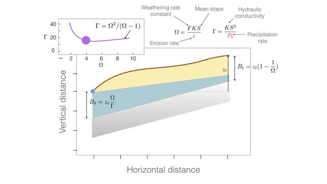
We have recently developed a simple 2D model for the propagation of a weathering front under the assumption that the velocity of the front is in proportion to the velocity of the fluid circulating in the overlying regolith layer. The model couples a surface process model with a hydrological model to predict the velocity of the fluid and the front propagation. The predictions of the model agree (to very first order) with how regolith thickness varies between orogenic and anorogenic systems. It requires, however, further calibration and validation that can only be achieved in three dimensions. The project’s main ambition is the generalisation of the model to three dimensions and its calibration using a database of regolith thickness that is presently being assembled.
PI: Prof. Jean Braun.
The inversion of a large and multi-variate geological dataset to constrain the landscape and tectonic evolution of Taiwan using an existing landscape evolution model in a Bayesian framework
We have developed very efficient methods to solve the basic equations governing surface/bedrock erosion in tectonically active mountain belts and the transport of sediment to the adjacent areas (foreland, margins, etc). Because of their high efficiency, the model can be used inside an optimisation procedure to invert large datasets pertaining to the tectonic and topographic evolution of a mountain belt. This project main objective is to use this method to invert a large, multi-variate database consisting of thermochronological data, past and present sediment flux estimates as well as sediment provenance studies from Taiwan to derive the most plausible tectonic and surface topographic evolution scenario over the past n million years of geological history of the island.
PI: Prof. Jean Braun.
The study of how macroevolutionary processes link to landscape evolution and climate variations using a newly developed population dynamic/evolutionary model
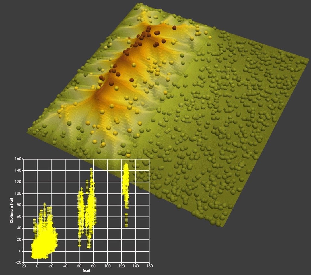
We have developed a simple evolutionary model that is coupled to our landscape evolution model. The model includes factors controlling environmental fitness, spatial competition, mutation and dispersal and predicts population evolution as well as the emergence of genetically specific sub-populations. The model can also be used to compute synthetic phylogenetic trees that can be compared to trees now commonly derived from genetic data. The main objective of this project is to use the model to further investigate the effect of landscape evolution on population dynamics and genetics in either a theoretical manner or to explain how landscape evolution may control species diversity ardor endemism in a given location.
PI: Prof. Jean Braun.
Numerical Modeling of Debris-Flow Initiation Mechanism and Magnitude in the Alpine Environment
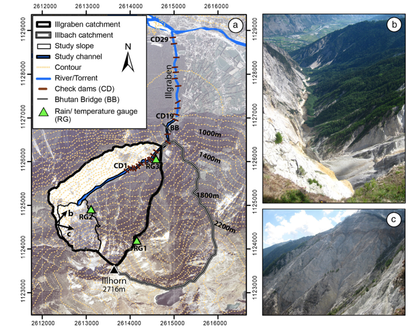
Debris flow is very common in the Alpine environment, which caused destruction of property and loss of lives in these regions. Our understanding of initiation mechanisms and evolution of debris flows is limited due to a lack of direct observations and measurements. We need to combine existing debris flow/landslide database and numerical deterministic simulations to study the initiation mechanism and magnitude. Illgraben in southwest Switzerland, with at least ten years of record at debris basins, is selected for this study because they provide a wealth of geological and geophysical data. There are several possible triggering mechanisms of debris flows in the Illgraben channel system (e.g., failures of landslide dams, hillslope landslides, snowmelt runoff from avalanche deposits or runoff events generated by heavy summer storms). We have developed a 2D model for the initiation and propagation of runoff-generated debris flow in a burned area. The model couples shallow water equations with soil erosion model. In this project, we focus on identifying different initiation mechanisms and developing a numerical model based on this debris flow database. Based on the proposed numerical model, physically based thresholds will be derived to estimate the hydrodynamic conditions coinciding with the timing of debris flow activity in the Alpine environment.
PI: Dr. Hui Tang.
[1] Bennett, G. L., Molnar, P., McArdell, B. W., Schlunegger, F., & Burlando, P. (2012). Patterns and controls of sediment production, transfer and yield in the Illgraben. Geomorphology, 188, 68-82.
[2] Bennett, G. L., Molnar, P., Eisenbeiss, H., & McArdell, B. W. (2012). Erosional power in the Swiss Alps: characterization of slope failure in the Illgraben. Earth Surface Processes and Landforms, 37(15), 1627-1640.
[3] Bennett, G. L., Molnar, P., McArdell, B. W., & Burlando, P. (2014). A probabilistic sediment cascade model of sediment transfer in the Illgraben. Water Resources Research, 50(2), 1225-1244.
Landslide/Debris Flow Frequency Analysis and Hazard Assessment Using Geospatial, Climate Big Data and Machine Learning

Debris flows and Landslides present geomorphological hazards in Alpine regions, threatening life, infrastructure, and property. The magnitude of debris flows become larger due to larger amounts of sediment delivered to the channels and as a result of the predicted increase in heavy precipitation events due to climate change. Landslides are a process with causal links to climate change, primarily through precipitation, but in some cases also through temperature-induced changes of snowfall. We propose to develop a machine learning approach for figuring out the controlling factors and thresholds for debris flows and landslides. We will use this modeling framework to test the hypothesis that natural patterns exist such that geospatial and climate characteristics can be correlated with debris flow/landslide frequency utilizing a machine learning approach. We will use this approach to study and predict debris flow frequency in the western US and the Alps under climate change conditions. By applying our techniques to the database, the study also has the broader impact of leading to improved hazard assessment of debris flows in critical regions of the Western US and the Alps.
PI: Dr. Hui Tang.
[1] Peruccacci, S., Brunetti, M. T., Gariano, S. L., Melillo, M., Rossi, M., & Guzzetti, F. (2017). Rainfall thresholds for possible landslide occurrence in Italy. Geomorphology, 290, 39-57.
[2] Nikolopoulos, E. I., Destro, E., Bhuiyan, M. A. E., Borga, M., & Anagnostou, E. N. (2018). Evaluation of predictive models for post-fire debris flow occurrence in the western United States. Natural Hazards and Earth System Sciences, 18(9), 2331-2343.
Tectonic and climatic control on spatial-temporal evolution of debris-flow fans
Episodic shifts in the position of a debris-flow channel are critical for debris-flow fan evolution and understanding flow hazards because avulsions distribute debris-flow deposits through space and time. However, both the mechanisms of flow avulsion and their effects on the long-term evolution of debris-flow fans are poorly understood. This project will develop a new landscape evolution model to study how debris flow fans evolve through time in response to different types of forcing (tectonics, sediment supply, climate, etc.). The project will analyze new high-resolution topographic data based on remote sensing and satellite image and carry numerical simulations revealing the control factors landscapes in the western United States, Alps, and Argentina Andes. The research will produce a new approach to assessing landslide/debris flow risk based on landscape shape analysis, as well as a way to evaluate the role of climate warming on the evolution of alpine areas.
PI: Dr. Hui Tang.
[1] Staley, D. M., Wasklewicz, T. A., & Blaszczynski, J. S. (2006). Surficial patterns of debris flow deposition on alluvial fans in Death Valley, CA using airborne laser swath mapping data. Geomorphology, 74(1-4), 152-163.
[2] McGuire, L. A., & Pelletier, J. D. (2013). Relationships between debris fan morphology and flow rheology for wet and dry flows on Earth and Mars: A numerical modeling investigation. Geomorphology, 197, 145-155.
The appropriate modelling of carbonate and lacustrine landscapes where the scaling between drained area and fluxes breaks down
Landscape evolution models generally rely on a version of the stream power law whereby water discharge, Qw, and sediment flux, Qs, implicitly scale with drainage area A. This scheme works reasonably well in most of Earth’s landscapes however it fails to capture two common elements: 1) lakes, and 2) highly permeable lithologies. Lakes are common in postglacial and active tectonic landscapes where they act as sediment traps and disrupt the sediment routing system. At the outlet of a lake, the scaling between Qs and A is lost as Qs is essentially reset to zero and the erosivity of the stream is accordingly decreased. In highly permeable lithologies such as limestone, surface runoff does not scale with drained area as a significant fraction, if not all, of the water is rooted subterraneously through karst systems. In these cases, the stream power scaling of water and sediment fluxes with drained area is lost and landscape evolution models based on it will fail to simulate the resulting patterns of erosion. The objective of this project is to modify current routing schemes to account for such situations.
Project under the supervision of Dr. Luca Malatesta.
The implementation of high resolution stratigraphic outputs in landscape evolution models
Commonly, the main output of landscape evolution models (LEMs) is a topography whose morphometrics are then compared against that of natural landscapes. Though, the morphology of a natural landscape only reflects a moment in time — now — and is not the most robust proxy to evaluate a model. LEMs should incorporate outputs reflecting standard geological records such as stratigraphy and thermochronology instead of mainly relying on morphometrics. Stratigraphic outputs can be used to track surface evolution through time against real datasets in a way that morphometrics cannot. The project will seek to implement full resolution stratigraphic models in subdomains of the LEMs after completion of the coupled run (e.g. with a geodynamic model) using constraints (flux, tracers) of the full LEM as boundary conditions for the stratigraphic output.
Project under the supervision of Dr. Luca Malatesta.