


Recent dramatic events (e.g. Tohoku earthquake) have demonstrated that we are only at the beginning in understanding how faults behave. In the next decade, we will need to merge geological, geodetic and seismological information to better constrain future earthquake scenarios which will be shaking mega-cities located to major active faults. That requires more detailed investigation of near-field and directivity effects as well as the assessment of individual earthquake scenarios taking into account fault segmentation and rupture propagation. The overall goal of the project is to address such scientific question for the Main Marmara Sea fault located close to the megacity of Istanbul.
Time frame
- 2017-2020
Funding Helmholtz Recruitment Initiative Cotton
Principal Investigators
- Fabrice Cotton
- Oliver Heidbach
Personnel
Project Website
Cooperations
- Tobias Hergert, TU Darmstadt, Germany;
- Marco Bohnhoff, GFZ Section 4.2, Germany;
We will build a 3D stress evolution model of the larger Marmara Sea and simulate earthquake scenarios (and associated ground-shaking in a second step). With this model key questions about the nature of the earthquake process in the Marmara Sea can be investigated. Is there a creeping segment in the seismic gap south of Istanbul? Can the hypocenter location be determined in a probabilistic way using the simulated stress field? Can we quantify the impact of these findings on the seismic risk for Istanbul? The project is part of a team project (“Urban Fault Observatory”) dedicated to the development of urban, fault and site-specific, probabilistic hazard assessment methods. Milestones of the project will be:
- Refinement of our 3D Marmara model (Hergert and Heidbach, 2011; 2010)
- Validation of the modelling results against geo-data sets (stress and GPS data, seismic events)
- Estimate the model uncertainties and integrate model results in a risk analysis workflow for Istanbul
- Interpretation and publication of the results and presentations at international conferences
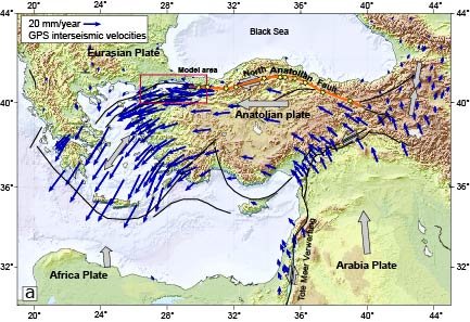
Geodynamic setting: Tectonic setting and GPS-derived velocities in the eastern Mediterranean and of the Marmara Sea south of Istanbul. Blue arrows show the GPS velocities relative to the fixed Eurasia plate from Reilinger et al. (2006). a) Grey arrows indicate the movement of the tectonic plates relative to the Eurasia plate. Orange line denotes the North-Anatolian fault; yellow stars mark the earthquake series of 1939-1999 that ruptured the North-Anatolian fault with 11 subsequent earthquakes from east to west. Black lines denote the plate boundaries; red box indicates the model area.
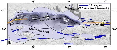
Geodynamic setting :b) Detailed tectonic map of the Marmara Sea region with the complex fault system. Orange lines and stars with years attached denote the parts of the main fault that had an earthquake. The central segment is locked since 1766.
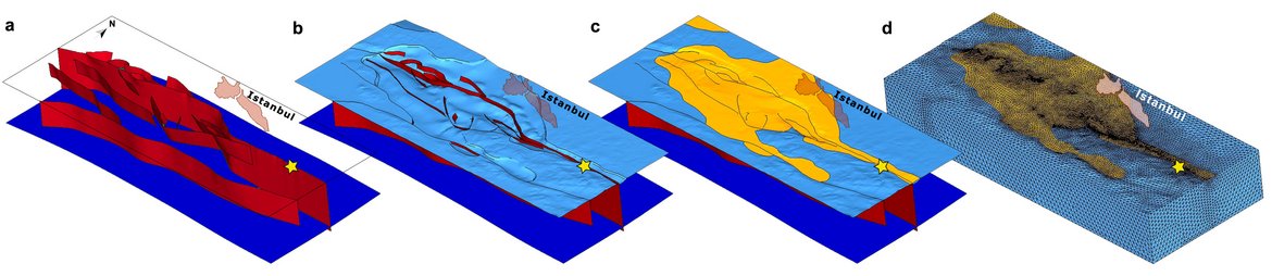
Model geometry: a) Blue surface at 26 ‑35 km depth marks the layer that separates the mantle from the crust. Red surfaces indicate faults that dip between 70° and 90°. b) Light blue layer shows the basement surface at 0-6 km depth. c) Yellow is the sediment infill of 0‑5 km thickness. d) Discretization into finite elements.
Publications/Results
- Hergert, T. and O. Heidbach (2010). Slip-rate variability and distributed deformation in the Marmara Sea fault system, Nature Geoscience, 3, 132-135, http:/doi.org/10.1038/NGEO739
- Hergert, T., Heidbach, O., Becel, A. and M. Laigle (2011). Geomechanical model of the Marmara Sea region - I. 3D contemporary kinematics, Geophys. J. Int. 185, http:/doi.org/10.1111/j.1365-1246X.2011.04991.x
- Hergert, T. and O. Heidbach (2011). Geomechanical model of the Marmara Sea region - II. 3-D contemporary background stress field, Geophys. J. Int., http:/doi.org/10.1111/j.1365-1246X.2011.04992.x
- Reilinger, R., McClusky, S., Vernant, P., Lawrence, S., Ergintav, S., Cakmak, R., Ozener, H., Kadirov, F., Guliev, I., Stepanyan, R., Nadariya, M., Hahubia, G., Mahmoud, S., Sakr, K., ArRajehi, A., Paradissis, D., Al-Aydrus, A., Prilepin, M., Guseva, T., Evren, E., Dmitrosta, A., Filikov, S.V., Gomez, F., Al-Ghazzi, R. and G. Karam (2006). GPS constraints on continental deformation in the Africa-Arabia-Eurasia continental collision zone and implications for the dynamics of plate interaction. J. Geophys. Res. 111, doi.org/10.1029/2005JB004051

