

Automated Lithological Differentiation in the Makhtesh Ramon, Israel, based on Hyperspectral DAIS Image Data

Testsite
This figure shows a part of a DAIS image covering the Makhtesh Ramon (Negev) in Israel with details of the Mount Shen Ramon. The Makhtesh Ramon is a deeply eroded anticlinal structure characterized by a high variety of Mesozoic formations. The test area shows several mining localities for gypsum, kaolinite and bauxite, and is marked by a syenitic stock separated in several, different hydrothermally altered zones. Image data of this area were acquired during the DAIS-LSF-Campaign in August 1997. The testsite extension is 800 x 512 pixels with a pixelsize of about 4 m.
Due to the high spectral resolution of hyperspectral remote sensing instruments it is possible to identify rocks and minerals, such as clays, carbonates and sulfates, which show diagnostic spectral characteristics. The most important diagnostic feature are absorption bands.
Method:
For an automatic detection of minerals, features must be extracted in a first step, that describe the position and shape of the absorption bands. For this purpose the convex-hull-function is suitable. The absorption depth is calculated for each band according to the following equation:
Depth = 1.0 - Spectrum / Convex-hull-function.
Due to a strong noise content especially in the SWIR bands an artificial neural network was used for classification. The used Multilayer Perceptron (MLP) represents a non-linear regression model whose parameters were estimated by training samples.
Result:
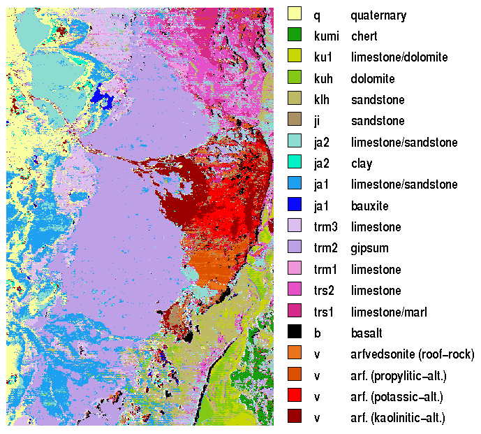
The classification result shows a good agreement with the stratigraphie of the g eological map, which results from the circumstance that the same material was de posited for wide areas within certain periods mostly . The example of the Shen Ramon (see at right center of figure) demonstrates the potential of hyperspectr al data for the separation of different alteration zones in a former homogeneous intrusiv rock (Syenit/Arfvedsonite). As a function of pressure and temperature different zones with appropriate new minerals developed. The separation of this zone results from the spectral characteristic in the SWIR range of the regenerat ed minerals such as Kaolinite, Chloride and Epidot and in the strong influence o f two and trivalent ferruginous oxide content in VNIR.
A direct identification of minerals is not possible with exception of the kaolinitical zone due to the too small SNR and the very small albedo at the same time. The different sandstone layers (klh, ji, ja2) show diagnostic bands only in the TIR and were classified by different ferruginous oxide contents in the VNIR. Limestones and Dolomite differentiate themselves primary by different diagnostic bands in the SWIR with 2300-2350nm. The differences of temporally independently deposited sediments of Triassic (trm, trs), Jurassic (ja1, ja2) and Cretaceous (ku1, cow) result from varying ferruginous oxide content. Gypsum is the dominating mineral of the Image. It shows diagnostic bands in the SWIR, which are preserved in a absorbed form even by transforming Gypsum into Anhydrite and Bassanit at the surface. Clays occur in alternation with Hornstein (kumi), as chocolate clay (ja2) in the bauxite (ja1) and in one of the alteration zones. The clays consist mainly of Kaolinite and can be identify by a double absorption feature at 2160nm and 2200 nm. Loose material (alluvium) is mapped as independent unit in contrast to main rock. However, debris fans show partly the same spectral signature as the origin rock, thus is shown by a fan with jurassic limestone/sandstone in the gypsum complex at the left figure side and by the debris fan at the western slope of Shen Ramon. The latters are identified correctly by the MLP.