SAND (Proposal)
A hyperspectral sensor for the analysis of dryland degradation
SAND (Spectral ANalysis of Dryland Degradation for global Desertification Assessment) proposes a space-borne imaging spectrometer (hyperspectral) mission measuring bio-geochemical/bio-geophysical variables to determine land degradation processes in semi-arid geographical areas.
Arid and semi-arid lands cover approximately one third of the continental surface of the Earth. They include the deserts and their semi-arid and sub-humid dry margins, and the subtropical Mediterranean latitudes. The semi-arid ecosystems provide important land resources for adapted agricultural production and grazing systems. The importance of thoroughly monitoring the state of the environment in areas considered at risk, in the context of global climatic change and worldwide desertification dynamics, has long been recognised. These facts have led to the ratification of the UN Convention to Combat Desertification (UNCCD) by almost 200 nations worldwide. This agreement emphasises the need to assess land degradation and desertification processes.
The status of dryland systems is controlled to a large extent by a fragile equilibrium between soil, vegetation and water resources. Precipitation rates are generally low and rainfall events are known to be irregular and of high intensity. Natural ecosystems and traditional land use practices have largely adapted to these conditions over time, and thus, assure an optimum use of available resources. Dryland degradation may be triggered by (global) climatic change and/or human mismanagement. While the former may result in longer and more frequent drought events, the latter one mainly consists of inappropriate land use practices. Both may induce changes in surface properties, impacting the type and density of the vegetation cover.
Many of these changes can be detected remotely by measuring the spectral characteristics of the land surfaces. Accordingly, a high-spectral resolution remote sensing system such as the proposed SAND substantially increase these detection capabilities.
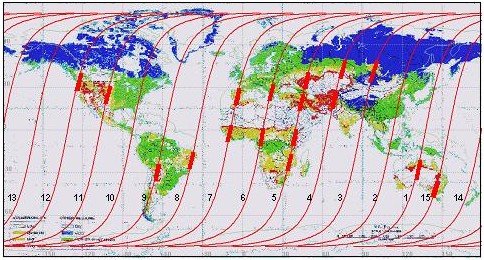
The SAND mission presents a sensor concept providing global coverage (Fig. 1).
SAND's global coverage is at a reasonable spatial and very high spectral resolution, allowing a quantitative derivation of land surface variables. This includes vegetation parameters and soil-related information such as foliage chemistry, water content, fractional cover, chemical composition, organic matter content and information about the lithological background for selected targets.
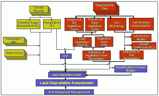
The quantitative parameters determined with the hyperspectral data are to be incorporated into erosion and dryland degradation models to (a) monitor land degradation processes, (b) assess land degradation status (LDS) via the use of a globally applicable LDS index, and (c) gain indicators for characterising specific surface properties related to water cycles, erosion processes and plant productivity in drylands.
The SAND proposal was submitted in January 2002 to ESA by the GeoForschungsZentrum Potsdam, in response to the 2d Call for Earth Explorer Opportunity Missions, part of The Living Planet Programme. The Lead Investigator is Dr. Hermann Kaufmann (GFZ Potsdam, Germany), supported by Dr. Joachim Hill (University of Trier, Germany), Andreas Mueller (DLR, Germany), and Dr. Karl Staenz (Canada Center for Remote Sensing, Canada). Numerous scientists from Spain, Israel, France, Germany, Australia, USA, Italy, Sweden, The Netherlands, Denmark, and Switzerland are associated in this project. The SAND mission is supported by Astrium GmbH and Galileo Avionica.
SAND was among the 9 proposals recommended for selection by the Earth Science Advisory Committee. Six of them were funded, among which SAND was not.


