

MApping SOil variability within rainfed MEDiterranean agroecosystems using hyperspectral data - MASOMED
Funding by: EU-FP7 EUFAR (EUropean Facility for Airborne Research) program through the MASOMED Transnational Access grant, with additional support from the EnMAP Science Program (50EE1923) funded by the German Federal Ministry of Economics and Technology under the DLR Project Management Agency
Funding ID: Grant agreement No 312609 (EUFAR)
Funding period 2017-2020
Project partners: Centro de Investigaciones Energéticas, Medioambientes y Tecnológicas (CIEMAT) I Department of Desertification and Geoecology (3EEZA) I Technical University of Denmark (DTU) I Tel Aviv University (TAU) I Área de Sistemas de Teledetección (INTA)
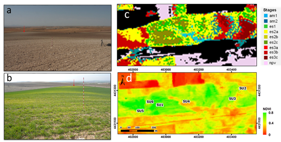
Cultivation and land use practices have a long history within the Mediterranean region exploiting soils as a natural resource. The soils are an essential factor contributing to agricultural production of rain-fed crops such as cereals, olive groves and vineyards. Inadequate management is endangering soil quality and productivity, and in turn crop quality and productivity are affected. The main objective of this project is to map soil and crop variability related to crop stress and land management within a Mediterranean environment based on hyperspectral data within the visible, near-infrared, short-wave infrared as well as thermal infrared (0.4-12 µm). For this purpose, airborne hyperspectral imagery are acquired during the growing season within an agricultural area in central Spain. Simultaneous to the airborne campaign, in-situ data are collected for the characterization of soil and crop variability including chemical and biophysical variables, soil degradation stages, and crop production in selected test sites. In the frame of MASOMED the following issues will be pursued:
- Assessing the spatial distribution of the different rainfed agroecosystems according to abiotic and biotic properties;
- Relating vegetation stress to soil degradation processes and conditions;
- Detecting changes related to soil erosion by comparing current conditions with those identified in Schmid et al. (2016); and
- Testing the transferability of the methods used to future hyperspectral space-borne sensors such as EnMAP, PRISMA, SHALOM, CHIME and SBG.
Publications
Chabrillat, S., Schmidt, T., Milewski, R., Escribano, P., Garcia, M., Ben-Dor, E., Guillaso, S., Pelayo, M., Reyes, A., Sobejano-Paz, V. and Michavila, M. (2018): Mapping Crop Variability Related to Soil Quality and Crop Stress Within Rainfed Mediterranean Agroecosystems Using Hyperspectral Data. DOIProceedings of 9th Workshop on Hyperspectral Image and Signal Processing: Evolution in Remote Sensing (WHISPERS).
Conference presentations (talks and posters)
Milewski, R., Schmidt, T., Escribano, P., Ben-Dor, E., Michavila, M., and Chabrillat, S. (2020): Mapping of Crop Stress Related to Soil Degradation within Rainfed Mediterranean Agricultural Areas using Hyperspectral Optical and Thermal Data. EGU General Assembly, 3-8 May 2020, Vienna.
Milewski, R., Chabrillat, S., Schmidt, T., Escribano, P., Garcia, M., Ben-Dor, E., Guillaso, S., Pelayo, M., Reyes, A. and Michavila, M. (2019): Use of Bi-Temporal Hyperspectral Imagery to Determine the Influence of Soil Degradation on Rainfed Crop Yield. 11th EARSeL SIG Imaging Spectroscopy Workshop 2019, 6-8 February 2019, Brno, Czech Republic.
De Miguel, E., Carrascosa, V. B., Lagos, N. G., Michavila, M., Schmidt, T. and De la Cámara, Ó. G. (2018): Quality of INTA-AHS Images for Estimating Apparent Thermal Inertia in Soils. 38th International Geoscience and Remote Sensing Symposium (IGARSS), 22-27 July 2018, Valencia, Spain.

