

The research of the GFZ Remote Sensing Section within the TERENO network is aimed to monitor evapotranspiration of agricultural areas linking ground based data of climate and soil moisture gauging stations with remote sensing data. Thereby the long‐term and extensively monitoring is focused. Furthermore the influence of external variables affecting the evapotranspiration is analysed. Actual the research in this field is focused on the retrieval of soil moisture using multisensoral remote sensing data and the multitemporal analysis of permanent soil pattern with respect to specific soil parameters.
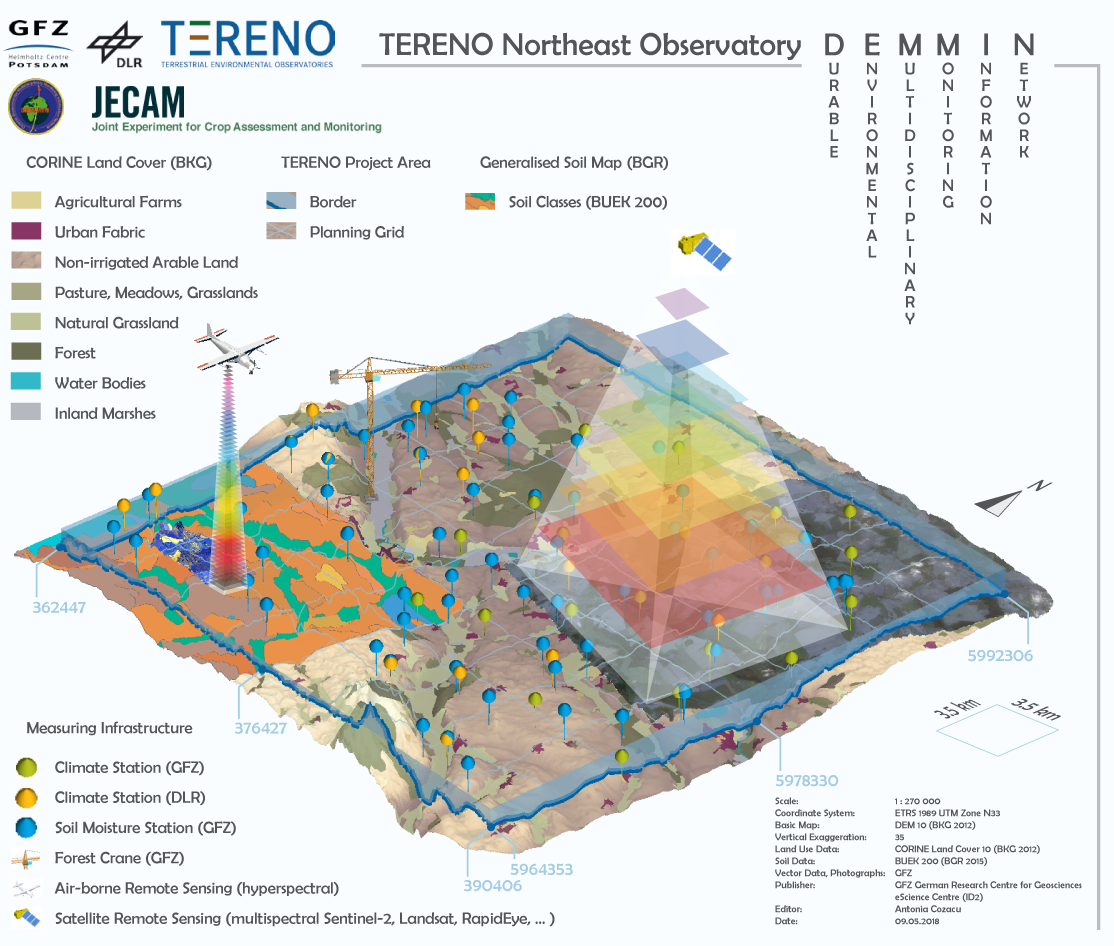
As test site the Durable Environmental Multidisciplinary Monitoring Information Network –DEMMIN® (53°52’ N; 13°13’E) installed by DLR Neustrelitz in 2000 and belonging to the German observatory network TERENO since 2011 was selected for that analysis. The test site will provide long‐term statistical series of system variables for the analysis and prognosis of Global Change consequences within the 15 years observation term of TERENO. The DEMMIN® test field is considered as a rather heterogeneous and intense agricultural area with highly diverse soil properties from soils developed on glacial substrates. Single crops cover large surfaces. Bare soils only exposed over entire fields before sowing and after harvesting of rotating crops such as wheat, rape and corn.

The existing climate network of 25 gauging stations was extended by GFZ with 20 additional climate gauging stations, 63 soil moisture gauging station under fields and a forest crane. The 45m high crane allows evaluating the potential of different remote sensing sensors and techniques. Due to GPS based crane control system multitemporal analysis of defined forest areas can be performed. The crane, when outfitted with hyperspectral sensors, can be used for example to investigate the reflection of the tree crowns with biophysical processes and explore, for example, how the biomass or photosynthesis of the vegetation is connected. The collected data can then be used to analyze satellite data and also for the preparation for the future remote sensing missions like the German hyperspectral EnMap or the ESA Sentinel‐2 mission.
The TERENO site Demmin is one of the JECAM (Joint Experiment for Crop Assessment and Monitoring) monitoring sites.
Data & publications
Itzerott, Sibylle; Hohmann, Christian; Stender, Vivien; Maass, Holger; Borg, Erik; Renke, Frank; Jahncke, Dirk; Berg, Matthias; Conrad, Christopher; Spengler, Daniel (2018): TERENO (Northeast), Climate stations of the GFZ German Research Centre for Geoscienes (GFZ). V. 2.0. GFZ Data Services GFZ Klimastationen
Itzerott, Sibylle; Hohmann, Christian; Stender, Vivien; Maass, Holger; Borg, Erik; Renke, Frank; Jahncke, Dirk; Berg, Matthias; Conrad, Christopher; Spengler, Daniel (2018): TERENO (Northeast), Soil moisture stations of the GFZ German Research Centre for Geoscienes (GFZ). V. 1.0. GFZ Data Services. GFZ Bodenfeuchtestationen
Borg, Erik; Maass, Holger; Renke, Frank; Jahncke, Dirk; Stender, Vivien; Hohmann, Christian; Berg, Matthias; Itzerott, Sibylle; Spengler, Daniel; Conrad, Christopher (2018): TERENO (Northeast), Climate stations of the German Aerospace Center (DLR). V. 1.0. GFZ Data Services. DLR Klimastationen
Heinrich, I., Balanzategui, D., Bens, O., Blume, T., Brauer, A., Dietze, E., Gottschalk, P., Güntner, A., Harfenmeister, K., Helle, G., Hohmann, C., Itzerott, S., Kaiser, K., Liebner, S., Merz, B., Pinkerneil, S., Plessen, B., Sachs, T., Schwab, M. J., Spengler, D., Vallentin, C., Wille, C. 2019 - Regionale Auswirkungen des Globalen Wandels: Der Extremsommer 2018 in Nordostdeutschland -DOI
Heinrich, I., Balanzategui, D., Bens, O., Blasch, G., Blume, T., Böttcher, F., Borg, E., Brademann, B., Brauer, A., Conrad, C., Dietze, E., Dräger, N., Fiener, P., Gerke, H. H., Güntner, A., Heine, I., Helle, G., Herbrich, M., Harfenmeister, K., Heußner, K.-U., Hohmann, C., Itzerott, S., Jurasinski, G., Kaiser, K., Kapple, C., Koebsch, F., Liebner, S., Lischeid, G., Merz, B., Missling, K. D., Morgner, M., Pinkerneil, S., Plessen, B., Raab, T., Ruhtz, T., Sachs, T., Sommer, M., Spengler, D., Stender, V., Stüve, P., Wilken, F. 2018 - Interdisciplinary Geo‐ecological Research across Time Scales in the Northeast German Lowland Observatory (TERENO‐NE) - DOI
Harfenmeister [Heupel], K., Spengler, D., Itzerott, S. 2018 - A Progressive Crop-Type Classification Using Multitemporal Remote Sensing Data and Phenological Information - DOI
Blasch, G., Spengler, D., Hohmann, C., Neumann, C., Itzerott, S., Kaufmann, H. 2015 - Multitemporal soil pattern analysis with multispectral remote sensing data at the field-scale - DOI
Blasch, G., Spengler, D., Itzerott, S., Wessolek, G. 2015 - Organic Matter Modeling at the Landscape Scale Based on Multitemporal Soil Pattern Analysis Using RapidEye Data - DOI