

FERN.Lab

As a technology platform, FERN.Lab combines scientific expertise in the field of remote sensing with social, ecological and economic needs of our time. We support users in the development of methods for the analysis of remote sensing data. FERN.Lab offers services in consulting, technology development and customized information products based on remote sensing data
contact: Dr. Daniel Spengler, Dr. Julia Neelmeijer
HYPERedu – EnMAP education initiative

In view of the rising number of imaging spectrometers deployed on airborne platforms as well as the recently launched and upcoming space-borne imaging spectroscopy missions, an increasing demand for Earth observation education and training activities with a focus on hyperspectral imagery is expected in the next few years.
Therefore, the development of HYPERedu, an online learning platform for hyperspectral remote sensing hosted on EO College has started as part of the education initiative within the EnMAP mission preparation. In September 2019, HYPERedu started to provide annotated slide collections as well as hands-on tutorials using the open-source EnMAP-Box , covering basic principles, methods as well as applications of imaging spectroscopy. The content is continuously extended and will be complemented by further educational materials such as films. In addition, a first Massive Open Online Course (MOOC) with several modules and a certificate is planned to be opened in 2021.
contact: Dr. Saskia Förster Dr. Arlena Brosinsky Dr. Theres Küster
Radiance Light Trends
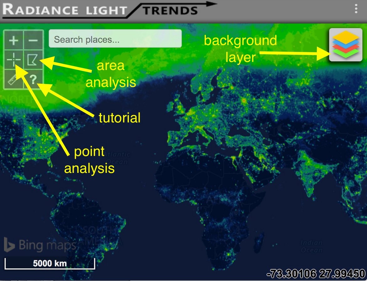
Radiance Light Trends web application was developed in order to make it possible for anyone to quickly analyze trends in Earth’s night light emissions. While the data underlying the app were already freely available, downloading and processing the large datasets takes considerable time and expertise. Even for an expert who had already downloaded the data, producing a trend for a selected area used to take between 30 minutes to around one day, depending on the complexity of the area under analysis. With the new webapp, developed as part of the GEOEssential project, this task can now be completed in about 15-30 seconds. In addition to democratizing the data, this tool provides considerable benefit to experts, because of the greatly increased speed.
In addition to providing the raw data, the application produces attractive charts, and optionally performs linear or exponential fitting to the data. The intent is that this will be a useful tool for city managers aiming to better understand trends in light emissions from their areas of responsibility, as well as for activists aiming to raise awareness of unsustainable increases in light (or, more hopefully, to eventually demonstrate progress towards reduction of light pollution). This report briefly outlines the functionality of the web application.
contact: Dr. Christopher Kyba& Helga Kuechly