back
Estimating building inventory for rapid seismic vulnerability assessment: Towards an integrated approach based on mulit-source imaging.
Wieland, M., Pittore, M., Parolai, S., Zschau, J., Moldobekov, B., Begaliev, U.
Rapidly growing spatial concentrations of people, infrastructure and financial values in earthquake prone areas over the last decades have lead to drastically increased seismic risk. In particular, in developing countries, such as many Central Asian countries, rapid urban growth is often accompanied by unplanned and highly vulnerable settlements, which dynamically change over short time-scales (a few years). The increasingly short time-scales, in combination with the large spatial extent and fragmentation over which modification to vulnerability scenarios occur, represent a great challenge for local governments, which are often unable to continuously update an exposed building stock in order to adjust disaster risk reduction efforts accordingly. An efficient vulnerability model should be able to cope with the increasing spatio-temporal variability of the dynamics of urban areas in order to successfully contribute to the main seismic risk model.
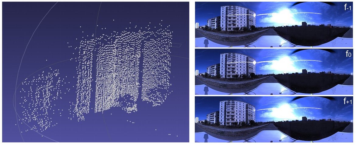
In this paper we propose a novel multi-source method for evaluating structural vulnerability-related building features in a time- and cost-efficient manner based on satellite remote sensing and ground-based omnidirectional imaging. Latest image processing algorithms and computer vision techniques are used on multiple imaging sources within the framework of an integrated sampling scheme, where each imaging source and technique is used to infer specific, scale-dependent information.
An application of the method to Bishkek, the capital of Kyrgyzstan, showed that an initial analysis of medium-resolution satellite images from Landsat sensors can provide a rapid standardized and transferable way to suitably partition a previously unknown city into homogeneous urban structure types. It therefore allowed for a systematic stratified sampling to identify representative sample areas for a local assessment at building scale. Ground-based omnidirectional image-capturing proved to be fast and easy to deploy in the field. As a preliminary result for a small subset of buildings we showed, that based on a fully automatic processing of the captured omnidirectional images, it is possible to extract georeferenced information about geometrical and structural features of buildings. In combination with the outputs of suitable analyses of satellite images, these methodologies allowed to compile a multi-parameter database of inventory features. The automatically extracted features coming from multiple imaging sources in combination with information coming from the World Housing Encyclopedia (WHE) allowed for a first vulnerability classification of the observed buildings according to EMS-98.