

Extreme curvature of shallow magma pathways controlled by competing stresses: insights from the 2018 Sierra Negra eruption.
Davis, T., Bagnardi, M., Lundgren, P., Rivalta, E. (2021)
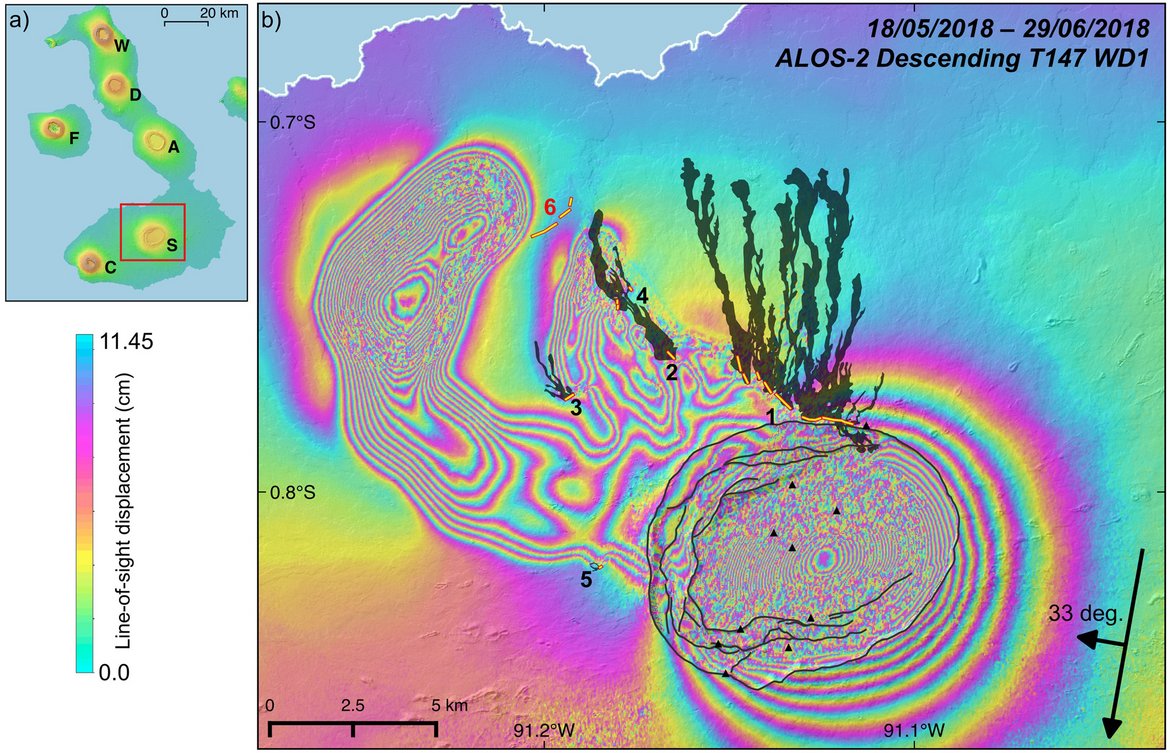
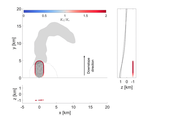
Eruptions at shield volcanoes often occur from radially aligned linear fissures fed by blade-like magma-filled cracks (dykes). The fissures of the 2018 Sierra Negra eruption were scattered on the flank of the volcano. Space-borne radar interferometric data (interferometric synthetic aperture radar) revealed that, unexpectedly, part of the eruption was fed by a 15 km long, tortuous and flat-lying dyke (sill). Here we develop a framework that captures the full three-dimensional (3D) kinematics of non-planar intrusions. This includes both an analytical and comprehensive numerical scheme. We constrain the models such that they match the observed ground deformation at Sierra Negra. We show that the peculiar sill trajectory is due to the inherently unstable nature of sills at shallow depth and the progressive flattening of the volcano flank. Indeed, a steep slope is what commonly drives and stabilises the geometry of magma propagating away from the volcano summit. By developing a method that accounts for the interaction of all these factors, these 3D models open the possibility to understand and simulate the geometry of magma transport at any volcanic system.
| Geophysical Research Letters, 48, 13 | DOI: https://doi.org/10.1029/2021GL093038 |
A self-similar dynamic rupture model based on the simplified wave-rupture analogy.
Dahm, T., Heimann, S., Metz, M., Isken, M. P. (2021)
Finite rupture earthquake simulation soften involve a large number of model parameter and their Inversion from sparse seismic data is non-unique. Estimating the parameter uncertainties is an additional challenge because of the large computational effort. Here, we suggest a simplified self-similar fracture model with only a few parameters, where the propagation of the fracture front is decoupled from the calculation of the slip. The physics-based, approximative method is flexible and computationally efficient. Strengths and limitations of the new method are demonstrated with real-case examples of well-studied events, including the Mw 8.3 2015 Illapel, Chile, megathrust earthquake and examples of normal and supershear continental intraplate earthquakes. Despite its simplicity the model can simulate a broad range of observations ranging from different rupture-front isochrones and slip distributions to directional waveform effects or high slip patches. The temporal evolution of slip rate and rise time are implicitly estimated from the incremental growth of the rupture and the stress drop without imposing any additional constraints. The new model is implemented in the open-source python toolbox for seismology (Pyrocko).
| Geophysical Journal International, 225, 3, 1586-1604 | DOI: https://doi.org/10.1093/gji/ggab045 |
Seismicity at the Castor gas reservoir driven by pore pressure diffusion and asperities loading.
Cesca, S., Stich, D., Grigoli, F., Vuan, A., López-Comino, J. Á., Niemz, P., Blanch, E., Dahm, T., Ellsworth, W. (2021)
The 2013 seismic sequence at the Castor injection platform, offshore Spain, reached magnitude Mw 4.1. It is one of the most important cases of induced seismicity in Europe and a rare example of seismicity induced by gas injection to fill an Underground Gas Storage. We resolved the earthquakes geometry and the rupture propagation by applying advanced seismological techniques to an enhanced waveform dataset. The sequence occurred by progressive fault failure and unlocking, with seismicity initially migrating away from the injection points, triggered by pore pressure diffusion, and then back again, breaking larger asperities loaded to higher stress and producing the largest earthquakes. Seismicity occurred almost exclusively on a secondary fault, located below the reservoir, dipping opposite from the reservoir bounding fault.
| Nature Communications, 12, 4783 | DOI: https://doi.org/10.1038/s41467-021-24949-1 |
Reservoir-Triggered Earthquakes Around the Atatürk Dam (Southeastern Turkey).
Büyükakpinar, P., Cesca, S., Hainzl, S., Jamalreyhani, M., Heimann, S., Dahm, T. (2021)
After the impoundment of the Atatürk Dam, the largest dam in Turkey, the local seismicity rate substantially increased in the 1990er, as previously observed for other reservoirs worldwide. In 2017 and 2018, two damaging earthquakes with magnitudes 5.5 and 5.1 occurred in the town of Samsat near the Atatürk Reservoir. We analyzed the spatiotemporal evolution of seismicity and its source properties in relation to the temporal water-level variations and the stresses resulting from surface loading and pore-pressure diffusion. We find that the water level and seismicity rates are anti-correlated, which is explained by the stabilization effect of the gravitational-induced stress imposed by water loading on the local faults. On the other hand, the overall effective stress in the seismogenic zone increased over decades due to pore-pressure diffusion, explaining the enhanced activity during recent years. The reservoir-induced stress changes finally focused on the region where the two damaging earthquakes occurred in 2017 and 2018.
| Frontiers in Earth Science, 9, 663385 | DOI: https://doi.org/10.3389/feart.2021.663385 |
Stress inversion in a gelatin box: testing eruptive vent location forecasts with analog models.
Mantiloni, L., Davis, T., Gaete Rojas, A. B., Rivalta, E. (2021)
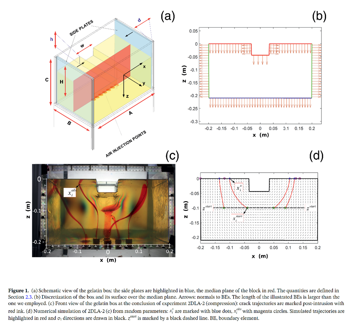
Assessing volcanic hazard in regions of distributed volcanism is challenging because of the uncertain location of future vents. A statistical-mechanical strategy to forecast such locations was recently proposed: here we test it on analog models. We stress a gelatin block laterally and with surface excavations, and observe the surface arrivals of air-filled cracks. Then, we sample the distributions of parameters describing the stress state of the gelatin block with a Monte Carlo approach, matching deterministic simulations of surface arrivals with observed ones. While the individual stress parameters remain unconstrained, we effectively retrieve their ratio and successfully forecast the arrival points of subsequent cracks.
| Geophysical Research Letters, 48, 6 | DOI: https://doi.org/10.1029/2020GL090407 |
Seismological and geophysical signatures of the deep crustal magma systems of the Cenozoic volcanic fields beneath the Eifel, Germany.
Dahm, T., Stiller, M., Mechie, J., Heimann, S., Hensch, M., Woith, H., Schmidt, B., Gabriel, G., Weber, M. (2020)
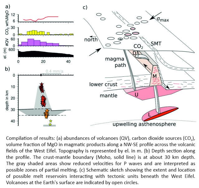
The Quaternary volcanic fields of the Eifel (Rhineland-Palatinate, Germany) had their last eruptions less than 13,000 years ago. Recently, deep low-frequency (DLF) earthquakes were detected beneath one of the volcanic fields showing evidence of ongoing magmatic activity in the lower crust and upper mantle. In this work, seismic wide- and steep-angle experiments from 1978/1979 and 1987/1988 are compiled, partially reprocessed and interpreted, together with other data to better determine the location, size, shape, and state of magmatic reservoirs in the Eifel region near the crust-mantle boundary. We discuss seismic evidence for a low-velocity gradient layer from 30–36 km depth, which has developed over a large region under all Quaternary volcanic fields of the Rhenish Massif and can be explained by the presence of partial melts. We show that the DLF earthquakes connect the postulated upper mantle reservoir with the upper crust at a depth of about 8 km, directly below one of the youngest phonolitic volcanic centers in the Eifel, where CO2 originating from the mantle is massively outgassing. A bright spot in the West Eifel between 6 and 10 km depth represents a Tertiary magma reservoir and is seen as a model for a differentiated reservoir beneath the young phonolitic center today. We find that the distribution of volcanic fields is controlled by the Variscan lithospheric structures and terrane boundaries as a whole, which is reflected by an offset of the Moho depth, a wedge-shaped transparent zone in the lower crust and the system of thrusts over about 120 km length.
| Geochemistry Geophysics Geosystems (G3), 21, 9 | DOI: https://doi.org/10.1029/2020GC009062 |
The rebirth and evolution of Bezymianny volcano, Kamchatka after the 1956 sector collapse.
Shevchenko, A. V., Dvigalo, V. N., Walter, T. R., Mania, R., Maccaferri, F., Svirid, I. Y., Belousov, A. B., Belousova, M. G. (2020)
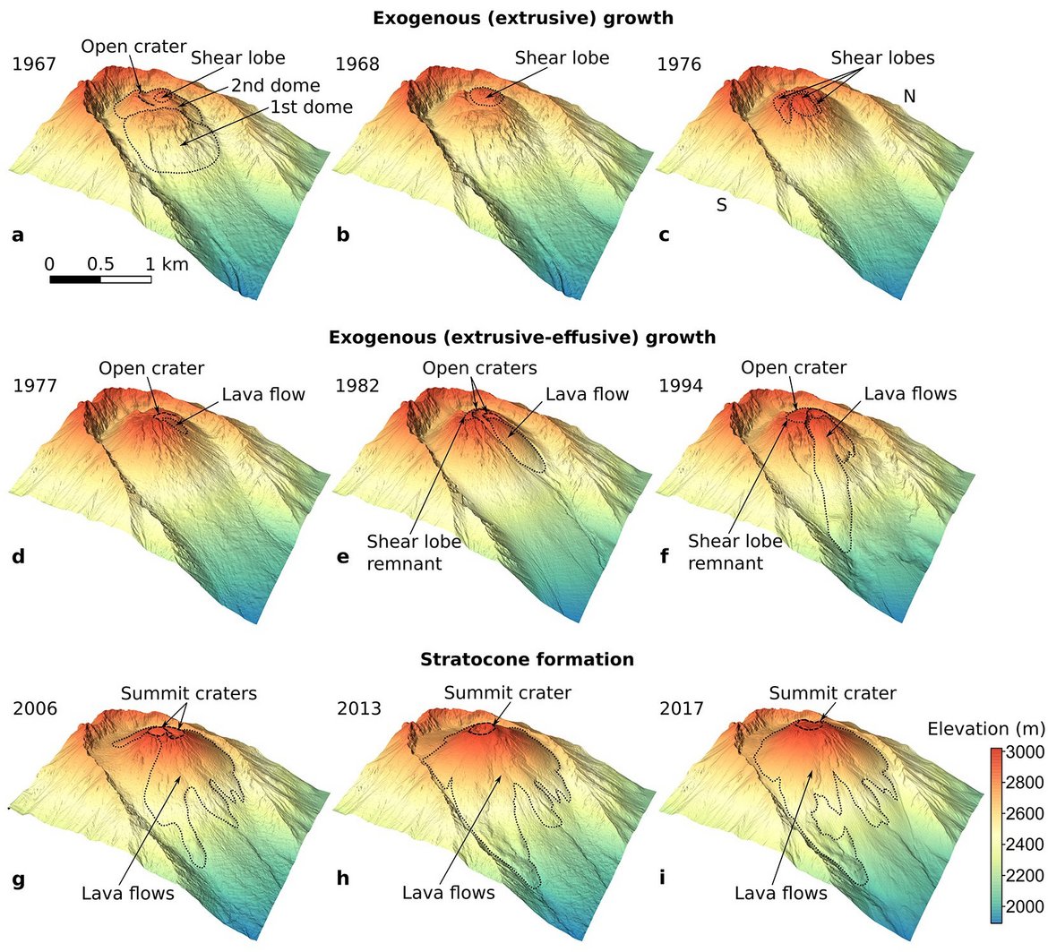
We used 7-decade-long photogrammetric data acquired over Bezymianny volcano, Kamchatka, to document a rebirth of a new volcanic edifice after the 1956 sector collapse. Thus we revealed all morphological changes, identified three main stages of the new edifice development, and detected a gradual vent centralization that can be related to loading changes, affecting magma pathways at depth. The calculated long-term growth rate allowed us to estimate the regain of the pre-collapse size of the volcano within the next 15 years. This work, for the first time, sheds light on the complex regrowth processes following sector collapses of volcanic edifices.
| Communications Earth & Environment, 1, 15 | DOI: https://doi.org/10.1038/s43247-020-00014-5 |
Probabilistic Moment Tensor Inversion for Hydrocarbon-Induced Seismicity in the Groningen Gas Field, The Netherlands, Part 1: Testing.
Kühn, D., Heimann, S., Isken, M. P., Ruigrok, E., Dost, B. (2020)
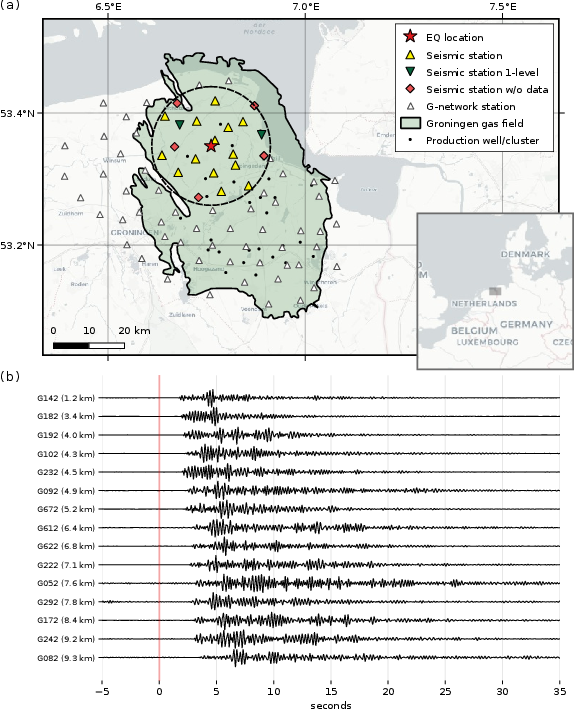
Since 1991, induced earthquakes are observed in connection with gas production in the Groningen field (The Netherlands). We introduce a method for probabilistic source mechanism estimation and demonstrate its use based on a single event within the Groningen field with the aim to derive rules of good practice for this region. By using full waveforms, we avoid difficulties in identifying seismic phases. Employing a probabilistic approach, we map uncertainties in the solution, which are commonly rarely reported. In addition to the source mechanism, event locations are provided, potentially allowing to relate earthquakes to specific faults. The analysed event shows traits of an implosion and may be interpreted as normal fault and collapse at reservoir level.
| Bulletin of the Seismological Society of America, 110, 5, 2095-2111 | DOI: https://doi.org/10.1785/0120200099 |
Prompt elasto-gravity signals (PEGS) and their potential use in modern seismology.
Zhang, S., Wang, R., Dahm, T., Zhou, S., Heimann, S. (2020)
![[Translate to English:] Beispiele für bandpassgefilterte PEGS-Synthetiks in 700 km Entfernung östlich eines Erdbebens mit unterschiedlicher Momentstärke und Bruchdauer](/fileadmin/_processed_/9/5/csm_Zhang_Dahm_figure_2020_975975cbc3.jpg)
An earthquake generates a sudden rock-mass redistribution through fault rupture and generates seismic waves that cause bulk density variations propagating with them. Both processes induce perturbations in the gravity potential field whose signals propagate with the speed of light and therefore can arrive at remote stations earlier than the fastest elastic wave. In turn, the gravity perturbations generate secondary seismic sources everywhere within the earth, a part of which around the station can cause ground motion prior to the direct seismic wave arrival there, too. Recently, these so-called prompt elasto-gravity signals (PEGS) of large seismic events like the 2011 Mw 9.1 Tohoku earthquake have been detected using the data recorded by broadband seismometers and superconducting gravimeters. Though the physics of the PEGS has been well understood, the tools used so far for a realistic modelling of them are complicated and computationally intensive. In this study, we present a new and straightforward approach that solves the full-coupled elasto-gravitational boundary-value problem more accurately, but no more complicated than to compute synthetic seismograms in a conventional way. Using the new tool, we simulate the complete PEGS of the 2011 Tohoku earthquake based on a kinematic finite-fault source model. Furthermore, we discuss the implications and the potential uses of PEGS in modern seismology. As an example, we show particularly that the major source parameters like the moment magnitude, the rupture duration and the focal mechanism of a megathrust earthquake can be estimated robustly using the measured PEGS data.
| Earth and Planetary Science Letters, 536, 116150 | DOI: https://doi.org/10.1016/j.epsl.2020.116150 |
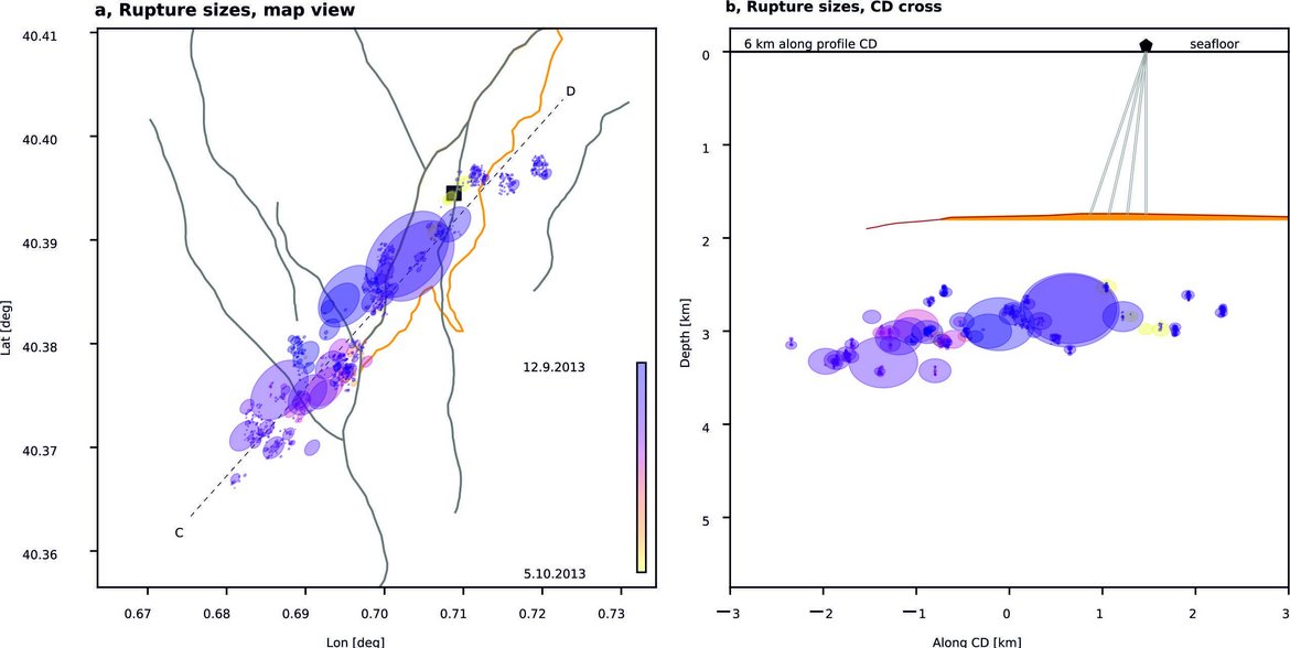
Drainage of a deep magma reservoir near Mayotte inferred from seismicity and deformation.
Cesca, S., Letort, J., Razafindrakoto, H., Heimann, S., Rivalta, E., Isken, M. P., Nikkhoo, M., Passarelli, L., Petersen, G., Cotton, F., Dahm, T. (2020)
The dynamics of magma deep in the Earth’s crust are difficult to capture by geophysical monitoring. Since May 2018, a seismically quiet area offshore of Mayotte in the western Indian Ocean has been affected by complex seismic activity, including long-duration, very-long-period signals detected globally. Global Navigation Satellite System stations on Mayotte have also recorded a large surface deflation offshore. Here we analyse regional and global seismic and deformation data to provide a one-year-long detailed picture of a deep, rare magmatic process. We identify about 7,000 volcano-tectonic earthquakes and 407 very-long-period seismic signals. Early earthquakes migrated upward in response to a magmatic dyke propagating from Moho depth to the surface, whereas later events marked the progressive failure of the roof of a magma reservoir, triggering its resonance. An analysis of the very-long-period seismicity and deformation suggests that at least 1.3 km3 of magma drained from a reservoir of 10 to 15 km diameter at 25 to 35 km depth. We demonstrate that such deep offshore magmatic activity can be captured without any on-site monitoring.
| Nature Geoscience, 13, 1, 87-93 | DOI: https://doi.org/10.1038/s41561-019-0505-5 |