TIPAGE - Seismology
The multi-disciplinary Tien Shan - Pamir Geodynamic program (TIPAGE) aims to exploit the Pamir, the western part of the Pamir-Tibet-Himalaya orogenic system, to address key questions in the geodynamics of continental collision and subduction: I.e. does the Earth’s most spectacular active intra-continental subduction zone beneath the Pamir and Hindu-Kush trace a single, partly overturned and distorted slab or two or more separate slabs? Are these slabs composed of continental lithosphere? What is the relationship between these slabs (mantle deformation) and deformation in the crust and at the surface? Why are there intermediate-depth continental subduction zones present beneath the Pamir and not elsewhere in the collision zone, e.g. beneath Tibet and the Himalaya? What is the mechanism of plateau formation in the eastern Pamir?
PIs: B. Schurr (sec 4.1), X. Yuan (sec 2.4), J. Mechie (sec 2.2)
PhD students: C. Sippl (sec 4.1), F. Schneider (sec 2.4)
Partners: Geological Institute Tajik Academy of Sciences, Dushanbe, Tajikistan, PMP Int. Dushanbe, Tajikistan, Central Asian Institute of Applied Geosciences, Bishkek, Kyrgyzstan
Funding: Deutsche Forschungs Gemeinschaft and GFZ expedition funds
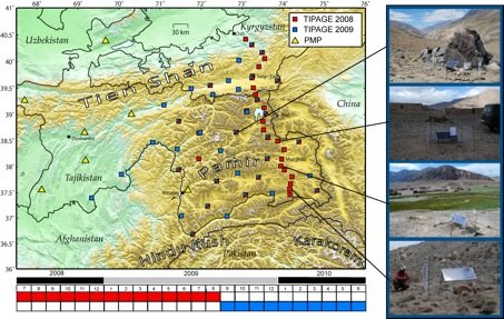
To tackle these issues we deployed a network of 40 temporary seismological stations in summer 2008 across the Tien Shan and Pamir mountain ranges in Kyrgyzstan (10 stations) and Tajikistan (30 stations). 24 of these stations form a north-south profile along the road from Osh in Kyrgyzstan via Sarytash, the Kyrgyz-Tajik border, Karakul and Murghab to Zorkul in southern Tajikistan with approximately 15 km station spacing. The N-S transect will produce a high resolution receiver function image to map the gross crustal and lithospheric structure. The other 16 stations are set up in a network configuration covering most of the Pamir Mountains and allowing location of local seismicity. In summer 2009, we dismantled the profile in order to increase the density of the 2-D seismic network. The new configuration covers the entire central Pamir with an average station spacing of approximately 40 km. The 2D network will allow high resolution location of local seismicity and 3D tomography of seismic velocity and attenuation.