Helmholtz Young Scientist Group
Information and Modelling Systems for Management of Large-scale Flood Events
The Helmholtz-Juniour Scientists Group analyses the flood statistics and develops the information and modelling tools for flood hazard and risk assessment in large river basins on example of the Elbe catchment. The complete process chain: „meteorology – hydrology – hydrodynamics – geotechnics – inundation – damage and risk estimation“ should be considered. The Junior Scientists Group is a project in a framework of CEDIM – Center for Disaster Management and Risk Reduction Technology – a virtual institute of Helmholtz-Zentrum Potsdam Deutsches GeoForschungsZentrum and University of Karlsruhe .
Project Description
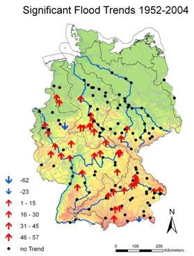
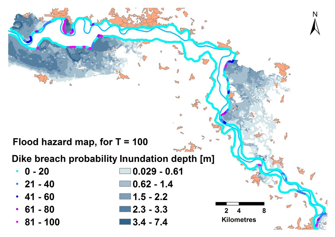
In a framework of the Helmholtz-Junior Scientists Group the flood triggering large scale atmospheric circulation patters are being analysed for the Mulde catchment. The weather regimes are being identified that are responsible for extreme floods in different seasons. Moreover, the country-wide gauge record analysis reveals and quantifies the significant trends in annual maximum discharge (Fig. 1). Especially, considering the climate change this information can be of high importance. A comprehensive modelling of flood events – from generation to damage - should be accomplished in several steps. The concept of the developed modelling system encompasses the application of five different models. The hydrological model J2000 (Krause, 2000) simulates the rainfall-runoff processes on a basis of hydrological response units. The setup of the hydrological model enables, among others, an evaluation of the future climate scenarios in terms of flood frequency and magnitude. The meteorological and hydrological data are being collected, homogenized and regionalized before used as input data in the hydrological model. In order to assess and present cartographically the flood hazard and risk along the diked river reaches, a 1D hydrodynamic model for a river channel was coupled with a probabilistic dike breach and 2D storage cell inundation model. The system is capable to simulate the flood wave propagation in a river channel and resulting inundation under consideration of dike failures. The unsteady modelling of a flood propagation and innovative probabilistic consideration of dike breaches due to overtopping, piping and slope micro-instability provide a methodological basis for generation of probabilistic flood hazard maps. (Fig. 2). The uncertainties in flood intensity indicators are analysed in a Monte Carlo simulation. On example of the Mulde River the „Probable Worst Flood“ is simulated with the hydrological and hydraulic models, in order to assess the impact of a possible hydrological extreme. Furthermore, a quasi-2D polder model (1D hydrodynamic model DYNYD (Ambrose et al., 1993) with a 2D discretization of polder) is implemented on the middle Elbe reach. It simulates the capping of a flood peak as a consequence of planned polder activation. The consequences of the polder management during the flood event should be evaluated with the coupled 1D-dike breach-2D modelling system in term of the hazard reduction for the downstream areas. Here the optimal polder operation strategies are provided as an input.