Sea Level Climate Change Initiative (SLCCI) project orbits
Homogeneous, precise orbits of altimetry satellites derived in the same reference frame using consistent precise background models and standards are very important to avoid possible inconsistencies in the derived sea level products caused by using different reference frames and models.
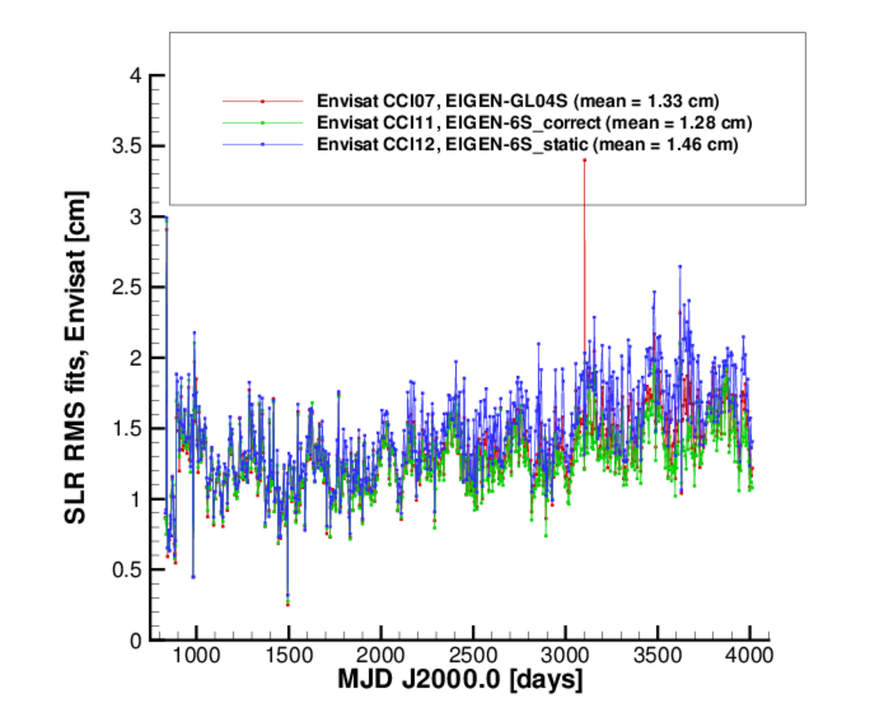
Therefore, new precise orbits of Envisat (Environmental Satellite, from April 2002 to December 2010), European Remote Sensing Satellites ERS-1 (from August 1991 till July 1996), ERS-2 (from May 1995 till July 2003) and TOPEX/Poseidon (from September 1992 till October 2005) have been computed at GFZ in the same terrestrial reference frame (ITRF2008) for all satellites using consistent models based mainly on the IERS Conventions (2010) within the Sea Level project of the European Space Agency (ESA) Climate Change Initiative (http://www.esa-sealevel-cci.org/). Three versions of orbits were generated for each satellite using three different Earth gravity field models – time-variable EIGEN-GL04S and EIGEN-6S and static EIGEN-6S ones.
The orbits are computed using the Earth Parameter and Orbit System - Orbit Computation (EPOS-OC) software for precise orbit determination and the Altimeter Database and processing System (ADS) both developed at GFZ for altimetry crossover data computation and altimetry analysis of the orbits. Satellite Laser Ranging (SLR) and altimeter crossover data were used for ERS-1, additionally Precise Range And Range-rate Equipment (PRARE) measurements were utilized for ERS-2 and SLR and Doppler Orbitography and Radiopositioning Integrated by Satellite (DORIS) observations were applied for Envisat and TOPEX/Poseidon.
The SLCCI orbits are available via ftp at
ftp://ftp.gfz-potsdam.de/pub/home/kg/orbit/SLCCI.
GFZ SLCCI orbits show improved orbit quality, as compared to previous GFZ orbit solutions. For example, ERS-1 and ERS-2 SLCCI orbits give 2.3 and 2.8 mm smaller RMS of crossover differences than GFZ REAPER orbits. The mean value of SLR RMS fits is 1.28 cm for Envisat CCI11 orbit derived using the time-variable EIGEN-6S geopotential model (see Figure). New orbits of Jason-1 and Jason-2 are also computed within this project. More information on the SLCCI orbits can be found in the following presentation.
Rudenko, S., Esselborn, S. and Schoene, T. New orbits of ERS-1, ERS-2, Envisat and TOPEX/Poseidon in the ITRF2008 reference frame and their use for mean sea level research. Presentation given at the Symposium "20 Years of Progress in Radar Altimetry", Venice-Lido, Italy, 24-29 September 2012.


