The joint project SIMULTAN aims to develop and apply an early recognition system of sinkhole instability, unrest and collapse in Germany. For this purpose, we joint with a large number of research partners.
Website SIMULTAN
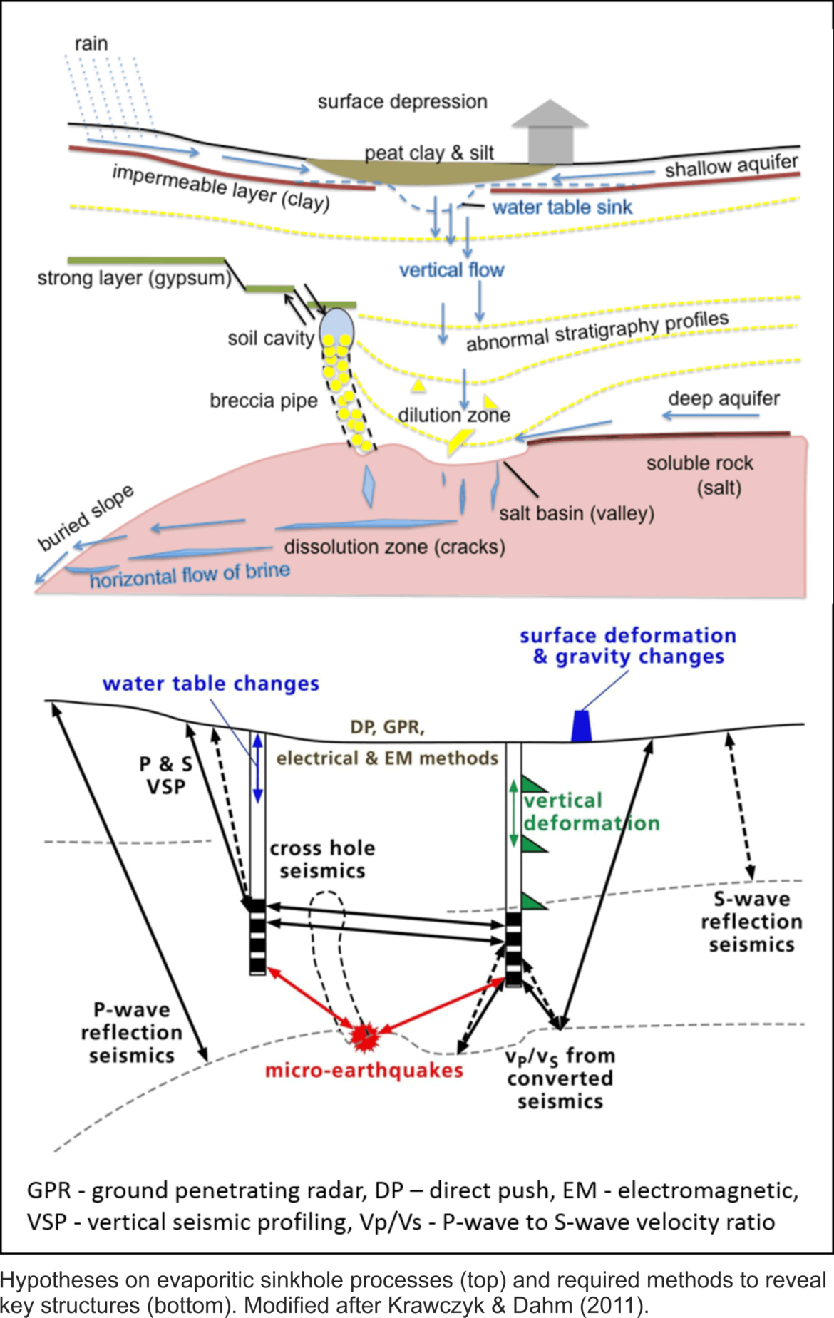
Sinkhole collapse processes generally occur in the uppermost few hundred meters of the Earth’s crust, and individual process components can in principle be simple and understood. However, pre-collapse processes and precursors interact on different spatio-temporal scales with small variation. This requires innovative, multi-scale observation, analysis and integrated early recognition concepts, especially for urban areas.

Two focus-areas are foreseen for pilot applications: area 1 in Hamburg, and area 2 in Thuringia, for which sinkhole unrest has been identified. These sites are representative of evaporitic sinkhole formation and are highly relevant since located in densely populated areas.
2016
- Al-Halbouni, D., Holohan, E.P., Saberi, L., Alrshdan, H., Sawarieh, A., Closson, D., Walter, T., Dahm, T., 2016. Sinkholes, subsidence and subrosion on the eastern shore of the Dead Sea as revealed by a close-range photogrammetry survey. Geomorphology, in revision.
- Gudmundsson & 47 others, 2016. Gradual caldera collapse at Bardabunga volcano, Iceland, regulated by lateral magma outflow. Science, 353, 6296; doi.org/10.1126/science.aaf8988. (numerical modeling approach has contributed)
- Kaufmann, G., Romanov, D., 2016. Structure and evolution of collapse sinkholes: Combined interpretation from physico-chemical modelling and geophysical field work. J. Hydrol., 540, 688-698; dx.doi.org/10.1016/j.jhydrol.2016.06.050.
- Kersten, T., Kobe, M., Timmen, L., Gabriel, G., Schön, S., Vogel, D., 2016. On Integrated Geodetic Monitoring of Sinkhole-Induced Surface Deformation and Mass Dislocation by Levelling, Gravimetry and GNSS - Preliminary Report. Journal of Applied Geodesy, in revision.
- Wadas, S., Polom, U., Krawczyk, C.M., 2016. High-resolution shear wave reflection seismics as tool to image near-surface subrosion structures – a case study in Bad Frankenhausen, Germany. Solid Earth, accepted; doi:10.5194/se-2016-91.
2015
- Dahm, T., Heimann, S., Cesca, S., Holohan, E., Al-Halbouni, D., Jousset, P., 2015. Beiträge der Seismologie zur Untersuchung der Bruchmechanik von Erdfällen, Stollen- und Kaldera-Einstürzen. In: Fechner, T., Litwinska-Kemperink, T., Joswig, M., Orlowsky, D., Schuck, A., Yaramanci, U. (Ed.): DGG-Kolloquium Georisiken-Erdfälle, DGG Sonderband I/2015, pp. 31-48.
- Kaufmann, G., Romanov, D., 2015. Numerische Modellierung von Verkarstung, Hohlraumbildung und Erdfallstrukturen am Beispiel eines Erdfalls im Gipskarst. In: Fechner, T., Litwinska-Kemperink, T., Joswig, M., Orlowsky, D., Schuck, A., Yaramanci, U. (Ed.): DGG-Kolloquium Georisiken-Erdfälle, DGG Sonderband I/2015, pp. 5-18, ISSN 0947-1944, Deutsche Geophysikalische Gesellschaft (DGG).
- Krawczyk, C.M., Polom, U., Buness, H., 2015. Geophysikalische Schlüsselparameter zur Überwachung von Erdfällen – Stand und Ziele der aktiven Seismik. In: Fechner, T., Litwinska-Kemperink, T., Joswig, M., Orlowsky, D., Schuck, A., Yaramanci, U. (Ed.): DGG-Kolloquium Georisiken-Erdfälle, DGG Sonderband I/2015, pp. 19-30, ISSN 0947-1944, Deutsche Geophysikalische Gesellschaft (DGG).
2011
- Krawczyk, C.M. & Dahm, T., 2011. Charakterisierung und Überwachung von Salz-bezogenen Erdfällen in urbanen Gebieten. White Paper, www.liag-hannover.de.
- Helmholtz-Zentrum Potsdam, Deutsches GeoForschungsZentrum GFZ,
Charlotte Krawczyk, Torsten Dahm, Eleonora Rivalta, Djamil, Al-Halbouni - Leibniz-Institut für Angewandte Geophysik (LIAG), Hannover
Gerald Gabriel, Ulrich Polom, Saskia Tschache, Adelheid Weise - Gottfried WilhelmLeibniz Universität Hannover (LUH),
Steffen Schön, Ludger Timmen, Tobias Kersten - Universität Hamburg (UHH),
Dirk Becker, Ali Dehghani, Klemen Zaksek - Technische Universität Berlin (TUB),
Frank Börner, Carsten Rücker, Franziska Mai - Freie Universität Berlin (FUB),
Georg Kaufmann, Douchko Romanov - GGL Geophysik und Geotechnik Leipzig GmbH (GGL),
Andreas Schuck - Helmholtz-Zentrum für Umweltforschung GmbH – UFZ, Leipzig,
Ulrike Werban, Thomas Vienken, Thomas Tippelt - Behörde für Umwelt und Energie (BUE), Hamburg,
Renate Taugs, Alf Grube, Doris Bunge - Thüringer Landesanstalt für Umwelt und Geologie (TLUG), Weimar, Lutz Katzschmann, Ina Pustal, Sven Schmidt
- Landesamt für Landwirtschaft, Umwelt und ländliche Räume (LLUR), Flintbek,
Reinhard Kirsch, Thomas Liebsch-Dürschner

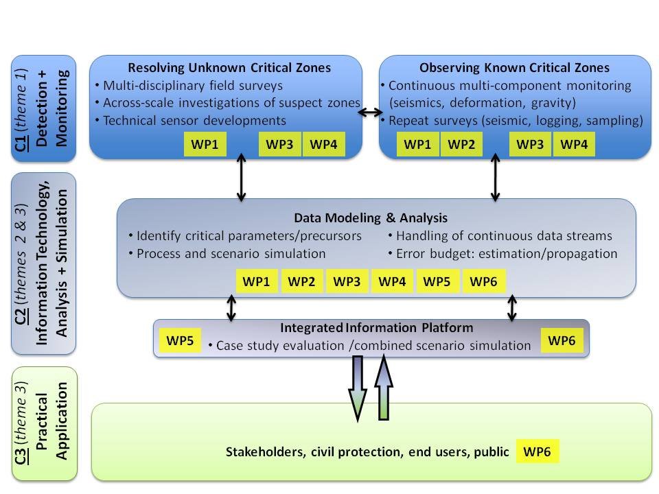
Our meshed concept comprises six inter-connected workpackages (WPs) that investigate large to small scale phenomena, consider time-dependent data, and combine different field data types with simulations for process understanding:
- WP1: key properties of critical zones in sinkholes (LIAG),
- WP2: seismic monitoring and characterisation (UHH, GFZ, LIAG),
- WP3: surface deformation and mass dislocation (LUH, GGL, LIAG),
- WP4: rock-soil-water interaction (TUB, UFZ),
- WP5: sub-surface cavity and collapse evolution (GFZ, FUB),
- WP6: protocols and decision process (geological surveys BUE, LLUR, TLUG).