

Goals
The Agulhas Karoo Geoscience Transect covers the southern margin of South Africa, from the oceanic Agulhas Plateau, across the Falkland-Ahulhas Shear Zone that dominates the sharp continent-ocean boundary, the continental shelf, and extends some 240 km inland, where it crosses the Cape Fold Belt (CFB) and the Karoo basin with its underlying, ca. 1 billion year old Kibaran (~Grenville in N America) basement. Close to the boundary between the Namaqua Natal Mobile Belt (NNMB) and the CFB, is the Beattie Magnetic Anomaly (BMA) - the world's largest onshore crustal magnetic anomaly and the Southern Cape Conductive Belt (SCCB), with their enigmatic sources buried below the Karoo (see map).
Onshore wide angle seismics
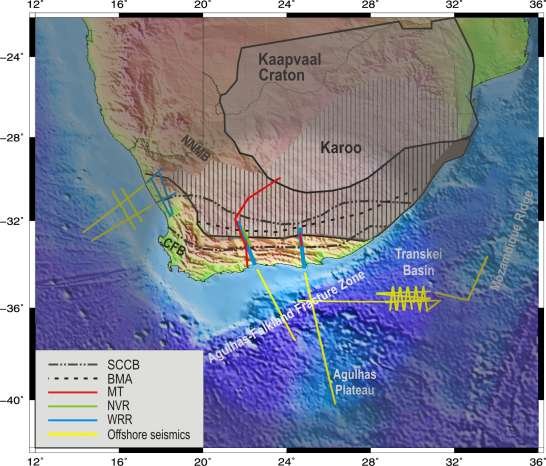
The onshore seismic data were recorded in two refraction seismic lines in 2004, each with a length of 240 km. Both the western (George, Prince Albert, Fraserburg) and eastern (St. Francis, Steytlerville, Graaf Reinet) profiles continue from the shore into the Karoo Basin. Among the aims of the project were identification of sources of the Beattie Magnetic Anomaly and the Southern Cape Conductive Belt, detailing the tectonic history of the Cape Fold Belt, and supplying new insights into break-up of Gondwana along Africa's Southern margin.
Along each profile 48 seismic stations were used to record data, each station consisting of a GPS synchronised, 24-bit seismic data logger and a three component seismic sensor. 13 shots were fired in boreholes along each profile. The quality of the collected data was very good. First (refracted P-wave) arrivals were manually picked for over 80% of the available traces. Tomographic inversion techniques were used to compute the P-wave velocity structure beneath the profile. The available ray coverage allowed for measurement of seismic velocities down to depths of 30 km. Reflected phases were also analysed - these allowed for the calculation of the Moho depth, as well as positions of crustal reflectors.
The profiles partially coincide with magnetotelluric profiles, which enables correlation of different measured parameters. They were also extended off-shore by AWI, increasing the ray penetration, especially beneath the coast.
Projektverantwortliche
- Jacek Stankiewicz (GFZ Potsdam)
- Albrecht Schulze
- Trond Ryberg (GFZ Potsdam)
- Klaus Bauer (GFZ Potsdam)
- Michael Weber (GFZ Potsdam)
Publications
- Stankiewicz, J., Parsiegla, N., Ryberg, T., Gohl, K., Weckmann, U., Trumbull, R., Weber, M. (2008): Crustal structure of the southern margin of the African continent: Results from geophysical experiments, J. Geophys. Res., 113, B10313, doi:10.1029/2008JB005612.
