DEad Sea Integrated REsearch Project / Magnetotellurics
Abstract
The left-lateral Dead Sea transform (DST) is a major transform fault that separates the Arabian plate in the east from the African and Sinai plates in the west. It extends from Red Sea rift in the south to the Taurus collision zone in eastern Turkey, with a total length of more than 1000 km (Fig. 1). The total displacement along the fault is estimated to about 105 km since its development ~18 Ma ago with an average slip rate of 4mm/yr.
During its evolution, the DST formed several deep sedimentary basins. These pull-apart basins formed the Gulf of Aquaba / Eilat, lake of Tiberias and the Dead Sea basin (DSB). The DSB is probably the largest of these structures on earth.
Geophysical, geological and geochemical studies of the San Andreas Fault system in California showed clearly that the dynamics and thereby earthquake generation processes are closely linked with (over-pressurized) fluids. In addition to meteoric water and formation water, fluids may originate from deep as the earth’s mantle. At the DST, the existence of several hot springs on both sides of the fault may indicate deep-reaching fault zones that provide pathways for fluids. The main objectives for the MT experiment are:
- To determine position and depth extent of the major faults within the DS basin
- To establish if these fault zones are associated with deep reaching fluid channels.
- To infer the thickness of sediments within DS basin and to image the internal structures of the DS basin.
Experiment design and Data processing
In the framework of the multi-disciplinary DESIRE (Dead Sea Integrated Research) project, several geophysical methods were applied to investigate the southern part of the Dead Sea basin. Besides MT, the methods used included active reflection and refraction seismic, aero-gravity, passive seismology, and thermo-mechanical modeling.
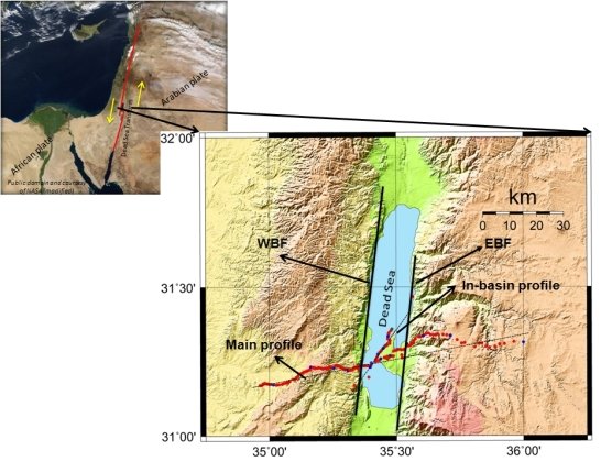
The MT profile in Figure 1 follows roughly the seismic profiles, crossing the DST at the place where the fault separates into an eastern and western border fault (EBF and WBF), where the basin fill is at its largest and where intruded salt domes are likely three-dimensional features.
The data were collected in October and November 2006. The measurements were carried out along two profiles. The main profile is oriented N70°E, approximately perpendicular to the surface trace of the DST and has a length of ~110 km. A second, shorter profile (20 km) is oriented N20°E and runs parallel to the west coast of Al Lisan peninsula (Fig. 1). With the in-basin profile we intend to quantify the effect of the highly conductive Dead Sea brines ("ocean" effect) but also to test if structural details within the sedimentary basin can be resolved.
Data acquisition was accomplished with two independent teams, working at the same time in Jordan and Israel which allowed us to operate up to 30 sites recording simultaneously. This provides great flexibility to use remote reference processing with many combinations of sites.
In total, 148 MT stations were deployed along the profiles with denser site spacing within the Dead Sea basin and increased site spacing towards both ends of the profile.
At each site, broad-band systems (red dots in Fig. 1, period range 0.001s-1000s) were used to measure time variations of the orthogonal magnetic (Bx, By, Bz) and electric (Ex, Ey) field components. Additionally, 20 sites with long-period systems (10 s – 10000 s) were distributed along both profiles (blue dots in Fig. 1).
The recorded time series were processed using the EMERALD to compute the horizontal impedance tensor and vertical magnetic transfer functions. In addition, remote reference processing was useful to improve the data quality at particularly noisy sites.


