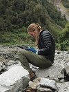
The high resolution topography lab contains a wide collection of equipment and software for the acquisition and processing of high resolution topographic data based on terrestrial laser scanning (TLS, LIDAR), Structure from Motion (SfM), and differential GPS (dGPS). Repeat surveys of active landscapes enable precise measurements of small changes in the topography: We can investigate magnitudes and patterns of surface processes such as fluvial erosion and deposition, rockfalls, landslides, and debris flows.
- a rapidly eroding bedrock gorge in western Taiwan
- a steep rock wall in the Reintal Valley , Germany
- the cliff coast in Jasmund National Park, Germany
- alluvial fans and fault scarps in Argentina
- landslides in Taiwan and New Zealand
- river terraces in Upper Mustang, Nepal
- river cross sections for hydrological modeling in Nepal and Taiwan
- volcanoes in Indonesia, Iceland, and Cape Verde (in cooperation with Section 2.1)
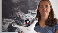
GFZ: How did you become a drone pilot?
Kristen Cook: I started working with topographic data almost ten years ago, using terrestrial LiDAR. A LiDAR sends out a laser pulse that is reflected back to the instrument. So it gives you a very accurate 3D-picture of a location. But it is a very expensive instrument and quite heavy - you need several people to use it in the field.
GFZ: Drones are less complicated to handle?
Cook: Yes, so I was excited when I learned about drones and the things you could do with them, when on a field trip in 2014 a colleague brought a drone with him. Without any of us really knowing how to use them, we were already able to produce nice areal 3D-pictures. That was amazing and so back home I bought my first drone.
GFZ: You not only take pictures with a drone but also produce 3D-landscape models. How does that work?
Cook: For a long time now it is possible to produce 3D-pictures using aerial photographs taken from planes, just by having pictures with enough overlap. It is basically the same way that your eyes produce a 3D-view: You get 3D-images just by having a stereo-view.
But you need a lot of information with the photographs: the exact point where a picture was taken from, everything about the used lens, because it gives a distortion to a photo that you need to remove, and you need a very precisely calibrated camera.
Now the big advance was the development of a software that allows to automatically identify scale invariant features in a photograph. It allows you to reconstruct the location from where a photograph was taken or estimate the parameters of the camera. And, most important, it automatically identifies objects that are seen in different photographs from different angles to get 3D-landscape models. It is kind of magical.
GFZ: Is there a GPS included in a drone for positioning?
Cook: Depending on which kind of drone you have they have a GPS installed, so each photograph gets a GPS-tag. This helps a lot because you then exactly know where each photo was taken. Without GPS you need to have some independent ground control points. Otherwise you can still make a model but there is no scale. Most of the time you find parts that do not move from one overflight to the next. If there is too much change that does not work, however, and you need GPS-control.
GFZ: What are the scientific questions that you address using drones?
Cook: In geomorphology we want to know things about the surface of the Earth. I am most interested in how it changes, for example due to erosional or depositional processes. So I do a lot of time series with drone surveys and then calculate the changes, for example in river gorges.
Drones are not only useful to produce 3D-landscape models but also just for the images itself. You can use them for mapping and the observation of landforms. If you want to know how deep a valley is, or count the number of fallen trees, just fly the drone over.
GFZ: How do you steer a drone?
Cook: For the quadcopters it is really easy to fly them. For the fixed-wing drone, that we also have in our working group, the only way to fly it is the programmed way which is the big limitation for this drone. You program in the flight path and tell it where and when it is supposed to land and then just throw it in the air and wait for it to come back. For the quadcopters I also do use the flight programming, depending on the field area. If it is relatively flat than it works fine. But in steep mountain areas it may be better to fly it manually.
GFZ: What do you think about the future of the field?
Cook: That is a difficult question. On the technological site things are great. The technology is constantly improving, sensors are getting better and cheaper, and there is more and more you could do with them in science.
Increasing regulation is a huge challenge, however. The legal aspects are getting more and more difficult in more and more countries of the world. Since drones became more popular, especially with non-scientists and people who don’t know what they are doing, or might be using them for not so good purposes, many countries are really restricting.
GFZ: What does it mean for your work?
Cook: In Nepal, for example, where we do a lot of research on landslides, after the earthquake in 2015 the government banned drone flying in the whole country. They did it because in Katmandu a lot of journalists were flying drones to take pictures of earthquake destruction and thereby did things like flying into the area of the presidential palace or the territory of the American embassy. So Nepal implied a complex and time-consuming process to require people to get permits. So far they have denied our applications, so we just can’t go on with our research there.
GFZ: You work together with Michael Dietze on the Jasmund project. It was said that some future goal may be to implement a continuous monitoring of the area. What do you think about this as a drone specialist?
Cook: There is still a bit of technology to work out constant monitoring and have the drones really autonomously flying. But if you could have it completely remotely and autonomously flying and recharge it batteries by itself, then it would be really easy to have constant records for monitoring.
GFZ: What’s next?
Cook: I think drones will be involved in everything that I do. I have this project in western Taiwan which is pretty much entirely drone-based. We also just started a big erosion observatory in eastern Taiwan to monitor changes in a river system for about the next ten years, and have just installed several seismic and weather stations. A future aim would also be to have drones combined with a LiDAR to get higher resolution landscape models.
13.09.2017, Interview: Ariane Kujau

The Riegl VZ 6000 is an ultra long range scanner, with a possible range of 6 km, the capability to detect snow and ice, and a built-in camera. The scanner records multiple returns, making it suitable for vegetated areas. Our setup includes a custom made tilt mount for scanning steep terrain, extended-capacity batteries, and a set of reflective targets.
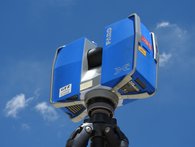
The Faro Focus X330 is a compact lightweight short-range scanner with a range of 330 meters. Our setup includes a lightweight carbon-fiber tripod, a set of target spheres, and two spare batteries.

The Phantom 3 Advanced is a robust quadcopter with a 12 megapixel camera and a flight time of 18-20 minutes. We also have several older Phantom 2 drones suitable for training.
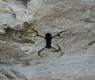
The very portable folding Mavic Pro quadcopter with a 12 megapixel camera has a long range of several kilometers, and a flight time of 20-22 minutes.
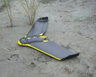
The eBee by Sensefly is a fixed wing UAV with a long range and flight time of 40 minutes, suitable for automated mapping of larger areas. We have an RGB camera, a NIR camera, and a red edge camera that can be flown with the eBee.
Differential GPS
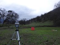
We have four Trimble R10 GNSS receivers that can be used interchangeably as base stations or rovers. Each receiver can be used independently with Virtual Reference Station (VRS) or satellite-based corrections, or the receivers can be combined to make two full sets of base-rover pairs. We have two Slate controllers with extended battery packs, a range extender, and three external batteries for long base station operation. The R10 receivers are also compatible with our Sontek ADCP system.
Acoustic Doppler Current Profiler (ADCP)
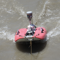
The Sontek ADCP system emits sound waves through the water. Particles inside the water reflect these sound signals back to the device. The backscattered signal is detected by sensors. The travel time of the sound allows calculation of the depth and hereby a measuring of the bathymetry. Movement of particles and objects in the water column cause variations in the backscattered frequencies. This variation in frequency is called the Doppler effect. The ADCP is able to calculate the speed of the water by retaining the Doppler effect as a function of depth. Knowing the water speed, and the measured area, the program operating the ADCP is able to calculate the discharge in the measured section.
Data Processing
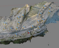
We have a dedicated workstation optimized for the processing of lidar and SfM data, with 64 GB of RAM, two GeForce GTX 980 GPUs, and dual Xeon 1.6 GHz processors. Our software includes: RiScan Pro (processing Riegl scanner data), Faro Scene (processing Faro scanner data), Pix4D (SfM processing), Agisoft Photoscan Pro (SfM processing), and Trimble Business Center (GNSS processing).


