

- What is the geomagnetic field?
- What is the origin of the geomagnetic field?
- Does the geomagnetic field change with time?
- What is secular variation?
- What is a geomagnetic reversal?
- What is a magnetic storm?
- How do we measure the geomagnetic field?
- How strong is the geomagnetic field?
- How is the geomagnetic field described?
- What are magnetic field models?
- What are declination, inclination and the magnetic equator?
- Where are the magnetic poles?
- How does a magnetic compass work?
- Since when do we measure the geomagnetic field?
- How do we know about geomagnetic reversals?
- Does the geomagnetic field influence humans?
- When will the next reversal happen?
What is the geomagnetic field?
The Earth is surrounded by a magnetic field, which can be approximated by a dipole field, like that of a bar magnet with a northern and a southern pole. The poles of the magnetic field do not coincide with the geographic poles. The axis of the approximate dipole is tilted by about 10 degrees compared to Earth's rotation axis. The geomagnetic field surrounds the whole Earth and shields it against the highly energetic particles of the solar wind approaching the Earth.
At a closer look large-scale deviations of the simple dipole structure become obvious. Like the strong dipole component these originate deep within the Earth, in the outer core. The geomagnetic field differs in strength and direction all over the globe, and it varies continuously. Permanent global observations are necessary to describe and understand the geomagnetic field.
What is the origin of the geomagnetic field?
Any measurement of the geomagnetic field at the Earth's surface originates from several sources. The largest contribution with more than 90% comes from the main or core field. This is produced by geodynamo processes in the outer fluid and electrically conducting Earth's core. Magnetized rocks in the crust near the Earth's surface cause the crustal or lithospheric field, which overlays the core field in the form of local to regional anomalies. These two contributions are the so-called internal field, due to their sources inside the Earth.
Moreover, there are external contributions which originate outside the Earth. These are magnetic fields induced by electric currents flowing in the ionosphere (about 100 to 300 km above the Earth) and the magnetosphere (in distances of 3 to 6 Earth radii) and constantly varying under the influence of insolation and solar wind. The external fields are much weaker than the core field (see also measuing the field), but they show strong variations. Thus the external fields additionally cause secondary induced fields in Earth's crust and mantle depending on the regional electrical conductivity. Even oceanic tides and currents show measurable effects in geomagnetic field observations due to the good electrical conductivity of sea water.
Does the geomagnetic field change with time?
Yes, it changes on a broad range of time-scales. The external fields show strong variations on the order of seconds to several days (magnetic storms). Long-term recordings also show seasonal variations. The main reasons are variations in the solar wind and the influence of insolation on the ionosphere. The core field also changes, but on longer time-scales (see secular variation).
What is secular variation?
The change of the core field is called secular variation because it happens on comparatively long time scales. In geomagnetic field recordings the secular variation only becomes obvious in time series of several years as a change in field strength and direction. Secular variation also causes a change in the location of the magnetic poles. On even longer time scales of millions of years the geomagnetic field has shown several polarity reversals.
What is a geomagnetic reversal?
On time scales of millions of years the geomagnetic field changed its orientation several times, so that today's magnetic north pole was the south pole. The process of reversing polarity supposedly takes some thousands of years. The reversal rate is very variable. On average it lies in the order of 0.5 million years over the past 160 million years. The exact process of a field reversal is not yet understood. The field intensity is lower during a reversal, and most likely the field shows a more complex structure with several poles during the reversal process, before the dipole strength increases with opposite polarity. The last polarity reversal occurred 0.78 million years ago.
What is a magnetic storm?
Magnetic storms occur when much more solar wind energy than usual enters the magnetophere as a consequence of increased solar activity. The interaction of this increased solar wind with the geomagnetic field leads to strong variations in magnetic recordings. Magnetic storms can have negative consequences for modern technology: they can e.g. lead to disturbances in radio communication, satellite outages and even power failures. In particular the occurrence of aurora increases during magnetic storms. This phenomenon usually occurs at high latitudes due to the dipolar character of the geomagnetic field. During strong magnetic storms aurora can occur in Southern Germany and even further south.
The level of magnetic field variation caused by solar activity is described by the Kp index. It was introduced in 1949 by Julius Bartels as planetary index (planetarische Kennziffer) for three hour intervals and still is widely used. The near real-time quicklook version informs about the present magnetic field variations. Kp values between 0 and 3 indicate low activity, values up to 6 characterize moderate activity and higher values (up to 9) represent strong magnetic storms.
See also: Selected Geomagnetic Storms, measured in observatory Niemegk (since 1995).
How do we measure the geomagnetic field?
The basis of global geomagnetic observations is a network of geomagnetic observatories that are operated by universities and research institutions worldwide. Continuous recordings of the geomagnetic field and its variations are provided by them. The oldest observatories have existed for 170 years. Aeromagnetic measurements carried out by aircraft are used to regionally map the crustal magnetic anomalies. Since 1999 near-Earth orbiting satellites provide global geomagnetic field observations of high accuracy.
How strong is the geomagnetic field?
The commonly used unit to describe the geomagnetic field strength is nanoTesla (nT), i.e. 10-9 Tesla. This is the unit of magnetic flux density, which is directly propotional to magnetic field strength.
At present the magnetic field intensity lies between 25.000nT at the equator and 70.000nT at the poles (see Fig. total intensity). Our declination calculator also provides he magnetic field strength for any point on Earth based on the IGRF (see magnetic field models). The crustal field only reaches a couple of 1000nT maximum at Earth's surface. The external field variations, which nearly average out over long time scales, have amplitudes of up to 100nT in general and a few 1000nT during strong magnetic storms.
Technical magnets are much stronger than the geomagnetic field. Very strong electromagnets can reach a few Tesla, that is more than 20,000 times the geomagnetic field strength. Any material that carries a magnetisation can therefore strongly disturb geomagnetic field observations.
![[Translate to English:] Totalintensität des Erdmagnetfeldes](/fileadmin/_processed_/4/2/csm_IGRF13_F-small_0e636823a8.png)
How is the geomagnetic field described?
Intensity and orientation are necessary to fully describe the geomagnetic field (see figure). Two angles, declination (D) and inclination (I) are commonly used to give the orientation together with the total intensity of the field. Another widely used representation consists of three orthogonal components in the directions of geographic north (X), geographic east (Y) and down into the Earth (Z).

The X and Y components are parallel to the Earth's surface and point towards the geographic north pole and geographic east, respectively. The vector F includes intensity and directions. H is its horizontal component parallel to the Earth's surface and pointing towards magnetic north. The vertical component (Z) points into the Earth perpendicular to H. The inclination (I) is the angle between H and F, i.e. the angle at which the magnetic field lines meet the Earth's surface. Declination (D) is the angle between magnetic (H) and geographic (X) north.
What are magnetic field models?
In order to describe the geomagnetic field for any location on Earth the field can be represented by mathematical functions which are fit to the global observations. Magnetic field strength and directions can be calculated for any point on Earth based on such a model, e.g. in order to determine the declination for the navigation by magnetic compass. A commonly used model is the the International Geomagnetic Reference Field (IGRF) which describes the core field and is updated every five years. Our declination calculator provides IGRF values for any point on Earth. Other, more sophisticated models are developed for scientific purposes. These e.g. also describe the long-term continuous secular variation or some of the external field contribution.
See also GFZ web page of geomagnetic field models.
What are declination, inclination and magnetic equator?
The angles of declination and inclination describe the orientation of the geomagnetic field (see vector model). Declination is the angle between the direction of the magnetic field lines and geographic north. Inclination is the angle by which the magnetic field lines meet the Earth's surface. Inclination is in general positive in the northern and negative in the southern hemisphere. The magnetic equator is the line where inclination is zero. The magnetic field is parallel to Earth's surface here. At the magnetic poles the inclination is 90 degrees. Figure 3 shows the global distribution of declination for 2015 according to the IGRF model. Our declination calculator provides declination and other magnetic field components for any location on Earth.
![[Translate to English:] Missweisung der Kompassnadel weltweit](/fileadmin/_processed_/2/7/csm_IGRF13_D-small_ee69cee41a.png)
Where are the magnetic poles?
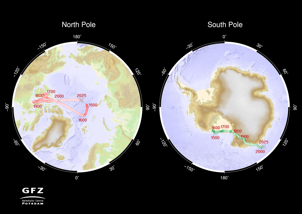
There is a difference between the magnetic and the so-called geomagnetic poles. The magnetic poles are the locations where inclination is 90 degrees, i.e. where the field is perpendicular to Earth's surface. The geomagnetic poles are the poles of a pure dipole field. Here, the axis of the approximated dipole field crosses the Earth's surface. Secular variation caused movements of magnetic and geomagnetic poles.
The northern magnetic pole lies at present (2021) in the Arctic, at about 86 degrees North and 160 degrees East. Currently it moves northward by about 40km per year. The southern magnetic pole lies at about 64 degrees South and 137 degrees East. It only moves by less than 15km a year. The exact position of the points where inclination measurements show 90 degrees, however, can vary by up to 80km within a day due to the external magnetic field contributions. The figure below shows the positions of magnetic poles in the northern and southern hemisphere since 1500.
How does a magnetic compass work?
The magnetic needle of a compass orients itself along the local magnetic field lines. This direction can deviate significantly from geographic north. Due to the fact that the geomagnetic field is not a pure dipole field it also is not correct to say "the compass needle points to the magnetic pole". The deviation has to be considered taking into account the local declination, which e.g. is provided for any point on Earth by global geomagnetic field models (see also declination calculator). However, these declination values are large-scale values. Strongly magnetized rocks can cause additional deviations of the compass needle, and during strong geomagnetic storms variations of the compass needle in the order of a few degrees can be observed at high latitudes. A compass needle additionally orients itself according to the inclination of the field lines. The compass needle has to be balanced accordingly.
Since when do we measure the geomagnetic field?
The declination of the compass needle was already known in the 15th century. Declination measurements were widely performed on ships for navigational purposes. Occasionally inclination measurements were also done since the 16th century. Carl Friedrich Gauss developed a method to measure the absolute intensity of the geomagnetic field in 1832. Alexander von Humboltd initiated the establishment of a global network of geomagnetic observatories at about the same time. About 200 geomagnetic observatories exist at present. Additionally the geomagentic field is monitored by low-Earth orbiting satellites since a few decades. In 1980 Magsat was the first satellite to measure both strength and orientation of the geomagnetic field for 6 months from space. The Danish satellite Ørsted is in orbit since 1999 and still provides intensity data today. From July 2000 to September 2010 the German satellite CHAMP provided high quality magnetic field data. The ESA satellite mission Swarm, consisting of a constellation of 3 identical satellites, was launched in Nobember 2013.
How do we know about geomagnetic reversals?
Rocks or archaeological artefacts can provide information about the geomagnetic field prior to the times of direct field observations. A permanent magnetization cannot exist above a certain temperature specific to each mineral, the so-called Curie-temperature. In lava or burnt clay the magnetization gets oriented along the geomagnetic field lines while the material is very hot, and gets "frozen in" when it cools down. Similarly, if magnetic grains get embedded into a sediment, they will get oriented along the field lines while they are still mobile, and will get fixed in that direction when the sediment gets compacted. Measuring the magnetization of such materials in the laboratory therefore can provide information about the direction and sometimes the strength of the geomagnetic field at the time when the sediment formed or the material cooled down. This is the subject of paleomagnetism.
Does the geomagnetic field influence humans?
We have no direct perception of magnetic fields. Several animals like pigeons, turtles, dolphins, tuna or bees, however, use the geomagnetic field among other methods for orientation. It is controversially discussed whether the geomagnetic field can influence the human body. Geomagnetic pulsations and oscillations during magnetic storms show frequencies that could play a role in the human body. A few studies exist that describe correlations between human behaviour and geomagnetic activity that might support some causal relations. However, the artificial electromagnetic fields in our environment are much stronger than most natural magnetic variations. Their influence on health and the human body also is a controversial issue.
When will the next reversal happen?
The global geomagnetic field strength has decreased by 10% over the past 170 years, since the beginning of systematic intensity observations. This is significantly faster than the field decay that would result if the geodynamo suddenly stopped working. It raises concerns whether we are experiencing the beginning of a magnetic reversal. If the decrease of the dipole strength and the also observed increase of small-scale field structure continued at today's rates we would experience a field with more than two poles at Earth's surface in about 1800 years. A constant change over such a time span seems unlikely. The investigation of field variations in the historical and geological past has shown that the rates of dipole change vary and in general are not constant over more than 1000 years. Moreover, global field intensity has been weaker than today for some time intervals in the past where no reversal occurred. The average reversal rate of 0.5 million years might suggest that the next reversal is overdue. On the other hand, the duration of 0.78 million years of the present polarity interval is by far not extraordinary given the strong variability of past reversal rates. Our understanding of the geodynamo processes in the core is not sufficient yet to make a definitive statement on the occurrence of the next polarity reversal.

Häufig gestellte Fragen
- Was ist das Erdmagnetfeld?
- Woher kommt das Erdmagnetfeld?
- Ändert sich das Erdmagnetfeld?
- Was ist die Säkularvariation?
- Was ist eine Feldumkehr (Reversal)?
- Was ist ein magnetischer Sturm?
- Wie wird das Erdmagnetfeld gemessen?
- Wie stark ist das Erdmagnetfeld?
- Wie lässt sich das Erdmagnetfeld beschreiben?
- Was sind Magnetfeldmodelle?
- Was sind Deklination, Inklination und magnetischer Äquator?
- Wo sind die Magnetpole?
- Wie funktioniert der Magnetkompass?
- Seit wann wird das Erdmagnetfeld gemessen?
- Woher wissen wir von Feldumkehrungen?
- Wie beeinflusst uns das Erdmagnetfeld?
- Steht uns eine Feldumkehr bevor?