

The city of Istanbul is focus of great concern for earthquake researchers. This 15-million metropole is situated very close to the so-called North Anatolian Fault Zone which runs just outside of the city gates below the Marmara Sea. Here in the underground there is a constant build-up of energy which results from an interlocking of the tectonic plates causing plate movement to come to a halt until a great tremor releases this energy. Scientists, therefore, reckon with an earthquake with a magnitude of 7 or greater in this region in the coming years.
The extent of such seismic threat to this Turkish city of Istanbul actually depends on how strongly the plates are entangled and on the exact nucleation point of the earthquake. A team led by Marco Bohnhoff from the GFZ German Research Centre for Geoscience now presents a study indicating that the next major earthquake is more likely to originate in Istanbul's eastern Marmara Sea. "This is both good news and bad news for the city with over 15 million inhabitants". The good news: "The rupture propagation will then run eastwards i.e. away from the city", explains the researcher. "The bad news is that there will only be a very short early warning phase of a few seconds." Early warning times are extremely important in order to switch traffic lights to red, to block tunnels and bridges or to shut down critical infrastructure. The research results are now published in the scientific journal Geophysical Journal International.
The estimations presented by Marco Bohnhoff and his team are based on the analysis of numerous small quakes along the Marmara fault. Results have shown that the degree of locking in the western part of the fracture zone is lower and that the two tectonic plates are creeping past one another at a very slow rate. During this process small tremors of the same signature, so-called "repeaters", occur at distinct recurrence times. Further east, close to Istanbul, however, repeaters have not been observed and the tectonic plates appear to be completely locked here. This leads to a build-up of tectonic energy and increases the probability of a large earthquake there.
Such observations were possible due to a new high-precision seismicity catalog for the region. For this purpose, the researchers have thoroughly evaluated the earthquake activity by combining the two major Turkish Earthquake Measurement Networks with measurement data from the GFZ Plate Boarder Observatory within the framework of a German-Turkish cooperation project. "In this way we have found recurring earthquakes below the western Marmara Sea" says Bohnhoff. "From this we deduce that below the western Marmara Sea the two tectonic plates (for the most part -- 25-75%) are moving slowly past each other thus accumulating less energy than if they were completely locked."
And what will happen if it actually comes to the feared strong earthquake below the western Marmara Sea? "In such a case there would likewise be good news and bad news," says Bohnhoff. Good would be a somewhat longer early warning period, bad would be the fact that the rupture propagation would then take place in the direction of Istanbul resulting in more severe ground shaking than if the origin was further east. However, the current data obtained suggests the opposite: an earthquake with an epicenter at the gates of the city, which would allow the people only very little time to find protection, but which would trigger less powerful ground movements.
Original study: Bohnhoff, M., Wollin, C., Domigall, D., Küperkoch, L., Martínez-Garzón, P., Kwiatek, G., Dresen, G., Malin, P.E., 2017. Repeating Marmara Sea Earthquakes: Indication for fault creep. Geophysical Journal International 169, DOI: 10.1093/gji/ggx169
-----
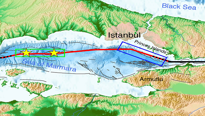
Map>>in a printable version:
Caption: Marmara Sea region in northwestern Turkey with the North Anatolian Fault Zone (NAFZ) separating Eurasia from Anatolian. The offshore Marmara fault where a major earthquake is overdue is indicated by the red line. The black lines to either side are the two last major ruptures of the region, the 1912 Ganos and the 1999 Izmit earthquakes. The Marmara section has not produced a large earthquake since 1766 but is know to rupture every ~250 years based on historical records. The yellow stars mark the repeating earthquakes found in the now published study indicating fault creep (green rectangle) while the fault portion offshore of Istanbul (blue rectangle) is locked.


![[Translate to English:] Hörsaal](/fileadmin/_processed_/e/6/csm_H%C3%B6rsal_f1d7c412b9.webp "[Translate to English:]")


