

In Switzerland, a severe landslide threatens the village of Brienz/Brinzauls (Graubünden). The slope has been moving for some time, and the GFZ has been collecting data on site for years. Niels Hovius in an interview about the developments and the GFZ-research there.
Background
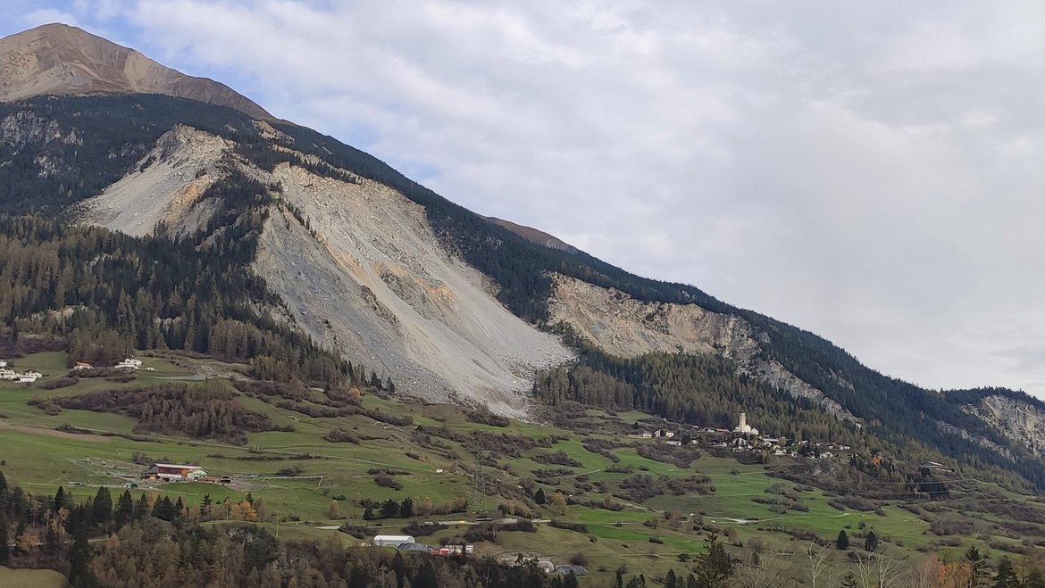
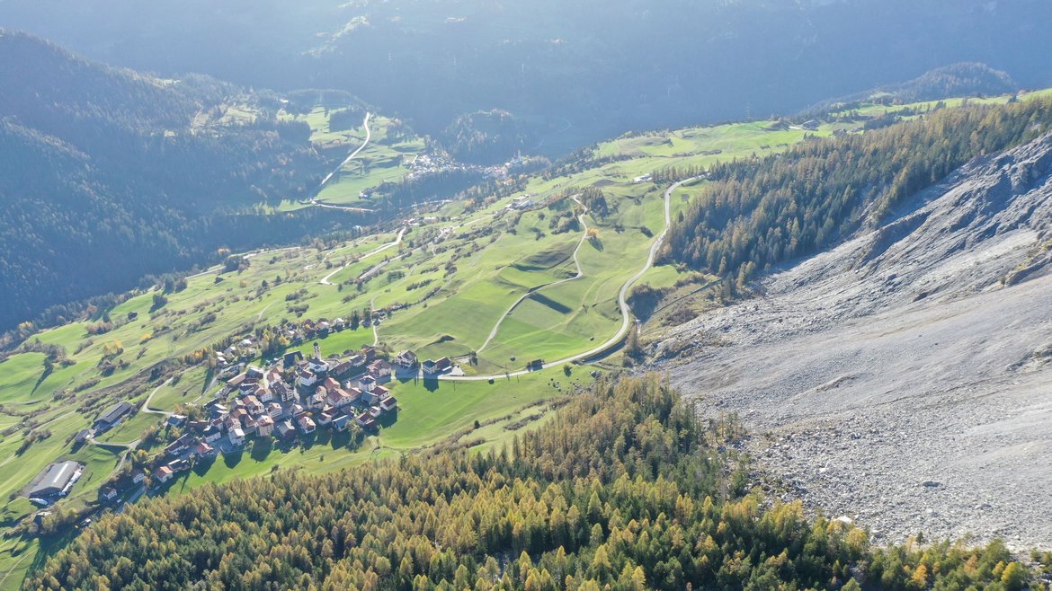
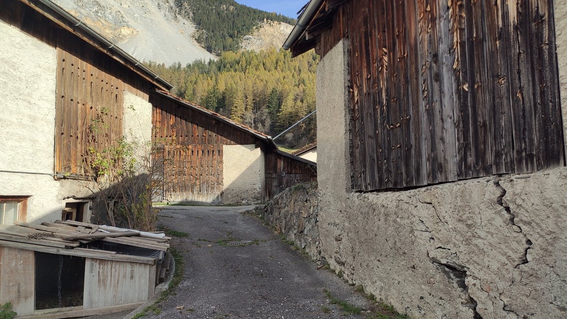
In the Swiss canton of Graubünden, the slope of the 2767-metre-high Piz Linard mountain above the village of Brienz/Brinzauls (municipality of Albula) has started to slide. In the next days to weeks, up to two million cubic metres of rock are in danger of tumbling towards the village, which corresponds to a cube with an edge length of 126 metres. Although this is unlikely to happen in one giant release, the 84 inhabitants of the village on the Brienzer Terrasse at the foot of the mountain have been evacuated to avoid casualties.
A research project of the GFZ German Research Centre for Geosciences has been collecting data on site for several years, with academic partners in Switzerland. The project, initiated by Michael Dietze, is overseen by Niels Hovius, head of GFZ-section 4.6 ‘Geomorphology’. Parts of the team now work elsewhere, at the University of Göttingen (Michael Dietze) and the ISTERE of the Université Grenoble-Alpes (Kristen Cook). Currently, the team are expanding their instrument network around the site to catch the hot phase of this crisis in as much detail as possible.
Interview
Niels Hovius, you and your team have been researching on the mountainside above Brienz for two and a half years. Why is this an interesting area?
The entire structure to which the slope belongs has probably been in motion since the end of the last ice age more than 10,000 years ago, when valley sides steepened by glaciers were freed from their ice load and undercut by rivers. There have been many major landslides in this region, throughout lived history. For example, in 1877 the so-called ‘Igl Rutsch’ landslide displaced around 13 million cubic metres of rock mass, more than six times the current volume. That landslide was a slow movement, lasting several weeks. The slide did not end in a steep slope, but connected directly to the gentler slope of a terrain step or terrace, on which the village of Brienz is built. This was probably a reason why it did not result in a fast-moving avalanche. The terrace itself, though, is set within a much larger landslide complex that extends to the bottom of the valley. This, complex too, is in motion, dictating what goes on within it, including the current instability high above the village.
The village is now acutely threatened. But the circumstances are different...
The most mobile part of the big landslide complex is called the ‘island’. It is located at the top of a big devegetated ‘scar’ that past mass wasting has created in the slope. The ‘island’ mass has accelerated from downslope speeds of a few metres per year in the mid 2010’s to more than 40 metres per year at the start of May 2023. In this process, the ‘island’ progressively breaks up and sheds smaller rock fragments at the lower end. This debris enters a steep slope, which means that large rock fragments can tumble down at high speed, rolling onto the fields around the village: It is almost like an icefall where a glacier moves over a steep bedrock step. This has made the situation particularly dangerous.
The acceleration of the island section ultimately also prompted us to install instruments around the landslide.
What are the possible scenarios for the development in the next two or three weeks?
This crisis can develop in different directions. I think that the most likely scenario is that the frequency and magnitude of rock falls will increase progressively, as the ‘island’ slides across a bedrock step mid-slope. This will limit the runout of the debris, but large boulders may careen across the regional road and into the village. Even the release of a larger mass, possibly around one million cubic meters of debris, may happen. Because of the steepness of the slope below the ‘island’ and its length, this may not be as slow an event as ‘Igl Rutsch’, in 1877. Instead, the runout distance of such a larger mass is likely greater, with commensurate impact on the village.
On the other hand, this phase of activity may eventually wane, when frictional resistance against motion of the island increases due to thinning of the mobile mass
The bigger picture is that the ‘island’ is just a slice of material within a larger, deep-seated complex. The head slope behind the ‘island’ is cut by deep trenches that mark failure in tension: new islands are being produced, and they join the slow but inexorable descent of the mountain flank into the Albula valley. The current crisis is therefore a punctuation in a bigger story that will continue for decades or centuries.
What longer-term effects do you expect?
A look farther into the future is of course also somewhat speculative: deposition of a large amount of rock debris on the Brienz terrace may cause acceleration of the lower part of the landslide complex. This segment has moved faster in recent years, and an internal feedback may operate. It is this bigger picture that, I think, holds the key to understanding the future of the Brienz site.
What role could climate change play in the current events?
Landslides and rockfalls are natural processes that are often inevitable in mountain landscapes. These mass movements are driven by gravity, located in steep slopes created by other processes, and lubricated and often triggered by infiltration of large amounts of water or shaking by earthquakes. The steep slopes of the Albula valley have existed on glacial-interglacial time scales. The region has experienced many very large slope failures after the last ice age, a famous example, the Flimser Bergsturz with a volume of 9 cubic kilometers happened 9,500 years ago, not so far away.
The more recent activity in the steep slopes above Brienz is located at 1,600-2,000 m asl., well below the current permafrost window: permafrost thaw due to higher atmospheric temperatures is not a driver here, in contrast, maybe, to the big Piz Cengalo event in 2017 in the nearby Bergell area.
What has started this currently observed episode of mass wasting perhaps sometime in the 1800's is not clear to me. Land use changes can cause slope instability, but here it is more likely that the progressive slow movement of the deeper slide complex in which the ‘island’ is located activated higher slopes below the Piz Linard. The break up and failure of slices at the top of this complex has happened before, before anthropogenic global warming began, and I don't think that climate change is an immediate player here.
However, when precipitation rates change progressively, then this does have an effect on patterns and likelihoods of mass wasting in mountains. It is at this scale that the role of climate change is easiest to recognize.
In how far is the event influenced or even driven by precipitation?
The role of water in such processes is very complex. The ‘island’ has been accelerating for many months: last summer was exceptionally dry, as was this last winter. Groundwater levels in the region are shockingly low, and despite this, the ‘island’ mass has accelerated.
Yes, it has been wet in the past weeks, but I don't think that we actually understand the time scale on which water controls this particular episode above Brienz, or the way in which it does. For an example, water can lubricate a failure plain, but it can also add to the mass above the failure plain. The latter effect could result in an increase of frictional resistance to sliding with wetting, or a decrease of resistance with drying. Meanwhile, the loss of cohesion of slope materials due to wetting would have a negative effect on slope stability. How all of this adds up is not clear to me in this case, we don’t have all the information we would need to assess this. However, it may be that the hydrological and geomechanical observations made by the professionals who are tasked with monitoring the landslide for the purpose of hazard assessment, give insight into this crucial aspect. Moreover, it is clear that water controls motion of the lower part of the Brienz landslide, and work on a drainage tunnel is planned.
You have been active there in the Brienz region as researchers for several years. What exactly do you study?
Generally, our team is working on the development of seismological approaches to the observation and monitoring of Earth surface processes. So, we record the vibrations of the ground with seismometers and want to learn something from that.
In the case of the Brienz landslide, we want to record what goes on at depth within the moving mass, and we want to have a complete record of when and where rocks tumble at the surface, and we want to try to resolve changes in the properties of the ground mass over time.
Why are seismometers particularly suitable as instruments for this?
We place the seismometers on the ground, where they register vibrations. Because the vibrations propagate in the ground as seismic body or surface waves, they can also be measured over greater distances. From the travel times of the waves and their amplitudes, conclusions can be drawn about the origin and strength of processes in the Earth's interior or on the surface.
In the case of landslides, this is at first glance – in contrast to observation with other instruments such as cameras – a rather indirect measuring method, but one that has many advantages: When these observed processes are destructive, instruments on site get lost, with data on board. When a process occurs at depth, underground or below water, then getting in situ measurements is difficult. And when activity can happen at one of many places, then instrumenting one site does not guarantee a useful observation. In all these cases, recording the ground vibrations caused by surface processes can help in getting insights.
How do you now use this on site in Brienz?
As part of our research project, Michael Dietze installed six seismometers. They are placed around the upper part of the Brienz slide, and on the slow-moving body below the village. In this way, we have a geometric network to cover the entire slope. This allows us to determine, on the basis of triangulation, when, where and at what depth something happens with which energy. The instruments have been recording data continuously for 2.5 years, but we don't call them up permanently. For our scientific purposes, it is sufficient that we read them out every three months or so.
We have now added further nodes to this network, to record the hot phase of the crisis in more detail. We have no role in the monitoring and planning for civil defence, the local authorities are well-informed and advised, but we are in touch with authorities in the area, and work within their view and with their knowledge.
If it is not early warning in this case, what is the focus of your research?
The aim of our research is to understand the processes operating at depth within the slide mass and to determine the conditions that cause changes in slide behaviour. We are also interested in resolving the evolution of rockfall magnitude and frequency in detail.
In terms of our general interest in the development of seismological approaches, we also want to identify precursor phenomena that can be detected with simple instrumentation rather than the elaborate installations that are in place around this landslide. This will then also make it possible to monitor less well-developed regions of the Earth in ways that do permit early warning of impending hazards.


![[Translate to English:] Hörsaal](/fileadmin/_processed_/e/6/csm_H%C3%B6rsal_f1d7c412b9.webp "[Translate to English:]")


