

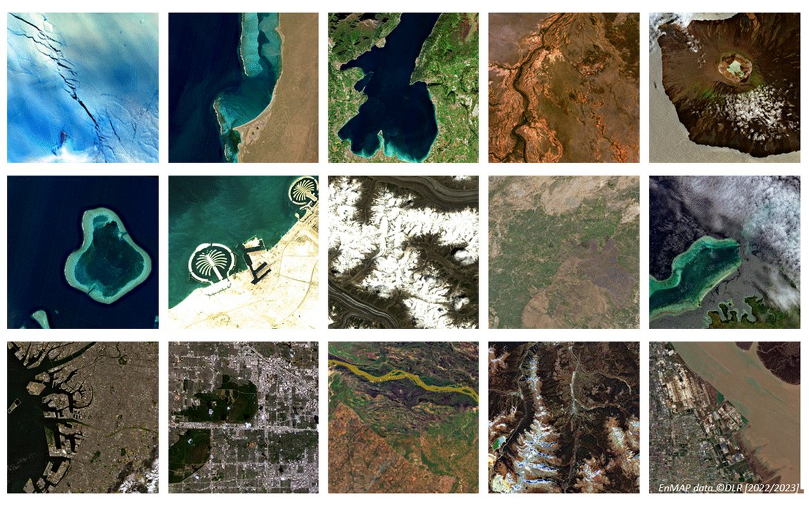
For one year now, the environmental satellite has been orbiting the Earth – delivering impressive and high-quality hyperspectral images and data on the condition of vegetation, soils and waters. Its user community is growing steadily.
It was an exciting year for the EnMAP mission and the entire EnMAP team: Exactly one year ago, on April 1st 2022, EnMAP was successfully launched into space onboard a SpaceX Falcon 9 rocket from Cape Canaveral in Florida, while the first image was recorded over the Istanbul region only three weeks later on 27 April 2022, already demonstrating the high data quality. After the successful completion of the commissioning phase, the mission started in its operational phase on 2 November 2022. Since then EnMAP data has been freely available to users worldwide though the EnMAP user and data access portal. A total of 17,500 image tiles of 30 km x 30 km have since been recorded.
The EnMAP-Mission
EnMAP stands for “Environmental Mapping and Analysis Program”. The hyperspectral mission is under the scientific direction of the GFZ German Research Centre for Geosciences. Over the next few years, it will acquire images of the Earth's surface in around 250 colours (“spectral bands”) and thus provide information on mineral resources as well as on the condition of vegetation, soils and waters more precisely than ever before.
Steadily growing user community
Due to limited data capacity, the satellite does not record data continuously, but on request over regions of interest. For that, researchers from all over the world can submit short data proposals – according to their scientific questions and observation sites of interest. The interest of the community in submitting proposals for future observations and in ordering images from the growing data archive is continuously increasing. As of end of March 2023, 795 registered users from 69 different countries have registered in the portal. The main application fields of the already more than 200 data proposals are vegetation, geology/soils and water. The global distribution of the requested images shows that especially observations over Europe are of great interest.
The scientific management of the mission at the GFZ: Continuous further development of data products and fields of application
During the operational phase of the mission, GFZ is responsible for the scientific mission support along with the EnMAP Science Advisory Group, comprising the evaluation of data proposals, the definition of the background mission sites used whenever the satellite has free capacities, as well as the external validation of the product quality. Furthermore, the team is responsible for the development of analysis algorithms, the demonstration of the data potential in core scientific application fields such as mapping of minerals, soil and crop, and water quality. Currently, first projects are running. Another focus will be to explore potential new application fields.
The EnMAP-team at the GFZ is also responsible for providing information, training and networking opportunities for the user community. Several events such as the EnMAP workshop in September 2022 and the EnMAP graduate school course in March 2023 were held at the GFZ throughout the year to present the mission, the scientific potential and the practical data access and analysis to GFZ scientists.
Résumé and outlook by Sabine Chabrillat, Scientific Principal Investigator of the mission
“We are pleased about the steadily growing user community of the EnMAP data and the broad interest in the scientific community. The first scientific results are impressive and extremely promising, showing the excellent quality of the data. Let's look forward to many more discoveries in several key geo and bio fields all over the Earth with our spectral magnifier in space in the coming years”, says Sabine Chabrillat, Scientific Principal Investigator of the mission, Group Leader in GFZ-section 1.4 Remote Sensing and Geoinformatics and Professor for Digital Soil Mapping at Leibniz Universität Hannover.
Background of the EnMAP mission
The EnMAP mission is under the scientific management of the German Research Centre for Geosciences (GFZ) in Potsdam. The mission's scientific programme is being developed together with the international EnMAP Science Advisory Group. It is supported by the EnMAP Project PI (DLR Space Agency/BMWK) lead by GFZ with the German partners Alfred Wegener Institute in Bremerhaven, Ludwig-Maximilians University Munich, Humboldt-Universität zu Berlin and University of Greifswald.
The EnMAP environmental mission is led by the German Space Agency at the German Aerospace Center (DLR) on behalf of the Federal Ministry of Economic Affairs and Climate Action (BMWK). The development and construction of the satellite and the hyperspectral instrument were in the hands of OHB-System AG. The total cost is around 300 million euros.
Further information about the EnMAP satellite, the mission and training programs are available here:
Environmental Mapping and Analysis Program: www.enmap.org
Users can learn how to use the new data in the online training programmeHYPERedu.
The EnMAP-Boxprovides software for analysing the data.


![[Translate to English:] Hörsaal](/fileadmin/_processed_/e/6/csm_H%C3%B6rsal_f1d7c412b9.webp "[Translate to English:]")


