

The construction of dams has continuously accompanied the history of mankind. Dams protect against flooding and ensure the continuous navigability of rivers. They also serve as water reservoirs for agriculture and drinking water supplies. Above all, however, man uses them to harness the energy of water to generate electricity.
The first intensive construction phase for large dams began as early as the 1930s and continued until the 1950s. An emblematic structure for this first phase is the famous Hoover Dam between the US states of Nevada and Arizona. A second peak phase of construction occurred in the 1970s. At that time, the oil crisis led to the increasing use of hydropower as a profitable alternative. Today, it is estimated that there are between 45,000 and 60,000 large dams worldwide. The number of smaller dams is in the hundreds of thousands. A reliable estimate of the number of large dams is provided by the Global Reservoir and Dam Database (GranD).
But many of these dams are getting old. They are dilapidated and in poor structural condition. Although they are mighty structures made of concrete and steel, they have a limited life cycle. There are many reasons for the poor condition of many large dams: poor maintenance, design flaws, problems with the construction materials used, erosion.
In many small countries and emerging economies, energy generation from hydropower is still of great importance today. This is true not only for water-rich countries, but also arid regions. One example is the countries of Central Asia, which have a continental climate. Many plants there were already built in Soviet times. Their building fabric is also no longer the best. Another problem is that they are located in areas that are threatened by frequent earthquakes. If dams are dilapidated, the consequences can be dramatic, because of the enormous volume of dammed water. In the event of a breach, a tidal wave could roll downstream and destroy entire settlements.
One country where the problem is particularly prevalent is the Kyrgyz Republic, located between China and Kazakhstan. "Kyrgyzstan is one of the countries most vulnerable to earthquakes," says Dr. Marco Pilz. He is an expert on seismic hazards at the German Research Centre for Geosciences in Potsdam (GFZ) and heads the MI-DAM project funded by the German Federal Ministry of Education and Research (BMBF). The earthquake expert knows: Deep beneath Central Asia, the continents are colliding and the Indian Earth Plate is pressing against the Eurasian Plate. These powerful tectonic processes have given rise to the Himalayas and the Pamir Mountains.
Due to the tensions in the rock, the earth trembles again and again in Kyrgyzstan. The last severe earthquake there occurred in 1992 (Ms = 7.3). And even after that, there have been and still are regular small and medium quakes. The old structure of the dams and the constant danger of tremors or landslides are an increasingly serious problem for the country.
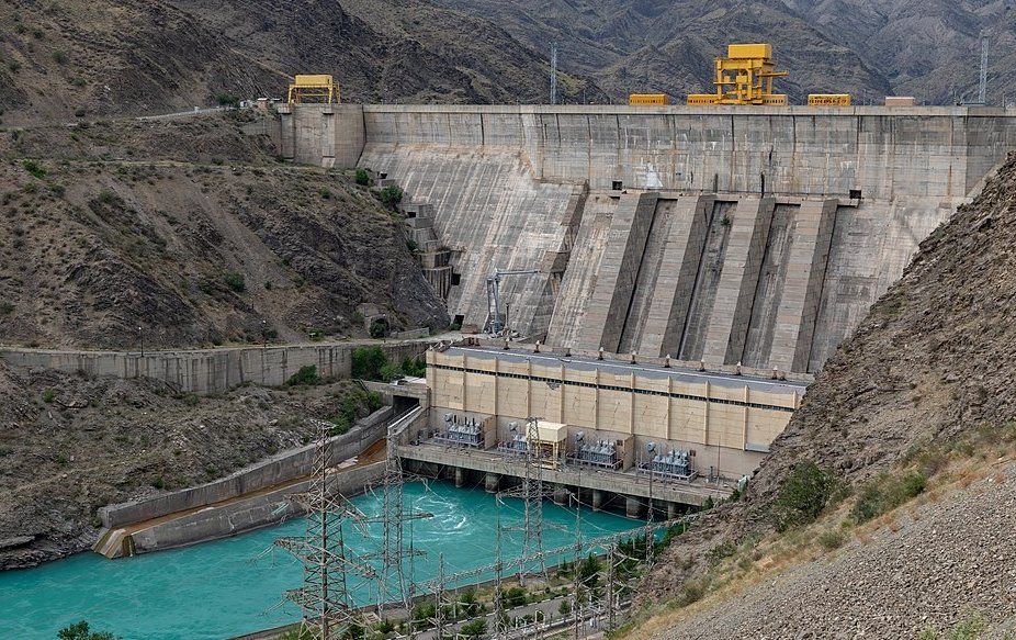
This is why a team of Kyrgyz and German earthquake specialists do their scientific work there. As part of the MI-DAM joint project, the research team, led by the GFZ German Research Centre for Geosciences, has developed a new type of real-time system that monitors dams and can even provide damage forecasts. The system was installed as an example at the Kurpsai Dam in central Kyrgyzstan - an ideal location with steep slopes and regular seismic activity. Kyrgyzstan meets most of its energy needs from hydropower plants - six turbines were built on the Daryn River, and six on the Toktogul reservoir on the border with Uzbekistan. "Kurpsai is the second largest dam in Kyrgyzstan and easily accessible," says Pilz, explaining the selection of the study site. For other dams, it would have been more difficult to obtain an access permit.
Real-time monitoring at the Kurpsai dam
The system developed by the bilateral research team is designed to monitor vibrations, ground movements and long-term structural deformations of the structures. It consists of seismic, fiber-optic and GPS sensors that constantly collect data on the condition of the infrastructure and surrounding slopes and the real-time data is sent to all the research institutes involved. There, the data flows into computer models, which in turn enable damage forecasts – the most important "product" of the research project. The forecasts enable managers to take concrete measures – up to and including the evacuation of settlements or industrial plants. The forecasts are made visible by means of a traffic light system. Green means that the vibration has had no effect on the dam. Yellow, on the other hand, means that an inspection is necessary. Red means that major damage is to be expected and intervention by operators and authorities is required. /// The system for real-time processing of the damage status was continuously improved during the project. Already half a year after the start in autumn 2017, a first version was installed, which has been continuously further refined during the course of our project. In conjunction with long-term measurements at the dam and the steep mountain slopes around the reservoir, so-called fragility curves can be calculated, which describe the occurrence of possible damage for individual infrastructure objects, for example, due to a strong earthquake.
In addition to damage to the structure, rockfalls and landslides are one of the biggest problems for hydropower plants in these mountainous regions, according to GFZ researcher Pilz. The consequences of a landslide above the dam wall, when entire mountain flanks break off and millions of cubic meters of rock fall into the dammed lake, are shown by the Vajont disaster in 1963 in Friuli, Italy. The gigantic wave triggered by the landslide caused one-sixth of the dam's volume to spill over the top of the dam. A community was completely destroyed, 1800 people died. Scientists had later calculated: The impact of the rock masses released an energy equivalent to that of three Hiroshima bombs.
Wide range of applications beyond dams The use of the new multiparameter sensors used in the MI-DAM project – along with the software, the heart of the new early warning system – is not limited to dams. Such monitoring systems can also be used in other important utilities, which are part of the so-called critical infrastructure, as well as in earthquake-prone buildings. In the Kyrgyz capital of Bishkek, similar sensors are currently being tested in large apartment blocks, university buildings and a ministry, among other places.
Another task still lies ahead for the project: it’s the training of local officials/stakeholders. Here, the Kyrgyz scientists currently involved in the project will play a key role and they also continue to provide data analysis in cooperation with the German partners. Ultimately, the monitoring system will only function well if long-term maintenance and care are ensured through local know-how.
Text: Oliver Jorzik, ESKP und Henning Kraudzun, Projekträger Jülich
The detailed report "Early Warning Systems for Dams at Risk" has been published on the Helmholtz Knowledge Platform Earth and Environment ESKP, coordinated by GFZ. Link
Scientific Contact:
Dr. Marco Pilz
Scientist
Seismic Hazard and Risk Dynamics
Helmholtzstraße 6/7
14467 Potsdam
phone: +49-331-288-28661
e-mail: marco.pilz@gfz-potsdam.de
Media contact:
Josef Zens
Head of Public and Media Relations
Helmholtz Centre Potsdam
German Research Centre for Geosciences GFZ
Telegrafenberg
14473 Potsdam
phone: +49-331-288-1040
e-mail: josef.zens@gfz-potsdam.de


![[Translate to English:] Hörsaal](/fileadmin/_processed_/e/6/csm_H%C3%B6rsal_f1d7c412b9.webp "[Translate to English:]")


