


Summary
The last five years in Germany were characterised by massive summer droughts. A great deal of water was lost. But the exact extent of the losses and whether a trend for the future can be derived from them are still unanswered questions. A team from the German Research Centre for Geosciences (GFZ), together with researchers from the University of Bonn and the Jülich Research Centre, has now examined the years from 2002 to 2022 in more detail. Their conclusion: on average, Germany lost 760 million tonnes (0.76 cubic kilometres) of water every year – whether through decreasing soil moisture, dwindling groundwater, melted glaciers or lowered water levels. The study is primarily based on data from the GRACE (2002 to end of mission 2017) and GRACE-Follow On (active since 2018) satellite missions. What is special about this study is that the researchers compared four different evaluation methods of the satellite data and thus arrived at a significantly lower water loss than other evaluations, which were based on only one method. The total water storage (Terrestrial Water Storage, TWS) has thus decreased by a total of 15.2 cubic kilometres over the two decades. By comparison, the water consumption of all sectors – industry, agriculture, private households – in Germany is around 20 cubic kilometres per year. However, the researchers write in the April issue of the journal “Hydrologie & Wasserbewirtschaftung (HyWa)” that the time period is too short and too marked by various extremes to be able to reliably estimate a trend.
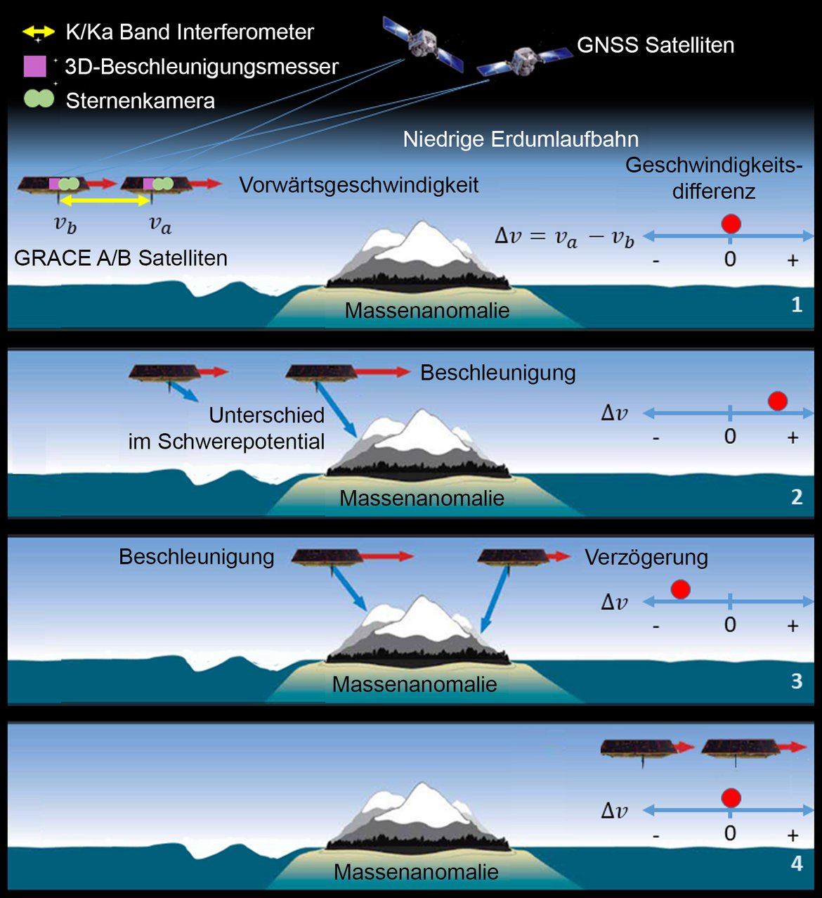
Background: Determining the Earth’s gravity field and water mass changes from satellite data
The satellite missions GRACE (2002 until mission end 2017) and GRACE-Follow On (active since 2018) are unique. The satellite tandems measure the Earth's gravitational force, the so-called gravity field, and its changes globally on a monthly basis. From this gravity field data, mass shifts can be detected, which in turn allow conclusions to be drawn about changes in the water cycle, for example the melting of glaciers or the emptying of groundwater reservoirs. For the first time, for example, it has been possible to quantify the loss of ice mass in Greenland and the Antarctic. The great advantage of this type of measurement: it also records aquifers that are hidden deep below the Earth's surface. The disadvantage: the spatial resolution of the gravity field data is comparatively coarse: around 300 by 300 kilometres. Reliable statements can therefore only be made for areas of around 100,000 square kilometres, which is roughly the size of the former GDR.
New analysis of different data series for Germany (2002-2022)
A team of researchers led by Andreas Güntner of the GFZ German Research Centre for Geosciences has now published for the first time a detailed overview of the changes in total water storage measured by satellites over the last twenty years for Germany. Colleagues from several GFZ sections as well as researchers from the Institute of Geodesy and Geoinformation at the University of Bonn and from the Research Centre Jülich were involved.
Differences in the evaluation of the data
For the evaluation of the data – both with regard to the determination of the gravitational field and, derived from this, the determination of the stored water masses – a whole series of interfering effects must be factored out. For example, the data areas measuring 300 by 300 kilometres are naturally not sharply delineated, because the influence of gravity on the satellites cannot be traced back to clearly defined segments of the Earth as is the case with a satellite image. This can be seen, for example, in the fact that the gravitational field effect of melting Alpine glaciers also overlays the measurements for the water resources in the Alpine foothills (the effect is called “leakage”): When the glacier masses recede, it looks to the satellites as if more distant water masses have also disappeared. In addition, the Earth's gravitational field also changes without any acute change in water masses. One such effect, for example, is that in some regions the Earth's crust is still rising today after the disappearance of the ice-age glaciers.
Depending on the processing methods and correcting factors, slightly different values for the gravity field and its variations result. The researchers used four data series for their study: the GFZ's own data series, a combination solution calculated from several data series from the University of Bern (called COST-G), one from the Universities of Graz and Bonn (ITSG/UB), and one from NASA's Jet Propulsion Laboratory (JPL Mascons). In addition, they used precipitation data and computer models from FZ Jülich, which simulated the change in total water storage.
Comparison of results
Over large parts of the observation period, especially in the years between 2004 and 2015, the results of all four data sets for the gravity field changes agree well. There were differences mainly at the beginning and end of the time series. The year 2002 was marked by extreme precipitation, especially in southern and eastern Germany. The devastating floods on the Danube and the Elbe occurred in August 2002. And at the end of the study period are the dry years since 2018. In both extreme cases, the NASA-JPL data series in particular showed larger swings up and down. The seasonal differences between the maximum water storage in winter and the minimum in summer are also strongest in the NASA-JPL series.
Caution advised in data interpretation
The researchers therefore urge caution in interpreting evaluations based on only one data series, and point out in particular the special sensitivity to flood or drought extremes in the NASA-JPL-Mascons series. They suspect the cause in different processing procedures and in the correction for the “leakage” effect.
Discussion of previous publication: 0.76 versus 2.5 cubic kilometres average water loss per year in Germany
However, it was precisely this data series and conclusions drawn from it that led to a major media echo last year: Germany's total water reservoir was losing almost 2.5 cubic kilometres of water per year, it had been said, with the southwest being particularly affected. The comparison with other evaluation methods now shows: it is probably only 0.76 cubic kilometres, i.e. just under a third of the loss quantified by the JPL Mascons series. And especially near the Alps, the gravity field effect of melting glaciers (leakage) must also be taken into account.
Conclusion and need to extend the data series
Despite the lower values, the lead author of the study, Andreas Güntner, points out: “The observations from all data sets show that a year with higher precipitation like 2021 is not sufficient to make up for the water storage deficits that have accumulated over the longer period.”
The researchers also advise caution when it comes to forecasts. Co-author Helena Gerdener from the University of Bonn warns: “Since there have been some striking extremes in the twenty years of data collection so far, it is difficult to make a statement about a long-term trend.”
The continuity of the measurement series is all the more important, the researchers write. A continuation of the GRACE and GRACE-FO missions is already being planned and is scheduled to launch into space in 2028.
Original publication:
Güntner, A., Gerdener, H., Boergens, E., Kusche, J., Kollet, S., Dobslaw, H., Hartick, C., Sharifi, E., Flechtner, F. (2023): Changes in water storage in Germany since 2002 from satellite gravimetry observations. Hydrology & Water Management, 67, (2), 74-89.
DOI: 10.5675/HyWa_2023.2_1


![[Translate to English:] Hörsaal](/fileadmin/_processed_/e/6/csm_H%C3%B6rsal_f1d7c412b9.webp "[Translate to English:]")


