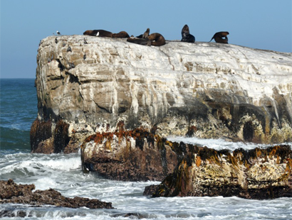
The island Isla Santa María in the south of central Chile is the document of a complete seismic cycle
22.06.2015: Charles Darwin and his captain Robert Fitzroy witnessed the great earthquake of 1835 in south central Chile. The „Beagle“-Captain's precise measurements showed an uplift of the island Isla Santa María of 2 to 3 meters after the earthquake. What Darwin and Fitzroy couldn’t know was the fact that 175 years later nearly at the same position such a strong earthquake would recur.
At the South American west coastline the Pacific Ocean floor moves under the South American continent. Resulting that through an in- and decrease of tension the Earth’s crust along the whole continent from Tierra del Fuego to Peru broke alongside the entire distance in series of earthquakes within one and a half century. The earthquake of 1835 was the beginning of such a seismic cycle in this area.
After examining the results of the Maule earthquake in 2010 a team of geologists from Germany, Chile and the US for the first time were able to measure and simulate a complete seismic cycle at its vertical movement of the Earth’s crust at this place.
In the current online-edition of the scientific journal Nature Geoscience they report about the earthquakes: After the earthquake of 1835 with a magnitude of about 8,5 Isla Santa María was uplifted up to 3 m, subsided again about 1,5 m in the following 175 years, and uplifted anew 1,5 to 2 m caused by the Maule earthquake with a moment magnitude scale of 8,8.
The Maule earthquake belongs to the great earthquakes, which was fully recorded and therefore well documented by a modern network of space-geodetical and geophysical measuring systems on the ground. More difficult was the reconstruction of the processes in 1835. But nautical charts from 1804 before the earthquake, from 1835 and 1886 as well as the precise documentation of captain Fitzroy allow in combination with present-day methods a sufficient accurate determination of the vertical movement of the earth’s crust along a complete seismic cycle.
At the beginning of such a cycle energy is stored by elastic deformation of the earth’s crust, then released at the time of the earthquake. “But interestingly, our observations hint at a variable subsidence rate during the seismic cycle” explains Marcos Moreno from GFZ German Research Centre for Geosciences, one of the co-authors. “Between great earthquakes the plates beneath Isla Santa María are large locked, dragging the edge of the South American plate, and the island upon it, downward and eastward. During the earthquakes, motion is suddenly reversed and the edge of the South America Plate and island are thrust upward and to the west.” This complex movement pattern could be perfectly confirmed by a numerical model. In total, over time arises a permanent vertical uplift of 10 to 20% of the complete uplift.
Records of earthquakes show that there are no periodically sequence repetition times or consistent repeating magnitudes of earthquakes. An important instrument for a better estimation of risks caused by earthquakes are the compilation and measurement of earth’s crust deformation through an entire seismic cycle.
Article: Wesson, R. L., Melnick, D., Cisternas, M., Moreno, M. & Ely, L. 2015: “Vertical deformation through a complete seismic cycle at Isla Santa María, Chile”, Nature Geoscience, Advance Online Publication, 22.06.2015,http://dx.doi.org/10/1038/ngeo2468 (2015). DOI: 10.1038/NGEO2468
A further picture (photo : M. Moreno, GFZ) can be found here>>


![[Translate to English:] Torsten Sachs in front of a climate station on a field](/fileadmin/_processed_/3/9/csm__TorstenSachs_bearbeitet_GS_4a1365ef84.jpeg)
![[Translate to English:] left image flood at the Ahrtal: image from above, several houses are flooded; left image:: Heidi Kreibich;](/fileadmin/_processed_/4/4/csm_Bild2_9af0130e9f.png)
![[Translate to English:] Start der Vega Rakete](/fileadmin/_processed_/6/4/csm_20231201-kachel_Vega-VV23-launch_ESA-CNES-Arianespace_706716b68c.jpeg)


![[Translate to English:] Poster exhibition at the Brandenburg Hydrogen Day at the GFZ, some participants in the foreground](/fileadmin/_processed_/6/5/csm_Erster_Brandenburgischer_Wasserstofftag_GFZ_402fcec95e.jpeg)
![[Translate to English:] Group picture of the participants](/fileadmin/_processed_/9/4/csm_20231108_CAWa-Workshop-Tashkent_Gruppenbild_99ea779d8a.jpeg)
![[Translate to English:] [Translate to English:] Hörsaal](/fileadmin/_processed_/e/6/csm_H%C3%B6rsal_e21ac645fb.jpeg)
![[Translate to English:] The Delegations in the Historic Library on the Telegrafenberg. In the back there are from left to right, the Dutch Ambassador for Germany, Ronald van Roeden, the Dutch Minister for Education, Culture and Science, Robbert Dijkgraaf and the scientific director of the GFZ, Susanne Buiter.](/fileadmin/_processed_/d/b/csm_Kachel-2_9eba4b4212.jpeg)
