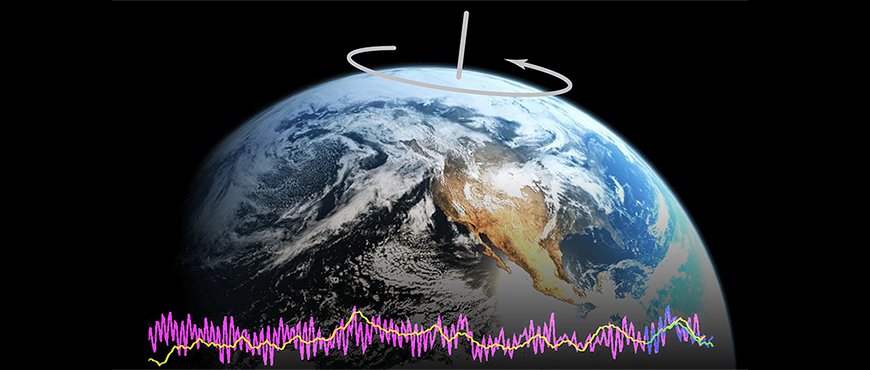
Every day, our planet rotates once around its own axis. Since the Earth is not a homogenously rigid sphere, its rotational speed is not uniform. Responsible are in particular the large-scale wind and ocean current systems, but also water mass redistribution at the continents via the water cycle. As a result, the pointing of the Earth's rotational axis relative to the celestial sphere changes slightly but detectably in time. In the scientific journal Advances in Space Research the GFZ scientists Henryk Dobslaw and Robert Dill, section Earth System Modelling, describe how short-term predictions of Earth orientation changes are improved by utilizing present-day numerical models of geophysical fluid dynamics.
Precise information about the orientation of the Earth in space is needed for several scientific applications and in everyday life. Examples are the communication with autonomous space crafts, the location and tracking of objects in space, or high-precision positioning at the Earth's surface by means of global navigation satellite systems. Most of those applications do not only need data describing the current status, but additionally require information about upcoming changes in the Earth orientation parameters. Such a view into the future is provided by the International Earth Rotation and Reference Systems Service (IERS), which regularly publishes forecasts on Earth’s orientation changes for the next 90 days.
Weather forecasts help predicting polar motion
The IERS relies on observations from Very Long Baseline Interferometry. Harald Schuh, head of the GFZ Department Geodesy: “This technique provides important information about the orientation of the Earth in space. With about fifty radio telescopes distributed over the whole Earth, we are able to determine the Earth's orientation in relation to quasars or radio galaxies so far away from Earth that they virtually do not change their position at all.”
VLBI data are processed by the GFZ for various scientific applications in Geodesy, Geophysics, and Astronomy. Also laser ranging observations to Earth orbiting satellites are acquired, and data from global navigation satellite systems like GPS or Galileo are taken into account. All those data are used by GFZ scientists to establish a global terrestrial reference frame, which allows for the determination of the Earth's orientation in space. Based on those results, the IERS calculates changes in the orientation of the rotational axis and its associated predictions of future changes.
Within their study, Dobslaw and Dill demonstrate that they are able to improve those IERS predictions by about 40 percent. Henryk Dobslaw: „We use current numerical weather prediction data from the European Center for Medium-Range Weather Forecasts and the German Meteorological Service as well as models of water cycle and ocean dynamics and integrate them into the polar motion forecasts.”
Therefore the scientists rely on an ocean circulation model maintained at the GFZ and combine it with hydrological modeling data and weather forecasts. Thus, they are able to assess the impact of mass movements on the Earth’s surface on changes of the Earth’s rotational axis. Maik Thomas, head of GFZ Section Earth System Modelling: “Only the joint consideration of the dynamics in the atmosphere, oceans, and the water cycle can explain for the observed changes in Earth’s orientation. Knowing this already for quite some time, we were eventually able to predict future changes in polar motion.” Transferring this knowledge into an actual improvement of routine forecasts was now achieved for the first time in the new study. (ak)
Original study: Dobslaw, H., Dill, R., 2018. Predicting orientation changes from global forecasts of atmosphere-hydrosphere dynamics. Advances in Space Research 61, 1047-1054. DOI: https://doi.org/10.1016/j.asr.2017.11.044




![[Translate to English:] Torsten Sachs in front of a climate station on a field](/fileadmin/_processed_/3/9/csm__TorstenSachs_bearbeitet_GS_4a1365ef84.jpeg)
![[Translate to English:] left image flood at the Ahrtal: image from above, several houses are flooded; left image:: Heidi Kreibich;](/fileadmin/_processed_/4/4/csm_Bild2_9af0130e9f.png)
![[Translate to English:] Start der Vega Rakete](/fileadmin/_processed_/6/4/csm_20231201-kachel_Vega-VV23-launch_ESA-CNES-Arianespace_706716b68c.jpeg)




![[Translate to English:] Poster exhibition at the Brandenburg Hydrogen Day at the GFZ, some participants in the foreground](/fileadmin/_processed_/6/5/csm_Erster_Brandenburgischer_Wasserstofftag_GFZ_402fcec95e.jpeg)
![[Translate to English:] Group picture of the participants](/fileadmin/_processed_/9/4/csm_20231108_CAWa-Workshop-Tashkent_Gruppenbild_99ea779d8a.jpeg)
![[Translate to English:] [Translate to English:] Hörsaal](/fileadmin/_processed_/e/6/csm_H%C3%B6rsal_e21ac645fb.jpeg)
![[Translate to English:] The Delegations in the Historic Library on the Telegrafenberg. In the back there are from left to right, the Dutch Ambassador for Germany, Ronald van Roeden, the Dutch Minister for Education, Culture and Science, Robbert Dijkgraaf and the scientific director of the GFZ, Susanne Buiter.](/fileadmin/_processed_/d/b/csm_Kachel-2_9eba4b4212.jpeg)
