

Indien slides under Tibet, but how?
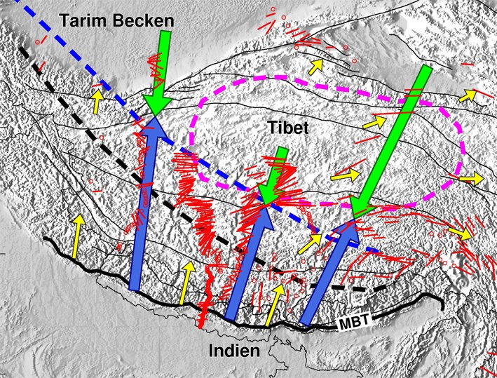
17.09.2010 | Potsdam: During the collision of India with the Eurasian continent, the Indian plate is pushed about 500 kilometers under Tibet, reaching a depth of 250 kilometers. The result of this largest collision in the world is the world’s highest mountain range, but the tsunami in the Indian Ocean from 2004 was also created by earthquakes generated by this collision. The clash of the two continents is very complex, the Indian plate, for example, is compressed where it collides with the very rigid plate of the Tarim Basin at the north-western edge of Tibet. On the eastern edge of Tibet, the Wenchuan earthquake in May 2008 claimed over 70,000 deaths. Scientists at the GFZ German Research Center for Geosciences report in the latest issue of the scientific journal "Science" (vol. 329, Sept. 17, 2010) on the results of a new seismic method which was used to investigate the collision process.
In international cooperation, it was possible to follow the route of the approximately 100 kilometers thick Indian continental plate beneath Tibet. To achieve this, a series of large seismic experiments were carried out in Tibet, during which the naturally occuring earthquakes were recorded. By evaluating weak waves that were scattered at the lower edge of the continental plate, this edge was made visible in detail. The boundary between the rigid lithosphere and the softer asthenosphere proved to be much more pronounced than was previously believed.
The entire Indian sub-continent moves continuously north over millions of years and has moved 2 meters below Tibet in the last 50 years alone. The Himalayas and the highlands of Tibet, the highest and largest plateau in the world, were formed this way. But the recurring catastrophic earthquakes in China are also caused by this collision of two continents. For a better understanding of the processes involved in the collision of the two plates, it is hoped to ultimately reduce the earthquake risk to millions of people across the entire collision zone.


![[Translate to English:] Hörsaal](/fileadmin/_processed_/e/6/csm_H%C3%B6rsal_f1d7c412b9.webp "[Translate to English:]")


