

Landslides and rockfalls are a significant hazard in mountain regions. A demonstration of the destructiveness of these natural processes was the catastrophe in the Colombian town of Mocoa at the end of March 2017. A large number of landslides in the back country led to a torrent of debris and mud that flooded large parts of the town and took the life of more than 300 people. To prevent this kind of risk it is crucial to better understand the underlying processes. In a current project in Switzerland a team of scientists led by Michael Dietze from the GFZ section Geomorphology investigates the timings and links to different triggers of rockfalls. First results are now published in the journal Earth Surface Dynamics.
Between autumn 2014 and spring 2015 the scientists investigated 49 rockfalls on an area of about two square kilometres in the Lauterbrunnen Valleyl in Bernese Oberland in the Swiss Alps. By using high temporal resolution seismic measurements they were able to determine the moment of detachment of a rockfall to the second. Knowing the precise timing, they could also investigate the triggers causing the movements of rocks on a slope.
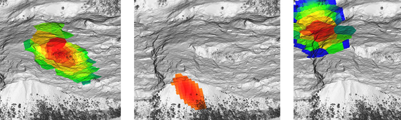
Monitoring and classification of rockfalls
Rockfalls are a geomorphic process, a process that acts at and sculpts the Earth’s surface. Michael Dietze, first-author of the study says: „Rockfalls usuallybegin abruptly when rocks have lost their last contact with the cliff, followed by free fall. This is why optical monitoring approaches are complicated and temporally imprecise. Thus, for an early warning and trigger investigation optical methods alone are of limited capabilities“. This is why the scientists started their “eavesdropping” on the Earth’s surface with seismic instruments. They installed a network of six broadband seismometers at distances of about one kilometre to each other. With these instruments they were able to detect small ground motions with higtemporal resolution. This large-scale monitoring of the subsurface provided the scientists with precise information on detachment time, point of impact, and dimension of a rockfall.
A correlation of the data with information on earthquakes, temperature, and weather conditions allowed for identification of potential triggers. The scientists classified the recorded rockfalls into three types: 5 out of 49 recorded events were linked to freeze-thaw cycles, 19 to precipitation events, and 17 to daily variations in temperature – they occurred during the coldest time of a day or during phases with rapid changes in temperature. Only 7 events could not be classified.
The investigations of the working group contribute to a better understanding of rockfall triggers and triggers of other mass movements at the Earth’s surface. In the future, seismic networks can improve early warning in alpine regions and thereby protect human lives. The required infrastructure and software is currently being developed in the GFZ section Geomorphology.
Closer collaboration with Columbia for future disaster prevention
On 3 April the Columbian Ambassador María Lorena Gutiérrez Botero came to visit the GFZ. Besides considering further collaboration between Columbia and the GFZ in general, in the light of recent events options on research-cooperation in the field of early warning for rockfalls and hillslides were discussed. Since the trigger mechanisms are rather variable, research at the GFZ in this field is interdisciplinary.
Sigrid Roessner from the GFZ section Remote Sensing reported on the analysis of natural hazards using optical and radar techniques. One focus of her research is the development of remote sensing methods for longer-term monitoring of natural hazards also including so-called ‘rapid mapping’ that can be used for instant impact assessment. Niels Hovius, Head of the GFZ section Geomorphology, emphasised the importance of investigating the interaction and combination of different processes, to be able to better understand events like the one in Columbia. Besides projects in the Swiss Alps, his section also works on landslide-processes in Nepal and at German cliff coasts. Thomas Walter from the section Physics of Earthquakes and Volcanoes presented the possibility of monitoring changes on the Earth’s surface via satellite systems and other geophysical measurements that are developed at the GFZ for process analysis of volcanoes.
Following the discussions Reinhard Hüttl, GFZ Scientific Executive Director, visited the Columbian Geological Service in Bogota to meet with the director Oscar Paredes Zapata and discuss further cooperation of the two institutes. A next step is the planning of a workshop with colleagues from Columbia in Bogota. Ludwig Stroink, Head of the International Office at the GFZ „We would especially like to more closely collaborate in the field of assessing geohazards. Besides hillslides these are for example earthquakes and volvcanoes“. The workshop aims at sounding out these collaborations and at concretising further research activities. (ak)
Original study: Dietze, M., Turowski, J.M., Cook, K., Hovius, N., 2017. Spatiotemporal patterns and triggers of seismically detected rockfalls. Earth Surface Dynamics. DOI: 10.5194/esurf-5-757-2017


![[Translate to English:] Hörsaal](/fileadmin/_processed_/e/6/csm_H%C3%B6rsal_f1d7c412b9.webp "[Translate to English:]")


