

Precise determination of distance with TOR
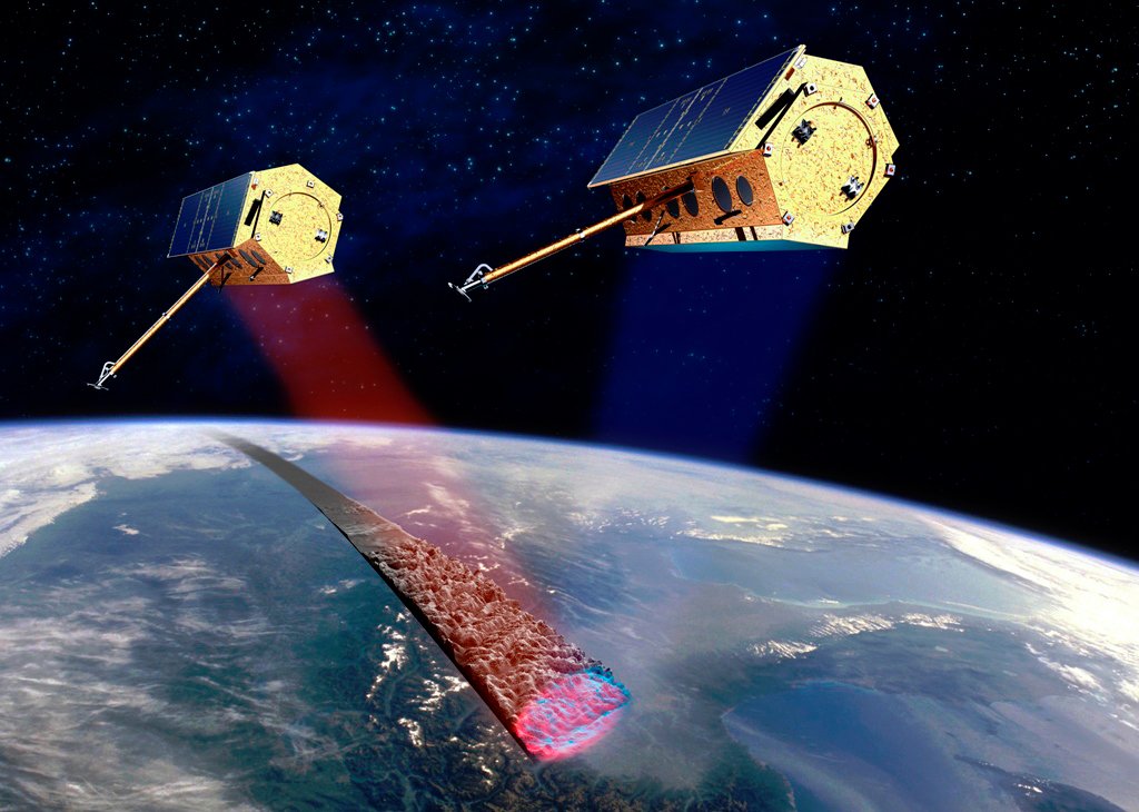
22.06.2010 | Potsdam: From the spaceport Baikonur (Kazakhstan) the German Earth Observation Satellite, TanDEM-X, was brought into orbit at a height of 514 km on 21 June at 04:14:02 MESZ. On board: the navigational instrument TOR, developed by scientists at the GFZ German Research Centre for Geosciences in Potsdam. TanDEM-X will record data on the elevation of the Earth's surface with a dissolution unattained to date – thus, the TOR instrument is the technical basis, without which the mission would not be possible.
In order to achieve the aspired accuracy, the two satellites, TerraSAR-X and TanDEM-X, flying close to each other independently scan the Earth's surface using radar techniques. If the distance between the two satellites is known, the elevation of the Earth's surface can be determined from this triangular constellation. Therefore, the determination of the distance between the satellites is of crucial importance. And the TOR instrument serves this purpose.
The key principal in the development of the elevation models (Digital Elevation Models, DEM) with the desired height accuracy is the constant and highly precise determination of this distance, the baseline. The general rule of thumb is that a one millimetre error in the baseline results in a final error in the meter bracket. The TOR instrument flies on board both satellites and measures their distance with high accuracy. The GFZ, however, measures not only the baseline, but also uses the TOR instrument for the collection of globally distributed vertical profiles of atmospheric variables such as temperature and water vapour content and for the supervision of the condition of the ionosphere.
In addition, the information on the orbit derived from TOR, will, together with SAR data contribute to solving geoscientific problems. This main measuring procedure of the TerraSAR-X and TanDEM-X satellites is used for ecological, geophysical and hydrological investigations. In particular land slides, ground subsidence in residential areas, ice surface and glacier decline, surface water and earthquake-relevant seismic deformation can be examined.
The TOR instrument comprises a double-channel GPS receiver and a laser reflector for the orbit measurement by means of Satellite Laser Ranging (SLR). The GPS receiver was developed by the US Jet Propulsion Laboratory, while the SLT reflector was an internal development of the GFZ and is already on board the geo-research satellites CHAMP and GRACE. The TOR package is in operation on 5 satellites: its GPS receiver delivers continuous measurements every 5 seconds independent of weather conditions.
The large quantity of GPS data and their high accuracy allows for the continuous and millimetre-exact calculation of the baseline and the centimetre-exact positioning of the satellites in close scanning. The laser impulses of the 25 world-wide distributed ground-stations are used for the calibration of the GPS measurements, one of these stations is operated by the GFZ in Potsdam.


![[Translate to English:] Hörsaal](/fileadmin/_processed_/e/6/csm_H%C3%B6rsal_f1d7c412b9.webp "[Translate to English:]")


