

10 years CHAMP-Mission: Exploration of gravity, magnetic field and atmosphere
15.07.2010 | Potsdam: Today, on the 15th July at 14:32 GMT, the georesearch satellite CHAMP orbits the Earth for the 57217th time, thus heralding its 10th anniversary in service. Exactly one decade ago, the satellite was set into an almost polar orbit at the head of a Russian COSMOS-rocket following a text-book launch from the Plesetsk cosmodrome.
"CHAMP is, without doubt, today regarded as one of the most successful missions to explore the Earth system", says Professor Reinhard Hüttl, Scientific Executive Director of the GFZ German Research Centre for Geosciences. "Our scientists were indeed convinced of the scientific value of this mission 10 years ago. The wealth of data and new insights this mission yielded, however, surprised us all. CHAMP has provided groundbreaking new knowledge in its three mission areas”.
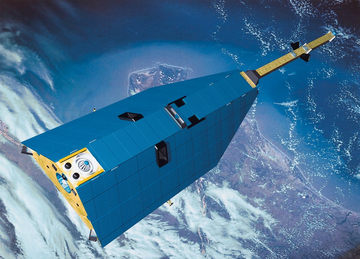
The Federal Ministry for Education and Research initiated this satellite mission in 1995 as a flagship project for the East German space industry, in order to promote the existing know-how in Eastern Germany in this field. The concept CHAMP (Challenging Mini Satellite Payload), proposed by the GFZ, was selected for the realization of this mission. The result was a 522 kg heavy satellite with a total length of 8,33 m, which was used to measure the Earth’s gravity field, the Earth’s magnetic field and to monitor the atmosphere on a global scale.
A better picture of the Earth’s gravity
Like all satellites orbiting close to the Earth, CHAMP does not follow a perfect elliptical trajectory due to the irregular mass distribution on and within the Earth resulting in a varying stronger or weaker pull. The analysis of the trajectory can, therefore, bring insight into the underlying and variable gravitational force exerted by our planet. With CHAMP it was possible, for the first time, to continuously track a satellite flight path via GPS, every second and with centimetre accuracy. Due to the solar radiation and the remaining atmosphere at the orbiting altitude of 460 kilometres, the satellite is slightly decelerated; CHAMP, however, is the first satellite to carry a 3-D accelerometer, which is located inside the satellite and able to measure this deceleration directly and with high accuracy. The position and the orientation of the satellite in space are also monitored using star trackers. This unique and innovative configuration of instruments enabled the CHAMP researchers to determine the gravity field from the trajectory disturbances of a single satellite only - which was never possible before.
As a result, the spatial resolution of the Earth’s gravity field model could be raised from 1500 km to 300 km. The bumps and dents on the corpus of the Earth were recorded more clearly than ever, and the resulting image of Earth’s gravity is now known worldwide as “The Potsdamer Gravity Potato”. The application of these data is very diverse and ranges from geophysics and oceanography to precise satellite navigation.
Another “first” with CHAMP was the verification of temporal and large-scale spatial changes in the gravitational field. This way, the satellite initiated the GRACE (Gravity Recovery and Climate Experiment) mission, which consists of two identical twin satellites with CHAMP-like instruments on board.
CHAMP magnetic field measurements
The multi-talented CHAMP has also provided new insights into the recording of the Earth’s magnetic field. The change of the magnetic field over the last ten years shows, as an important result, the current decrease in the strength of the magnetic field, a trait which is usually very distinctive in the region around the South Atlantic. In this zone of weaker field, a reduction of 12 per cent over the last 30 years was registered. Already now we can observe an accumulation of interferences in satellite operation, due to radiation influences in this area.
The CHAMP mission is making great progress in the surveying of magnetised rocks from the Earth’s crust. It was possible to generate maps of the magnetic signals with a previously unobtainable resolution, showing reservoirs of important minerals and ores. Particularly prominent is the Russian iron ore reservoir in Kursk, but the West African layers containing diamonds are just as conspicuous. Furthermore, it is possible to determine the rate at which the oceans expand in certain regions, and the zones in which the crust dives under the mantle.
A completely new application is the detection of irregularities in the ionosphere. These disturb the reception of GPS signals. Based on the CHAMP data on the magnetic field over the last ten years, a kind of climatology of irregularities was created. A distinct pattern characterizes the distribution of these irregularities, which is highly dependent on the time of year, the time of day, and the latitude and longitude of the position in question. These results are of a great interest due to the increasing importance of GPS applications.
One very surprising result of the CHAMP-Mission is the detection of magnetic signals which are generated by oceanic tides. If a conducting liquid is moved perpendicular to the magnetic field, an electrical field is generated, which forms a magnetic field of its own. At CHAMP’s flight altitude, its value was a mere 1/50.000 of Earth’s main magnetic field.
CHAMP also raises the bar when it comes to magnetic field measurements using satellites: the 2012 ESA mission SWARM consists of three satellites modelled on CHAMP.
GPS-based remote sensing of the atmosphere and ionosphere with CHAMP
CHAMP is the first satellite mission, employing the innovative GPS radio occultation method for continuous and global sounding of the Earth’s atmosphere and ionosphere. If, from the CHAMP perspective, one of the GPS-Satellites goes down behind the Earth, the signals from this satellite disappearing behind the Earth are altered on the satellite’s way through the Earth’s atmosphere. Thus, vertical profiles of atmospheric parameters can be derived, as, e.g., temperature, water vapour content or also electron density in the ionosphere. Due to its polar orbit, CHAMP allows the global determination of these dimensions, which are used in the weather forecast and climate research. It became apparent that already the approximately 160 daily CHAMP measurements have lead to a significant improvement in the global forecasts. In 2006 the CHAMP from GFZ were operationally and continuously used for the first time by the British Met Office to improve global weather forecasts. Other weather centres in Europe, Japan, Canada soon followed suit
The time series of GPS radio occultation measurements, created by CHAMP, is, to date, the only and longest GPS-RO data record available. First climatological investigations with the very exact CHAMP data confirm results obtained with other atmospheric data or climate models. Thus, trend analyses of the temperature at an altitude between 5 km and 25km clearly show a slight warming in the troposphere, while in large parts of the stratosphere a cooling could be observed.
GPS reflectrometry and space weather
Unexpected, but highly welcome was the fact that CHAMP could also register reflected GPS signals from ocean and ice surfaces. These signals contain information on the reflected water and ice surfaces and have a high potential for their remote sensing. In future it is expected that with GPS reflectrometry, for example, wave heights above sea surfaces can be determined, this can be correlated with wind velocity and wind direction.
The continuous application of the GPS method also allowed for the determination of so-called space weather. The ionosphere, as an integral part of the space weather, plays an important role in the telecommunication, satellite navigation and radio radar systems. The systematic monitoring of the space weather contributes to the early recognition of possible dangers and thus the issuing of appropriate forecasts or eventual warnings.
End of a business trip
Ten years ago CHAMP went into orbit at a height of approximately 460 km. Since then it has dropped height continuously. CHAMP owes its long life partly to the fact that cold gas, which serves the positioning control, was used to raise CHAMP to higher altitudes on four occasions. Now, however, CHAMP has reached a height of 265 kilometres, at which point the density of the atmosphere increases towards the earth and decelerates the satellite continuously. Because of this and its aerodynamic form the satellite, thus, repeatedly rears up. Therefore, the controllers in the space control centre turned it backwards for the last months, CHAMP is flying in reverse. But this manoeuvre will also not help in the long run: the satellite CHAMP is expected to finally burn up after an extremely successful mission in September this year.


![[Translate to English:] Hörsaal](/fileadmin/_processed_/e/6/csm_H%C3%B6rsal_f1d7c412b9.webp "[Translate to English:]")


