

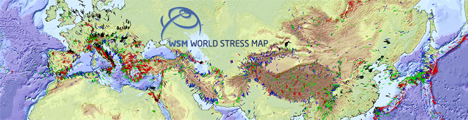
09.12.2016: The international World Stress Map Project (WSM) describes the present-day stress state of the Earth’s crust, displays it in global maps, and investigates sources of stress. On its 30th anniversary the project, coordinated by Oliver Heidbach, GFZ section Seismic Hazard and Stress Field, publishes a new global database.
The database describes the present-day stress state of the Earth’s crust. Compared to the previous version, the number of available data was doubled; national databases of eight more countries are now fully integrated: Australia, China, Great Britain, Canada, New Zealand, Italy, Iceland, and Switzerland. Due to a significant improvement in data density, even local and regional anomalies are now resolved for many areas.
Thus, it is now possible to better understand sources of stress and to address questions related to the local stability of the underground, for example. This also supports the safe usage of the underground, for example in geothermal reservoirs. Via a web interface the data are openly accessible and provided in form of stress maps. The application areas are geo- and engineering disciplines, such as geodynamics, plate tectonics, geo-hazard assessment, reservoir management or tunnelling. The data are also of key importance for the investigation of potential disposal sites for high-level radioactive waste.
Previous work of the WSM focused on data of the orientation of the maximum horizontal stress of the Earth’s crust. Future work will focus on the compilation of data on the magnitude of the stress field. These data will then be used to calibrate geomechanical-numerical models that provide a continuous description of the 3D stress state of the Earth’s crust.
The WSM is a cooperation of geoscientific and engineering research institutions, as well as partners from industry and administration. The project was initiated in 1986 by the International Lithosphere Program (ILP). Between 1995 and 2008 it was led by the Heidelberg Academy of Science and Humanities, and since 2009 the GFZ is coordinator of the project. Since 2012 the project is a member of the International Council for Science World Data System. (ak)


![[Translate to English:] Hörsaal](/fileadmin/_processed_/e/6/csm_H%C3%B6rsal_f1d7c412b9.webp "[Translate to English:]")


