

Deep seismic investigations in the Black Forest (SW Germany)
The European Variscides, extending from the French Central Massif to the East European Platform, originated during the collision between Gondwana and Baltica in the Late Palaeozoic. Due to involvement of various crustal blocks in the orogenesis, the mountain belt is subdivided into distinct zones. The external fold-and-thrust belts of the Rhenohercynian (RH) and Saxothuringian (ST) as well as the predominantly crystalline body of the Moldanubian (MN) dominate the central European segment of the Variscides. Polyphase tectonic deformation, magmatism and metamorphic processes led to a complex interlinking between the units.
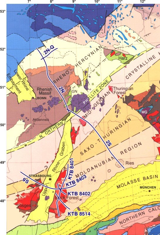
The survey KTB '84 was located in the Black Forest, a crystalline massif at the eastern boundary of the Upper Rhine Graben within the Moldanubian zone. The crystalline basement of the Black Forest consists of high-grade gneisses and migmatites intruded by Variscan granites. It was uplifted during the Tertiary rift movements of the Rhine Graben. The Black Forest area was one of the candidates for the KTB drilling site.
The seismic survey KTB '84 aimed
- to investigate the crustal structure of the Black Forest massif with respect to the role and extent of Variscan thrust and extension tectonics,
- to map the geometry of deep crustal reflection patterns,
- to select a suitable site for the KTB drill hole.
In 1984 the seismic experiments of KTB '84, consisting of lines KTB 8401 - KTB 8403, were performed by the DEKORP Research Group. The network of lines consists of a long, N-S trending profile (KTB 8401) and 2 short cross-lines KTB 8402 and KTB 8403. Profile 8403 is the western prolongation of the Urach profile U 1 and was extended again westwards by line DEKORP 9S in 1988. In 1985 the KTB '84 grid was completed by line KTB 8514 which crosses line 8401 in its southern part (see location map).
The seismic survey consisted of four types of investigation:
- deep reflection profiling
- deep refraction profiling
- expanding-spread profile
- high-resolution methods (near-surface, borehole measurements).
Experiments
KTB 8401:
The 168 km long, N-S trending profile follows the morphological axis of the Black Forest across the central gneiss complex and its adjacent thrust zones to the N and S.
KTB 8402:
The NW-SE trending line KTB 8402 has a length of 45 km and traverses the middle part of the central gneiss complex. It also crosses line KTB 8401.
KTB 8403:
Line 8403 has a length of 63 km and runs E-W. It is linked with the U1 profile to the E and DEKORP 9S to the W, yielding a combined transect of 259 km length.
KTB 8514:
KTB 8514 trends NW-SE and has a length of 65 km. It runs across the southern Black Forest and the northward-dipping "Badenweiler-Lenzkirch" Paleozoic thrust zone.
long (start) lat (start) long (end) lat (end)
KTB 8401 8.01614 47.55999 8.46352 48.94453
KTB 8402 7.99678 48.42648 8.32772 48.13187
KTB 8403 7.94564 48.28666 8.75334 48.38586
KTB 8514 7.88749 48.17955 8.44025 47.72897
