

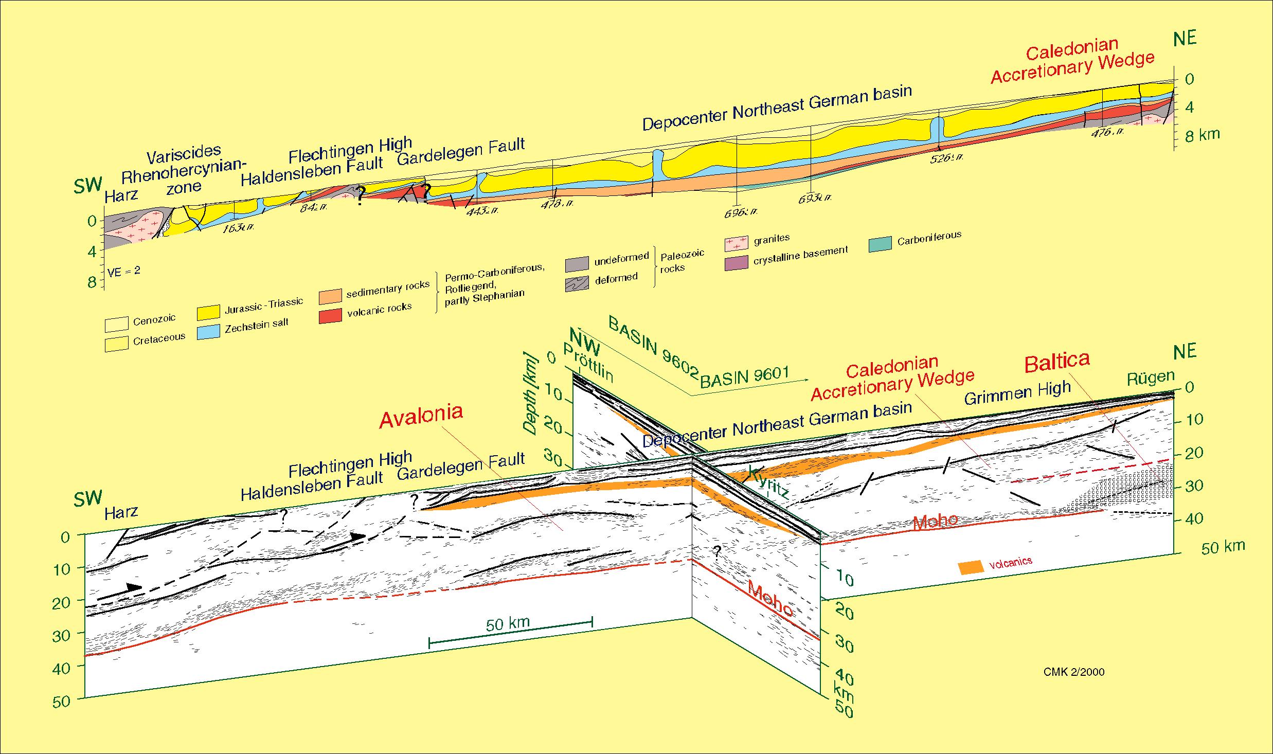
Onshore profiles BASIN 9601 and BASIN 9602:
The combined interpretation of both time-migrated and depth-converted vibroseis and shot sections is summarised with the interpreted seismic linedrawing. For better correlation with geological information, a generalized cross section which runs almost parallel to the main profile BASIN 9601 across the NE German Basin, is shown on top.
The main features are:
- High-resolution imaging of the sedimentary cover: faults, salt structures, and stratigraphic sequences.
- Continuous Zechstein reflection: 1.8 km depth in the N, 4.5 km in the S, cut by the Flechtingen complex and ending at the Harz.
- Mapping of the Moho: 32 km depth in the centre of line 9601, 36 km depth at the basin margins; reflectivity partly weak in the basin centre, asymmetric to the depocentre.
- Intra-crustal reflections: dip towards the centre in the northern half of the basin, dip towards the Harz south of Flechtingen.No precursor rift basin is observed.
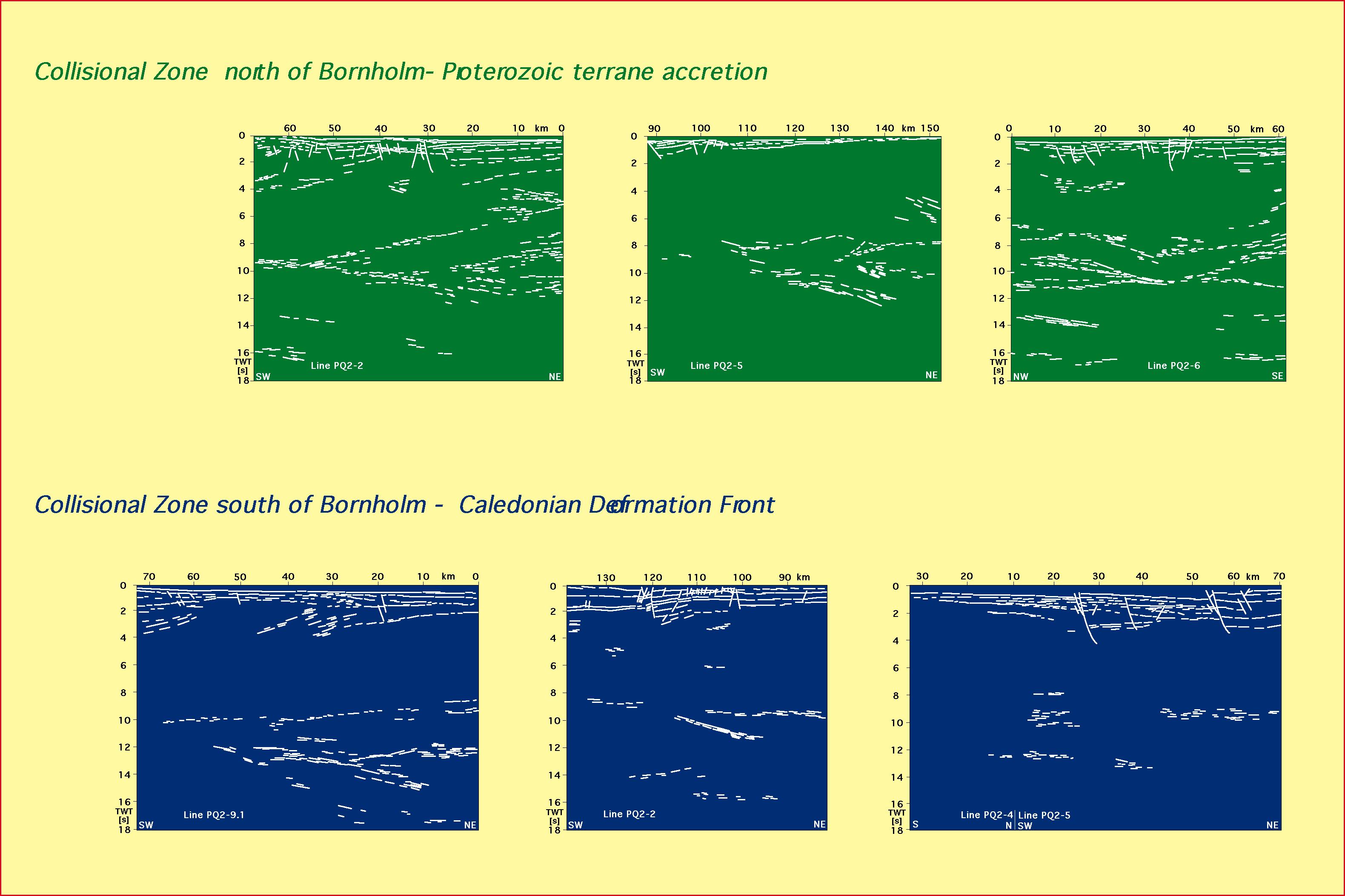
Offshore profiles PQ2-1 - PQ2-10:
The seismic grid with NE-SW and NW-SE trending profiles covers the area between the islands Bornholm and Rügen where the northern rim of the NE German Basin and the Caledonian Deformation Front are located (see location map Baltic Sea). The main results of the lines surrounding Bornholm are summarized first (line drawing offshore), followed by the analysis of combined on- and offshore profiles (line drawing on+offshore).
The main features described by the marine seismic lines are:
- Fault-bounded half-grabens of Triassic age which are almost invariably inverted during the Cretaceous, different in other parts of the basin and the North Sea.
- Inversion structures which may be related to the Tornquist System,
- Highly reflective lower crust,Slightly undulating Moho,Wedge-shaped structures N of Bornholm (parts of older terranes forming the Fennoscandian Shield),
- Caledonian Deformation Front:
- S-dipping structures in upper and middle crust
- => suture zone below NE German mainland,
- N-dipping structures below and further N
- => remnants of Tornquist Ocean subduction ?
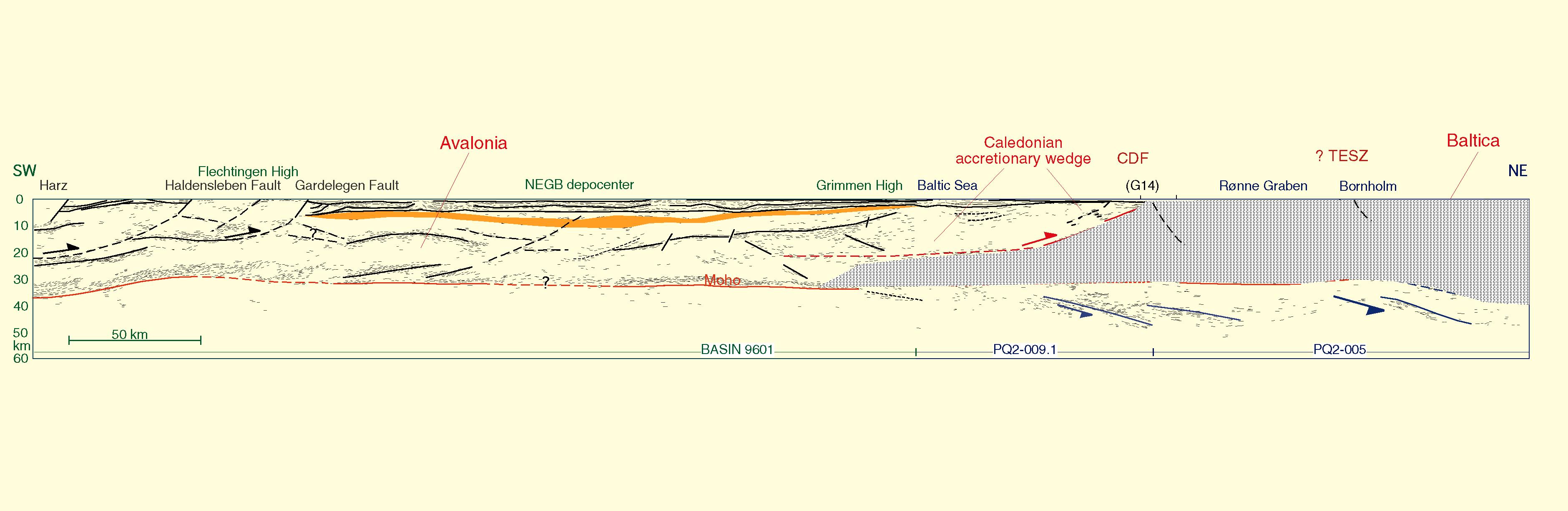
Combined on- and offshore profiles:
The main profiles of the offshore part of BASIN '96 are the NE-SW trending lines PQ2-9.1 and PQ2-5 extending the onshore seismic line 9601 further northwards. Combining these lines, a 500 km long NE-SW trending transect reveals the crustal image of Variscan structures to the south, parts of the Avalonia microplate, and finally the transition to the Baltic Shield.
- SW-dipping reflections suggest that the fossil plate boundary between Avalonia and Baltica extends below the North German mainland.
- There is evidence of lower-crustal thinning and an initial magmatic stage.
- Minor Triassic rifting and Late Cretaceous compressional tectonics indicate an intraplate deformation strongly influenced by older structures.
- Intraplate thinning and contraction are strongly decoupled vertically.
- An almost flat lying Moho may be correlated across the entire onshore seismic profile, with weaker reflectivity in the basin centre, possibly explained by magmatic underplating and/or metamorphic phase changes.
- Thermal destabilization of a stressed, inhomogeneous lithosphere, rather than plate-boundary forces, controlled the evolution of the NE German basin.