

Basin Analysis and Seismic Investigation in North Germany
The intracontinental NE German Basin is of great local and regional scientific and commercial importance. As part of the Southern Permian Basin it is one of a series of related basins which have been extensively explored, not only for their hydrocarbons, but also for other raw materials, groundwater and geothermal energy potential.

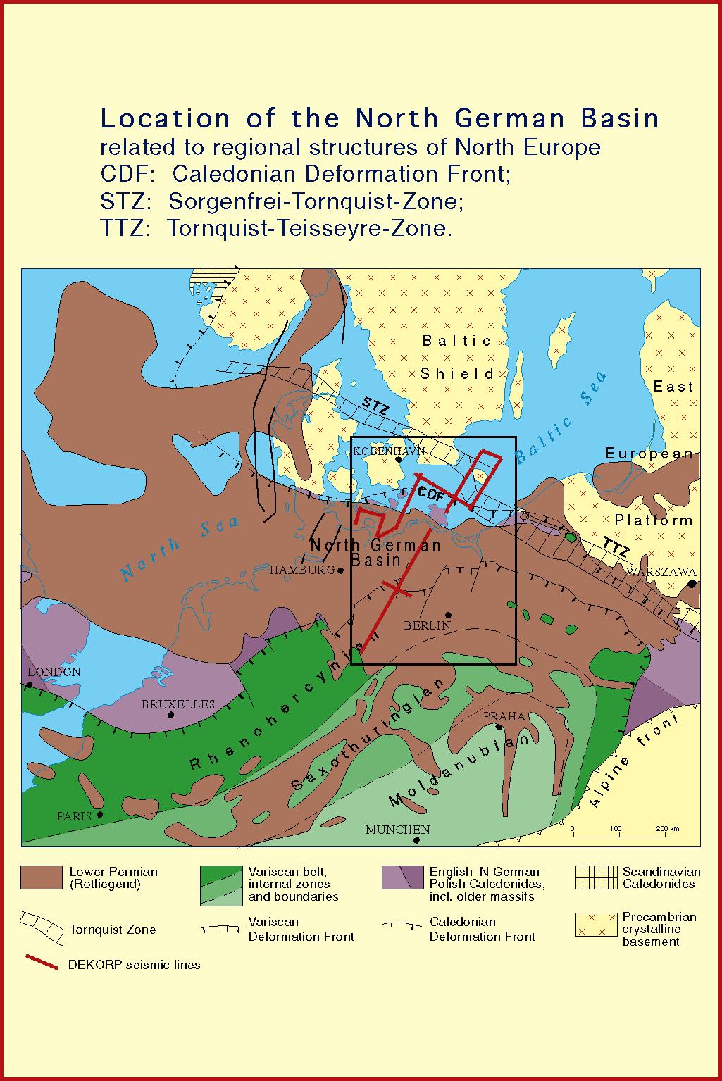
Spanning the region from the Tornquist Zone - an inferred Paleozoic suture - to the Harz Mountains, and from the North Sea to Poland, the NE German Basin shows a complex image with various geophysical anomalies, magmatic intrusions and several changes in tectonic regime and fault systems during the past 300 Ma. The underlying mechanisms controlling basin formation in the region, however, are poorly understood (see tectonic map).
The BASIN '96 seismic data cross the entire NE German Basin and were gathered as a combined offshore-onshore survey (800 km reflection line offshore - 500 km onshore) with the aim
- to consistently image the entire basin and its margins on a lithospheric scale,
- to reveal the basin structure below the base of the Zechstein and into the mantle,
- to image the suture zone between Caledonian and Variscan basement,
- to develop a geodynamic model of the basin formation.
Experiments
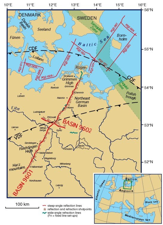
BASIN 9601 and BASIN 9602:
The 330 km long, NE-SW trending onshore seismic transect (profile BASIN 9601) across the NE German Basin and the 75 km long, perpendicular cross-line in the basin centre (profile BASIN 9602) reveal the structure of the basin between the stable Precambrian Baltic Shield to the north and the weaker Mid-European Variscides to the south. Using the same receiver spread, a high-coverage vibroseis and a low-fold explosive seismic technique were used for energy penetration along both profiles.
Additional experiment components were (A) cross-line recordings with 9 layouts on the main profile 9601, and 2 layouts on line 9602 (active and passive vibroseis, recording of all explosive shots); (B) a wide-angle experiment with 4 fixed configurations (Rügen, Gardelegen, Harz, east of line 9602) and constant offset recording in the northern half of the basin (Rügen-Elbe).
long (start) lat (start) long (end) lat (end)
BASIN 9601 10.72239 51.68252 13.29702 54.2276
BASIN 9602 11.55018 53.21026 12.62755 0 52.92041
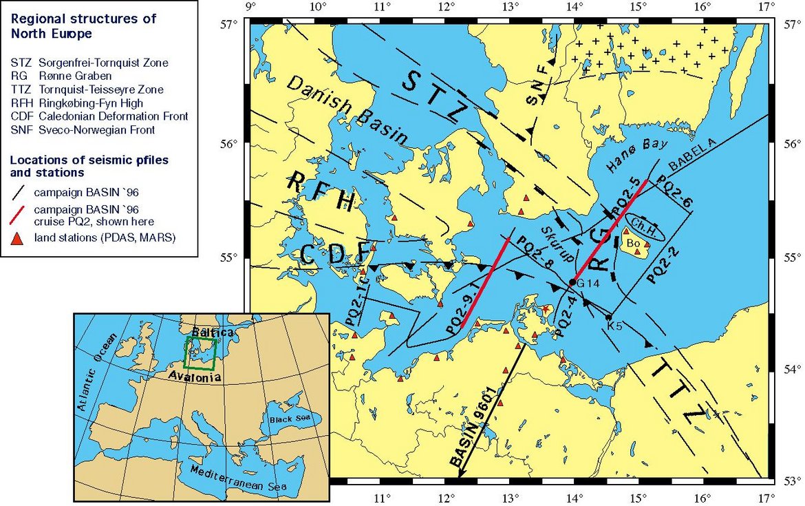
PQ2-002 - PQ2-006, PQ2-008, PQ2-009.1 - PQ2-009.4:
The offshore component was acquired in collaboration with the BGR Hannover during cruise Polar Queen 2. Ten near-vertical incidence reflection seismic lines were shot in the SW Baltic Sea. The signals from the airguns were also recorded by mobile land-stations and broadband seismographs in Sweden, Denmark and Germany, providing important velocity information.
long (start) lat (start) long (end) lat (end)
PQ2-002 14.50306 54.43282 15.81224 55.4118
PQ2-003 13.78264 54.80844 14.61194 54.44079
PQ2-004 13.68379 54.42192 13.99407 54.79248
PQ2-005 13.92652 54.73893 15.29987 55.84952
PQ2-006 15.08574 55.70364 15.80194 55.34904
PQ2-008 12.88209 55.20186 13.9272 54.65921
PQ2-009.1 12.19455 54.30409 13.09032 55.27076
PQ2-009.2 11.41406 54.21583 12.19356 54.30371
PQ2-009.3 11.41396 54.21649 11.55089 54.53526
PQ2-009.4 10.73681 54.6589 11.54975 54.53543
